San Martín de Trevejo
| San Martín de Trevejo municipality | ||
|---|---|---|
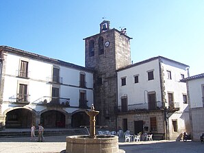
 San Martín de Trevejo - Plaza Mayor
|
||
| coat of arms | Map of Spain | |

|
|
|
| Basic data | ||
| Autonomous Community : |
|
|
| Province : | Cáceres | |
| Comarca : | Sierra de Gata | |
| Coordinates | 40 ° 13 ′ N , 6 ° 48 ′ W | |
| Height : | 795 msnm | |
| Area : | 24.76 km² | |
| Residents : | 778 (Jan. 1, 2019) | |
| Population density : | 31.42 inhabitants / km² | |
| Postal code : | 10892 | |
| Municipality number ( INE ): | 10164 | |
| administration | ||
| Website : | San Martín de Trevejo | |
San Martín de Trevejo ( Fala : Sa Martín de Trebellu ) is a place and a municipality ( municipio ) with 778 inhabitants (as of January 1, 2019) in the north of the province of Cáceres in the autonomous region of Extremadura in western Spain . The old town center is classified as a cultural asset ( Bien de Interés Cultural ) in the Conjunto histórico-artístico category.
location
The place San Martín de Trevejo is located in the Valle de Jálama in the headwaters of the Río del Soto, which is only about 10 km long, a good 120 km (driving distance) northwest of the provincial capital Cáceres at an altitude of about 795 m . In the northeast of the municipality is the third highest mountain in the region, the approx. 1490 m high Jálama . The climate is temperate to warm; Rain (approx. 770 mm / year) falls mainly in the winter half-year.
Population development
| year | 1857 | 1900 | 1950 | 2000 | 2017 |
| Residents | 1,797 | 1,655 | 1,666 | 998 | 805 |
The significant population decline since the 1950s is mainly due to the mechanization of agriculture and the abandonment of small farms and the associated loss of jobs.
economy
The fertile but stony soils in the area provided the basis for the cultivation of wheat and other crops for the inhabitants who, in earlier times, were mainly self-sufficient . Cattle breeding was also practiced to a large extent. Traders, craftsmen and service providers of all kinds gradually settled in the town itself. Today summer tourism plays a major economic role.
history
Bronze , Iron Age , Roman , Visigoth and even Moorish finds were not made. The region was occupied by the Castilian - Leonese troops of Alfonso IX around the year 1200 . (ruled 1188–1230) "recaptured" ( reconquista ) and successively repopulated by Christians from the north and by refugees from Al-Andalus ( repoblación ) . A commandery of the Order of St. John was created . In the High Middle Ages, the place was able to break away from the neighboring village of Santibáñez el Alto against payment of a sum of money .
Attractions
- The main attractions of the place are the Plaza Mayor and the alleys with their quarry stone and / or half-timbered buildings .
- The Casa del Comendador was built in the 16th century from more or less precisely hewn stones; it was the seat of the Johanniter Commandery.
- The church of San Martín de Tours was built in the first half of the 17th century on the site of an older building and was completed in 1653/54. The bell tower (campanario) on the Plaza Mayor comes from the previous church , on which a stone coat of arms of Charles V can still be seen. The three-aisled church with a wooden ceiling houses three imposing late Baroque carved altars in the style of Churriguerism from the 18th century.
- Surroundings
- The summit of Pico Jálama can be climbed as part of a 20-kilometer hike there and back .
Web links
- San Martín de Trevejo, tourism site - photos + information (Spanish)
- San Martín de Trevejo, various - photos + information (Spanish)
Individual evidence
- ↑ Cifras oficiales de población resultantes de la revisión del Padrón municipal a 1 de enero . Population statistics from the Instituto Nacional de Estadística (population update).
- ↑ San Martín de Trevejo - climate tables
- ↑ San Martín de Trevejo - Population Development
- ↑ San Martín de Trevejo - History
- ↑ San Martín de Trevejo - traditional architecture


