
Sandimen
|
Sandimen 三 地 門 鄉 |
|||
.svg) Location of Sandimen District in Pingtung County |
|||
| State : |
|
||
| County : | Pinging | ||
| Coordinates : | 22 ° 49 ′ N , 120 ° 40 ′ E | ||
| Area : | 196.3965 km² | ||
| Residents : | 7,661 (Feb 2018) | ||
| Population density : | 39 inhabitants per km² | ||
| Time zone : | UTC + 8 (Chungyuan time) | ||
| Telephone code : | (+886) (0) 8 | ||
| Postal code : | 901 | ||
| ISO 3166-2 : | TW-PIF | ||
| Community type : | Rural community ( 鄉 , Xiāng ) | ||
| Structure : | 10 villages ( 村 , Cūn ) | ||
| Website : | |||
|
|||

Sandimen ( Chinese 三 地 門 鄉 , Pinyin Sāndìmén Xiāng ) is a rural community in Pingtung County in the Republic of China, Taiwan .
Location and geography
Sandimen is located in the north of Pingtung County in the Central Taiwan Mountains . The neighboring communities are (clockwise): Wutai in the east, Majia in the south, Neipu and Yanpu in the southwest, and Gaoshu in the west (all in Pingtung County), and Liugui and Maolin in the north (both districts of Kaohsiung ). The topography is characterized by relatively inaccessible, wooded mountains. Provincial road 24, which is the main artery of traffic, crosses the municipality to the south.
population
The majority of the population belongs to the Taiwanese indigenous ethnic group, the Paiwan . A minority belongs to the Rukai ethnic group . The population density of around 40 people per km² is extremely low by Taiwanese standards.
history
The origin of the name Sandimen is controversial. According to a semi-official reading, the name is said to be derived from 'Stimor' , which means something like 'shanzhumao' , i.e. 'boar bristle' . According to another view, the name developed directly from the meaning of the three Chinese characters 三 地 門, "three-region gate", insofar as Sandimen was the junction of the three regions of Sandimen, Wutai and Majia.
economy
The dominant branch of the economy is agriculture (mainly subsistence farming ). The most important in terms of quantity are sweet potatoes , taro , corn , pineapple , mangoes , millet and tea. Coffee is grown for the wider Taiwanese market . Since 2011 there have been trials with quinoa .
| Outline Sandimens |
|
Talamakau
青葉 村 Cavak
青山 村 Paridrayan
大 社 村 Tukuvule
德文 村 Tjavatjavang
達 來 村 Djineljepan
安 坡村 Valjulu
馬兒 村 Sagaran
口 社 村 Tjailjaking
賽 嘉 村 Sandi
三 地 村 ← to Paridrayan
|

Administrative division
Sandimen is divided into the following 10 villages (names in Bunun language, Chinese script and transcription):
- Sandi (三 地 村), or Timur (地 磨 兒)
- Djineljepan / Anbaka (安 坡村, Anpo)
- Cavak , (沙漠), (青山 村, Qingshan)
- Valjulu (馬兒 村, Mani)
- Tjavatjavang (達 來 村, Dalai)
- Sagaran (口 社 村, Koushe)
- Talamakau / Aoba (青葉 村, Qingye)
- Tukuvule (德文 村, Dewen)
- Tjailjaking (賽 嘉 村, Saijia)
- Paridrayan / Toa (大 社 村, Taishe)
The administrative seat of the municipality is Sandi. The municipality also has an exclave Rinari (禮 納 里) in the neighboring municipality of Majia. Most of the villagers of Paridrayan (Taishe) settled in the exclave after various natural disasters, in particular Typhoon Morakot (2009), and only a few villagers still live in the original village of Paridrayan.
Attractions
The Dajin waterfall ( ), Zhongshan Park ( ), Dimoer Park ( ), various hiking trails and natural attractions, as well as the culture of the indigenous peoples, especially the Paiwan, are worth seeing .
![]()
![]()
![]()
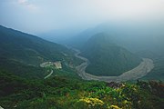
River bed of the northern Ailiao River
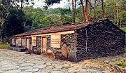
Typical Paiwan house in Sandimen
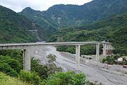
Guchuan Bridge on the border with the neighboring district of Wutai over the Ailiao river valley


Web links
- Sandimen Township ( Maolin National Scenic Area )
Individual evidence
- ↑ Michael Rudolph: Taiwan's Multi-Ethnic Society and the Indigenous Movement: Assimilation or Cultural Revitalization? LIT Verlag, Münster 2003, ISBN 3-8258-6828-1 , p. 356 (Dissertation University of Heidelberg 2001 under the title "Assimilation and Cultural Revitalization - Origins and Implications of the Identity Movement of the Taiwanese Natives (Yuanzhumin) 1983-1996").
- ↑ 四 、 農 林 漁 牧 表 4-1 耕 地 面 積 ("IV. Agriculture, forestry, fisheries and animal husbandry, Table 4-1 tillage area"). (pdf) Pingtung district administration, accessed on April 21, 2018 (Chinese, pages 154ff).
- ^ Agriculture. Pingtung County Government, accessed April 2, 2018 .
- ^ Daily Quinoa - Healthy Returns to Taiwan after Success Abroad. (pdf) Retrieved April 21, 2018 (English).
- ↑ 三 地 門 鄉 地圖 ("Map of the municipality of Sandimen"). Retrieved April 19, 2018 (Chinese).
- ↑ Vibrant Aboriginal Culture of Rinari Tribal Village. www.uptogo.com.tw, accessed April 21, 2018 (English).
- ↑ Dajin Waterfall. Maolin National Scenic Area, accessed April 19, 2018 .
- ↑ Zhongshan Park. Maolin National Scenic Area, accessed April 19, 2018 .
- ↑ Dimoer Park. Maolin National Scenic Area, accessed April 19, 2018 .