Xinpi (Pingtung)
|
Xinpi 新埤 鄉 |
||
 Location of Xinpi in Pingtung County |
||
| State : |
|
|
| County : | Pinging | |
| Coordinates : | 22 ° 29 ' N , 120 ° 35' E | |
| Area : | 59.0102 km² | |
| Residents : | 9,791 (June 2019) | |
| Population density : | 166 inhabitants per km² | |
| Time zone : | UTC + 8 (Chungyuan time) | |
| Telephone code : | (+886) (0) 8 | |
| Postal code : | 925 | |
| ISO 3166-2 : | TW-PIF | |
| Community type : | Rural community ( 鄉 , Xiāng ) | |
| Structure : | 6 villages ( 村 , Cūn ) | |
| Website : | ||
|
|
||
Xinpi ( Chinese 新埤鄉 , Pinyin Xīnpí Xiang , W.-G. Hsin 1 -p'i 2 Hsiang 1 , PEH OE jī Sinpí Siang ) is a rural municipality in Pingtung County on Taiwan ( Republic of China ).
location
Xinpi is located inland a few kilometers north of the small port of Fangliao in the southeast corner of the Pingtung Plain . To the east, the foothills of the central mountains form the natural boundary. The district has a quadrangular shape, the edge lengths are of different lengths (about 5.3 × 7.7 × 9.2 × 11.0 km). The terrain is flat to hilly and gradually rises to the east. The small river Linbian ( 林 邊 溪 , Línbiān Xī ) flows through Xinpi from northeast to southwest . The neighboring communities are Laiyi in the east, Fangliao and Jiadong in the south, Linbian and Nanzhou in the west, and Chaozhou and Wanluan in the north.
history
The first Hakka settlers came to the area as early as 1690. At that time the area was still densely forested and affected by regular flooding. The settlers also fed on fishing until the river gradually silted up and was no longer navigable. There are various theories about the origin of the place name Xinpi . It is said to be derived from the irrigation systems previously used in agriculture. During the time of the Japanese rule (1895-1945) the 'Village Xinpi' ( 新埤 庄 , Xīnpí Zhuāng ) was set up as an administrative unit . After Taiwan was taken over by the Republic of China, the 'rural community Xinpi' ( 新埤 鄉 , Xīnpí Xiāng ) was created, initially in Kaohsiung County and from 1950 in the newly established Pingtung County .
population
The Hakka population is roughly half. According to official statistics, 152 people (around 1.5%) belonged to the indigenous peoples at the end of 2017.
| Outline of Xinpi |

|
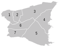
Administrative division
Xinpi is divided into 6 villages ( 村 , Cūn ):
1 Xinpi ( 打鐵 村 )
2 Nanfeng ( 南豐 村 )
3 Wanlong ( 萬隆 村 )
4 Xiangtan ( 餉 潭村 )
5 Jihu ( 箕 湖村 )
6 Jiangong ( 建功 村 )
7 Xinbi ( 新埤 村 )
traffic
Provincial road 1 runs along the western edge of Xinpi in a north-south direction (further west parallel to it, national road 3 ). Otherwise, Xinpi is crossed by several county roads - 185, 187 乙 (187b), 189.
Agriculture and fishing
Products of the local agriculture are papaya , dragon fruit , banana , mango , Java apple , pineapple , watermelon . In addition, orchids are grown in horticulture.
Tourism, sightseeing
Xinpi doesn't have too many special features. The old village gate of Jiangong, which was built around 1820 and rebuilt in 1882, is a worth seeing example of rural Hakka architecture. In the village of Wanlong there is the Yuhuan Church ( 玉環 善牧 天主堂 , Yùhuán Shànmù Tiānzhǔtáng , ), a small stone church that was built in 1965 by German Dominicans for refugees from mainland China. After sugar cane cultivation in the area came to a standstill, the population declined and the church was abandoned. After being in disrepair for 30 years, it was renovated and reopened to the public in April 2017.
![]()
Web links
Individual evidence
- ↑ Park Introduxtion> Coverage. thcdc.hakka.gov.tw, accessed August 3, 2019 .
- ↑ 新埤 鄉 簡介 ("Introduction to the Xinpi Rural Community"). Xinpi website, accessed August 3, 2019 (Chinese (traditional)).
- ↑ 楊文 山 (Yang Wenshan): 全國 客家 人口 基礎 資料 調查 研究 ("Basic data survey on the national Hakka population") . 2004, ISBN 957-01-9320-4 , Appendix: 鄉鎮 市區 臺灣 客家 人口 數 及 比例 (“Number and Proportion of the Taiwanese Hakka Population in Towns and Cities”) - (Chinese (traditional), online ).
- ↑ 原住民 戶數 及 人數 Households and Persons of Indigenous People. (xls) Taiwan Ministry of the Interior, accessed August 4, 2018 (Chinese, English).
- ↑ 新埤 鄉 農產品 ("Agricultural Products of Xinyi"). Xinpi website, accessed August 3, 2019 (Chinese (traditional)).
- ↑ 建功 庄東 柵門 ("East Gate of Jiangong Village"). nchdb.boch.gov.tw (Heritage Database), accessed August 3, 2019 (Chinese (Traditional)).
- ↑ Kelly Her: Hidden Gem. Taiwan Today, March 1, 2018, accessed August 3, 2019 .
- ↑ 打卡 亮點! 荒廢 30 年 屏東 玉環 天主堂 絕美 復活 ("A highlight !: After 30 years of decline, the Yuhuan Catholic Church in Pingtung has reopened"). Liberty Times, April 13, 2017, accessed August 3, 2019 (Traditional Chinese).


