
Yanpu
|
Yanpu 鹽 埔 鄉 |
|||
.svg) Location Yanpus in Pingtung County |
|||
| State : |
|
||
| County : | Pinging | ||
| Coordinates : | 22 ° 45 ' N , 120 ° 34' E | ||
| Height : | 5 - 63 m | ||
| Area : | 64.3493 km² | ||
| Residents : | 25,402 (Aug 2019) | ||
| Population density : | 395 inhabitants per km² | ||
| Time zone : | UTC + 8 (Chungyuan time) | ||
| Telephone code : | (+886) (0) 8 | ||
| Postal code : | 907 | ||
| ISO 3166-2 : | TW-PIF | ||
| Community type : | Rural community ( 鄉 , Xiāng ) | ||
| Structure : | 12 villages ( 村 , Cūn ) | ||
| Website : | |||
|
|||

Yanpu ( Chinese 鹽 埔 鄉 , Pinyin Yánpǔ Xiāng , Pe̍h-ōe-jī Iâm-po͘-hiong ) is a rural community in Pingtung County in the Republic of China, Taiwan .
description
Yanpu is located in the northern section of the Pingtung Plain. The terrain is flat, the height above sea level varies between 5 and 63 meters and generally increases towards the east. The natural border to the north and northeast is essentially formed by the Ailiao River ( 隘寮溪 ), a tributary of the Gaoping . The neighboring communities are Gaoshu in the north and northeast, Ligang in the northwest, Jiuru in the west, Changzi in the south and in very small sections Neipu and Sandimen in the southeast.
history
The first residents of Yanpu were Austronesian ethnic groups ( Pingpu ). During the reign of Kangxi , the immigration of Han Chinese settlers from the Chinese coastal province of Fujian began . According to tradition, the settlers bought the land from the autochthonous population in exchange for 10 carts of salt. The place name Yanpu was derived from the Pingpu name Caopu ( 草埔 ) . At the time of the Japanese rule (1895-1945), agriculture and in particular tobacco growing were strongly promoted, and a Japanese model settlement was founded by colonists from Kyushu in the village of Shirong . After Taiwan became part of the Republic of China in 1946, Yanpu was organized as a 'rural community' ( 鄉 , Xiāng ), first in Kaohsiung County and from 1951 in the newly established Pingtung County.
population
The population consists largely of Hoklo and a minority of Hakka (less than 10%). Members of indigenous peoples are only a small minority (less than 1%).
| Outline of Yanpu |

|
administration
Yanpu is divided into 12 villages ( 村 , Cūn ):
1 Yanzhong ( 鹽 中 村 )
2 Yannan ( 鹽 南村 )
3 Zhenxing ( 振興 村 )
4 Jiu'ai ( 久 愛 村 )
5 Gaolang ( 高 朗 村 )
6 Xinwei ( 新 圍村 )
7 Xiner ( 新 二 村 )
8 Luoyang ( 洛陽 村 )
9 Pengcuo ( 彭 厝村 )
10 Yonglong ( 永隆 村 )
11 Shirong ( 仕 絨 村 )
12 Yanbei ( 鹽 北 村 )
traffic
In the far west Yanpu is traversed in a short section of less than 1 kilometer from Highway 3 , which otherwise passes Yanpu to the south. Other major roads are Provincial Road 27, which runs through Yanpu in a straight line from northeast to southwest, and Provincial Road 24, which briefly touches Yanpu in the extreme south-east.
Agriculture
Yanpu is used intensively for agriculture and the state-controlled agriculture is systematically expanded. The main crops are Chinese jujubes , Java apples and mangoes . Aquaculture plays an important role with the breeding of freshwater shrimp ( Macrobrachium rosenbergii ) (especially in the village of Shirong). Butterfly lilies ( Hedychium coronarium ), which are used as a spice, are cultivated as a specialty .
Educational institutions
Yanpu is home to the small private Tajen University ( 大仁 科技 大學 , Dàrén kējì dàxué ), which emerged from a pharmaceutical university founded in 1966.
particularities
There are two more notable temples in Yanpu, Chaofeng Temple ( 朝鳳 宮 , Cháo fèng gōng ), a Mazu Temple in Yanbei Village, and Daitianfu Temple ( 代天府 , Dài tiānfǔ , ) in Gaolang Village. The old house of the Ye family ( 葉 家 古厝 , Yè jiā gǔ cuò ), which was built at the beginning of the 20th century, is worth seeing . The cycle path network is being expanded for tourism.
![]()
![]()
![]()
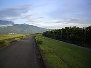
View of the foothills of the central mountains

Daren Geshu - an old cedar tree in Xinwei Village

Defile in Yanpu


Web links
Individual evidence
- ↑ 本鄉 簡介: 地理位置 ("Community introduction: Geographical location"). Yanpu website, accessed December 21, 2019 (Traditional Chinese).
- ↑ 本鄉 簡介: 尋根 溯源 ("Congregation Introduction: Origins"). Yanpu's website, accessed December 18, 2019 (Traditional Chinese).
- ↑ a b 本鄉 簡介: 鹽 埔 檔案 ("Community introduction: data"). Yanpu website, accessed December 21, 2019 (Traditional Chinese).
- ↑ 楊文 山 (Yang Wenshan): 全國 客家 人口 基礎 資料 調查 研究 ("Basic data survey on the national Hakka population") . 2004, ISBN 957-01-9320-4 , Appendix: 鄉鎮 市區 臺灣 客家 人口 數 及 比例 (“Number and Proportion of the Taiwanese Hakka Population in Towns and Cities”) - (Chinese (traditional), online ).
- ↑ 原住民 戶數 及 人數 Households and Persons of Indigenous People. (xls) Ministry of Interior of Taiwan, accessed November 30, 2019 (Chinese, English).
- ↑ 村里 總覽: 村里 總覽. Yanpu website, accessed December 21, 2019 (Traditional Chinese).
- ↑ 行政 區域 圖 ("administrative area map"). Yanpu website, accessed December 21, 2019 (Traditional Chinese).
- ↑ 本鄉 簡介: 交通 環境 ("Community introduction: traffic environment"). Yanpu's website, accessed December 22, 2019 (Traditional Chinese).
- ↑ 本鄉 簡介: 農 特 產品 ("Community introduction: agricultural products"). Yanpu's website, accessed December 22, 2019 (Traditional Chinese).
- ↑ Homepage. Tajen University, accessed December 22, 2019 (Chinese, English).
- ↑ 本鄉 簡介: 旅遊 資訊. Yanpu's website, accessed December 22, 2019 (Traditional Chinese).
- ↑ 鹽 埔 鄉 戀歌 「大 仁哥 樹」 深情 守候. Liberty Times, February 4, 2015, accessed December 22, 2019 (Traditional Chinese).