Santa Bárbara de Carhuacayán district
| Santa Bárbara de Carhuacayán district | |
|---|---|
 The district of Santa Bárbara de Carhuacayán is located in the northwest of the province of Yauli (marked in red) |
|
| Basic data | |
| Country | Peru |
| region | Junín |
| province | Yauli |
| Seat | Santa Bárbara de Carhuacayán |
| surface | 646.3 km² |
| Residents | 1104 (2017) |
| density | 1.7 inhabitants per km² |
| founding | April 7, 1954 |
| ISO 3166-2 | PE-JUN |
| Website | munisantabarbaradecarhuacayan.gob.pe (Spanish) |
| politics | |
| Alcalde District | Juan Carlos Llacza Alcantara (2019-2022) |
| Political party | Movimiento Político Regional Perú Libre |
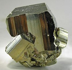
| Pyrite from the Carhuacayan mine | |
Coordinates: 11 ° 12 ′ S , 76 ° 17 ′ W
The Santa Bárbara de Carhuacayán district is located in the Yauli province of the Junín region in central Peru . The district was founded on April 7, 1954. It has an area of 646.29 km². At the 2017 census, there were 1,104 residents in the district. In 1993 the population was 1301, in 2007 it was 1935. The district administration is located in the 4137 m high village of Santa Bárbara de Carhuacayán with 623 inhabitants (as of 2017).
Geographical location
The Santa Bárbara de Carhuacayán district is located in the northwest of the Yauli province in the Andean highlands , about 125 km northeast of the state capital Lima . The district is drained via the Río Mantaro , which flows south along the eastern district boundary. The western border of the district forms the continental watershed , which runs along the Peruvian Western Cordillera . There are several lakes in the district, including Lake Huascacocha in the northwest. In the Santa Bárbara de Carhuacayán district there are several mines that mine ore, including the Alpamarca mine in the southwest, operated by the Volcan Compañía Minera .
The district of Santa Bárbara de Carhuacayán is bordered to the west by the districts of Atavillos Alto and Santa Leonor (both in the province of Huaura ), to the north by the district of Huayllay ( province of Pasco ), to the east by the districts of Ondores and Junín (both in the province of Junín ) and in the south to the Marcapomacocha district .
Individual evidence
- ^ A b Peru: Junín - Provinces & Districts . www.citypopulation.de. Retrieved February 25, 2020.
