Schwand near Nuremberg
|
Schwand near Nuremberg
Schwanstetten market
Coordinates: 49 ° 18 ′ 12 ″ N , 11 ° 7 ′ 21 ″ E
|
|
|---|---|
| Height : | 338-370 m above sea level NHN |
| Residents : | 3210 |
| Postal code : | 90596 |
| Area code : | 09170 |
|
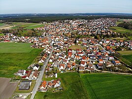
Aerial photo of Schwand (2020)
|
|
Waned in Nuremberg (officially disappeared b.Nürnberg ) is a part of the market Schwanstetten in the Middle Franconian district of Roth .
location
Schwand is located south of the Leerstetten district and about 18 kilometers south of Nuremberg and is largely surrounded by forest areas. The Hembach flows through the town in the south and flows into the Rednitz in the neighboring Rednitzhembach . There is an industrial park in the east .
Neighboring cities and communities are Schwabach , Roth , Rednitzhembach , Allersberg and Wendelstein .
history
The time when the clearing settlement was established is unknown. Schwand was first mentioned in 1186, when the church at that time was consecrated by Bishop Otto von Eichstätt .
Until the district reform , which came into force on July 1, 1972, the Schwand market belonged to the disbanded district of Schwabach . On May 1, 1978, Schwand and the neighboring municipality of Leerstetten merged to form the new municipality of Schwanstetten, which Schwand gave the title market .
Population development
- 1910: 679 inhabitants
- 1925: 651 inhabitants
- 1933: 661 inhabitants
- 1939: 691 inhabitants
- 1961: 1009 inhabitants
- 1970: 1339 inhabitants
- 1987: 2676 inhabitants
- 2013: 3210 inhabitants
societies
In addition to many other clubs, there is a sports club, 1. FC Schwand.
traffic
The district road RH 1 leads to Rednitzhembach to federal road 2 and to state road 2409 or to Leerstetten in the direction of Nuremberg . The district road RH 35 runs after Harrlach towards Allersberg . Communal roads lead to Furth and Harm .
literature
- Johann Kaspar Bundschuh : Schwand near Nuremberg . In: Geographical Statistical-Topographical Lexicon of Franconia . tape 5 : S-U . Verlag der Stettinische Buchhandlung, Ulm 1802, DNB 790364328 , OCLC 833753112 , Sp. 231 ( digitized version ).
- Friedrich Eigler : Schwabach (= Historical Atlas of Bavaria, part of Franconia . I, 28). Michael Laßleben, Kallmünz 1990, ISBN 3-7696-9941-6 , p. 422 f., 485 .
- Karl Gröber, Felix Mader : City and district of Schwabach (= The art monuments of Bavaria . Middle Franconia 7). R. Oldenburg, Munich 1939, DNB 366496239 , p. 298-299 .
- Gottfried Stieber: Schwandt . In: Historical and topographical news from the Principality of Brandenburg-Onolzbach . Johann Jacob Enderes, Schwabach 1761, p. 741-742 ( digitized version ).
- Pleikard Joseph Stumpf : Schwand near Nuremberg . In: Bavaria: a geographical-statistical-historical handbook of the kingdom; for the Bavarian people . Second part. Munich 1853, p. 762 ( digitized version ).
- Willi Ulsamer (Ed.): 100 Years of the Schwabach District (1862–1962). A home book . Schwabach 1964, DNB 984880232 , p. 545-559 .
Web links
- Schwand near Nuremberg in the location database of the Bayerische Landesbibliothek Online . Bayerische Staatsbibliothek, accessed on September 23, 2019.
- Schwand near Nuremberg in the Topographia Franconiae of the University of Würzburg , accessed on September 23, 2019.
- Schwand near Nuremberg in the historical directory of the Association for Computer Genealogy , accessed on September 23, 2019
Individual evidence
- ↑ Schwand near Nuremberg in the Bavaria Atlas
- ↑ http://www.schwanstetten.de/index.php?id=26 History of Schwand
- ↑ a b c Federal Statistical Office (ed.): Historical municipality directory for the Federal Republic of Germany. Name, border and key number changes in municipalities, counties and administrative districts from May 27, 1970 to December 31, 1982 . W. Kohlhammer, Stuttgart / Mainz 1983, ISBN 3-17-003263-1 , p. 733 .
- ↑ http://www.ulischubert.de/geografie/gem1900/gem1900.htm?mittelfranken/schwabach.htm
- ^ Michael Rademacher: German administrative history from the unification of the empire in 1871 to the reunification in 1990. City and district of Schwabach. (Online material for the dissertation, Osnabrück 2006).
- ↑ http://gov.genealogy.net/ShowObjectSimple.do?id=SCHERGJN59NH
- ↑ Archived copy ( memento of the original from September 24, 2015 in the Internet Archive ) Info: The archive link was inserted automatically and has not yet been checked. Please check the original and archive link according to the instructions and then remove this notice.

