Sołtmany (Kruklanki)
| Sołtmany | ||
|---|---|---|

|
|
|
| Basic data | ||
| State : | Poland | |
| Voivodeship : | Warmia-Masuria | |
| Powiat : | Giżycko | |
| Gmina : | Kruklanki | |
| Geographic location : | 54 ° 2 ' N , 22 ° 1' E | |
| Residents : | ||
| Postal code : | 11-612 | |
| Telephone code : | (+48) 87 | |
| License plate : | NGI | |
| Economy and Transport | ||
| Street : | Kruklanki - Żywki Małe - Żywki ↔ Mazuchówka | |
| Gawliki Wielkie → Sołtmany | ||
| Rail route : | no rail connection | |
| Next international airport : | Danzig | |
Sołtmany [ sɔu̯tˈmanɨ ] ( German Soltmahnen ) is a village in the Polish Warmian-Masurian Voivodeship and belongs to the rural community of Kruklanki (Kruglanken) in the Giżycki powiat ( Lötzen district ).
Geographical location
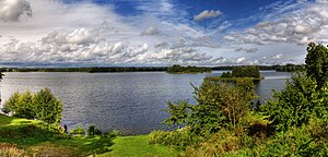
Sołtmany is located on the southern shore of Lake Soltmahn ( Jezioro Sołtmany in Polish ) in the north-east of the Warmian-Masurian Voivodeship. The former district town of Angerburg (Polish: Węgorzewo) is 27 kilometers to the northwest. The current district metropolis Giżycko (Lötzen) is 16 kilometers to the west.
history
The village called Solthma before 1785 was founded in 1546. After 1885 it "moved" from the Siewken district ( Polish Żywki ) to the newly established neighboring district, for which it was named. It existed until 1945 and was part of the district Angerburg in Administrative district Gumbinnen the Prussian province of East Prussia .
In 1910 there were 522 inhabitants registered in Soltmahnen. Their number rose to 582 by 1925, was 572 in 1933 and was still 517 in 1939.
As a result of the war, Soltmahnen came to Poland in 1945 with all of southern East Prussia and since then has had the Polish name form “Sołtmany”. The village is now the seat of a Schulzenamt (Polish sołectwo) and a village in the rural community Kruklanki (Kruglanken) in the powiat Giżycki ( Lötzen district ), before 1998 the Suwałki Voivodeship and since then the Warmian-Masurian Voivodeship.
Soltmahnen District (until 1945)
The Soltmahnen district, which existed until 1945, only ever had two villages:
| German name | Polish name |
|---|---|
| New Freudenthal | Boćwinka |
| Soltmahnen | Sołtmany |
church
Before 1945, Soltmahnen was parish in the Evangelical Church of Kruglanken in the church province of East Prussia of the Church of the Old Prussian Union and in the Catholic parish church of St. Bruno Lötzen (in Polish: Giżycko) in the Diocese of Warmia .
Today Sołtmany has a private church of the Catholic parish in Wydminy (Widminnen) in the Diocese of Elk (Lyck) of the Roman Catholic Church in Poland and the Protestant church Wydminy , a filial community of the parish in Giżycko in the diocese Mazury the Evangelical Augsburg Church in Poland .
Meteorite "Sołtmany"
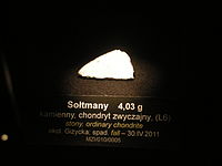
On the morning of April 30, 2011 at 6:03 a.m., a stone meteorite of the chondrite type from group L6, which now bears the name of the village, struck Sołtmany .
traffic
Sołtmany is located on a side road that connects Kruklanki (Kruglanken) via Żywki Małe (Louisenhof) and Żywki (Siewken) with Mazuchówka (Masuchowken , 1936 to 1945 Rodental) . A side street from Gawliki Wielkie (Groß Gablick) from the east ends in the town. There is no rail link.
Individual evidence
- ↑ Polish Postal Code Directory 2013, p. 1174
- ↑ Dietrich Lange, Geographical Location Register East Prussia (2005). Soltmahnen
- ^ Rolf Jehke, Siewken district
- ↑ a b Rolf Jehke, Soltmahnen District
- ^ Uli Schubert, community directory, district of Angerburg
- ↑ Michael Rademacher: German administrative history from the unification of the empire in 1871 to the reunification in 1990. The district of Angerburg (Polish Wegorzewo). (Online material for the dissertation, Osnabrück 2006).
- ↑ Walther Hubatsch : History of the Protestant Church in East Prussia. Volume 3: Documents. Göttingen 1968, p. 476
- ^ Entry at the Meteoritical Society


