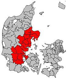
Urban region of East Jutland
The urban region of East Jutland (Danish Byregion Østjylland , Den østjyske Byregion or, jokingly, Den østjyske millionby , i.e. the metropolis of East Jutland) is a Danish regiopole region in Jutland that has been developed since 2008 . The region connects the growth centers of Aarhus and the city triangle Trekantområdet with Vejle , Kolding and Fredericia .
In 2012, around 1.24 million people lived in the seventeen affiliated municipalities. That is more than a fifth of the total Danish population. The urban region of East Jutland covers almost a quarter of Denmark with an area of 10,004 km² (43,094 km² without the Faroe Islands and without Greenland ). Therefore, the population density of the region (125 inh / km²) is lower than the Danish average.
List of municipalities
| Communities | Residents (as of 2020) |
surface |
Population density (E / km²) |
Headquarters of the administration |
|---|---|---|---|---|
| Aarhus Commune | 349,983 | 468.87 km² | 641 | Aarhus |
| Billund Commune | 26,608 | 536.51 km² | 49 | Grindsted |
| Favrskov commune | 48,397 | 539.36 km² | 85 | Hinnerup |
| Fredericia Commune | 51,377 | 134.46 km² | 369 | Fredericia |
| Haderslev Commune | 55,670 | 701.98 km² | 81 | Haderslev |
| Hedensted Commune | 46,722 | 551.47 km² | 83 | Hedensted |
| Horsens Commune | 90,966 | 542 km² | 149 | Horsens |
| Kolding municipality | 93,175 | 605 km² | 146 | Kolding |
| Middelfart municipality | 38,853 | 299.96 km² | 125 | Middelfart |
| Norddjurs municipality | 37,089 | 721.18 km² | 53 | Grenaa |
| Odder commune | 22,844 | 225.13 km² | 96 | Odder |
| Randers Commune | 97,805 | 800.14 km² | 117 | Randers |
| Silkeborg Municipality | 94.026 | 864.89 km² | 102 | Silkeborg |
| Skanderborg Municipality | 62,678 | 436.1 km² | 129 | Skanderborg |
| Syddjurs municipality | 42,962 | 696.34 km² | 59 | Rønde |
| Vejen municipality | 42,742 | 814.36 km² | 52 | Vejen |
| Vejle municipality | 115,748 | 1066.32 km² | 99 | Vejle |
| Urban region of East Jutland | 1,317,645 | 10,004 km² | 122 |
