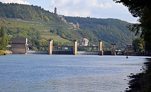
Neckarzimmern barrage
| Neckarzimmern barrage | ||
|---|---|---|
| location | ||
|
|
||
| Coordinates | 49 ° 18 '58 " N , 9 ° 7' 56" E | |
| Country: | Germany | |
| Place: | Neckarzimmern | |
| Waters: | Neckar | |
| Water kilometers : | km 85.90 | |
| Data | ||
| Construction time: | 1935 | |
| lock | ||
| Type: | Chamber lock | |
| Usable length: | 108.3 / 107.8 m | |
| Usable width: | 12 m | |
| Height upstream : | 138.63 m | |
| Average height of fall : |
5.60 m | |
| Others | ||
| Associated power plant: | 3.5 MW run-of-river power plant | |
The Neckarzimmern barrage is located on the Neckar in Baden-Württemberg . It is crossed by a weir that is also used as a cycle path. The Haßmersheim district is located on the southern side of the Neckar .
construction
The barrage consists of three weir fields with five structures. The entire system is spanned over 140 meters by an approximately two-and-a-half meter wide weir walkway built in a trough construction. It is part of the Neckar Valley Cycle Route and is frequented by both cyclists and pedestrians.
Construction work
The jetty, which was in great need of renovation, was completely replaced during the 2013 summer vacation. Instead of an asphalt surface, a grating is now used to prevent the deposition of ice and snow.
location
Seen from the Rhine , the barrage is the ninth facility.
Web links
- Federal waterways and shipping administration, Office for Neckar Development Heidelberg, Neckarzimmern lock
- Federal waterways and shipping administration, Office for Neckar Development Heidelberg, Neckarzimmern weir pier
Individual evidence
- ↑ Neckarzimmern: Weir footbridge has been redone. Rhein-Neckar Zeitung, September 6, 2013, accessed on September 25, 2018 .
| Upstream | Crossing the Neckar | Downstream |
| Neckarsteg Haßmersheim | Weir footbridge |
Road bridge B292 |

