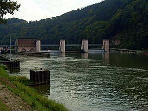
Neckarsteinach barrage
| Neckarsteinach barrage | ||
|---|---|---|
| location | ||
|
|
||
| Coordinates | 49 ° 24 '4 " N , 8 ° 50' 31" E | |
| Country: | Germany | |
| Place: | Neckarsteinach (right side), Neckargemünd (left side) | |
| Waters: | Neckar | |
| Water kilometers : | km 39.30 | |
| Data | ||
| Construction time: | 1931 weir and first chamber, 1957 second chamber |
|
| lock | ||
| Usable length: | 110 m | |
| Usable width: | 12 m | |
| Height upstream : | 116.44 m | |
| Average height of fall : |
4.68 m | |
| Others | ||
| Associated power plant: | 3.6 MW run-of-river power plant | |
The Neckarsteinach barrage is a river barrage of the Neckar and consists of a double lock on the right bank, a three-field weir on the left bank and a power plant in the middle of the entire system. The state border between Hesse and Baden-Wuerttemberg runs across the center of the facility , with both the locks, the power plant and the right half of the weir (viewed in the direction of the Neckar) belonging to Hesse. The left half of the weir, below Dilsberg , belongs to the district of Neckargemünd and thus to Baden-Württemberg.
location
Seen from the Rhine , the weir is the fifth installation. It is the only facility on the Neckar that extends over two federal states.
Web links
Commons : Neckarsteinach barrage - collection of images, videos and audio files
- Federal waterways and shipping administration, Office for Neckar Development Heidelberg, Neckarsteinach lock

