
Subtropical Storm One (1982)
| Subtropical Storm ( SSHWS ) | ||
|---|---|---|
 |
||
| Emergence | June 18, 1982 | |
| resolution | June 20, 1982 | |
|
Peak wind speed |
|
|
| Lowest air pressure | 984 mbar ( hPa ; 29.1 inHg ) | |
| dead | 3 | |
| Property damage | $ 10 million (1982) | |
|
Affected areas |
Cuba , Florida , Georgia , Virginia , North Carolina , South Carolina, and Canadian Maritime Provinces | |
| Season overview: 1982 Atlantic hurricane season |
||
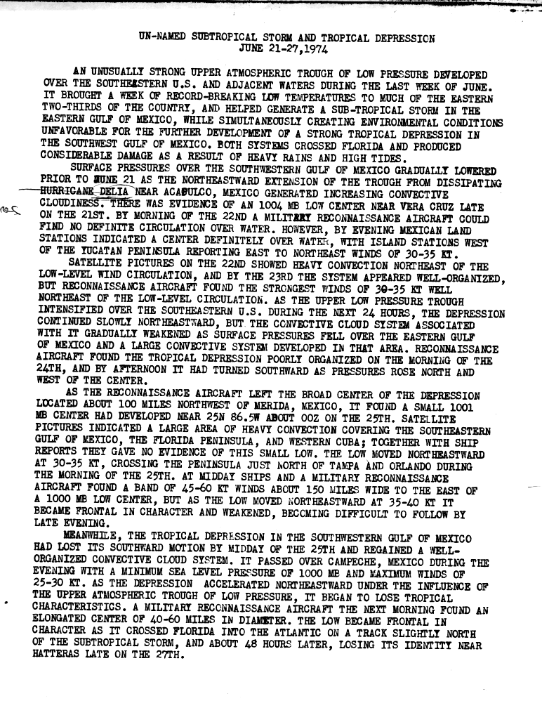
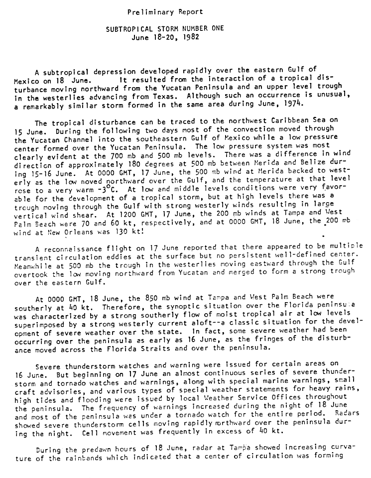
Subtropical Storm One was the only subtropical cyclone in the inactive Atlantic hurricane season of 1982 . The storm originated from two different systems in the Caribbean Sea and the Gulf of Mexico . The two systems merged into a trough as a circulation began to form off the coast of Florida on June 18 . The low pressure system moved over Florida and intensified overland into a storm. This came over the Atlantic Ocean and moved to the northeast. On June 20, the Newfoundland system became extra-tropical. The storm was the only system that hit the east coast of the United States . It caused $ 10 million in property damage (1982) and three people died from the effects of the storm.
Storm course

The subtropical storm originated in an unusual way as a result of the mutual influence of two different systems near the Yucatán peninsula . Such a cyclogenesis is not an isolated case, however; in 1974 an unnamed subtropical storm formed in a very similar way. A reconnaissance flight on June 17 revealed that several emerging circulations existed on the surface, but no well-defined storm center. The first fault can be traced back to the northwestern Caribbean until June 15 . It migrated north, along with a low pressure area that formed over the Yucatán. A trough merged with the depression, creating an even stronger trough over the eastern Gulf of Mexico. The conditions in the Gulf of Mexico were favorable for the development of a tropical system. Some storms occurred over Florida from June 16, as the foothills of the fault moved through the Florida Strait and across the peninsula.
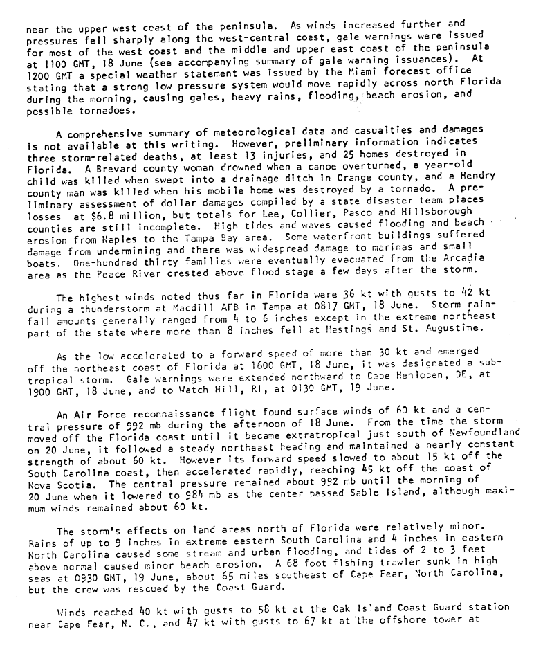
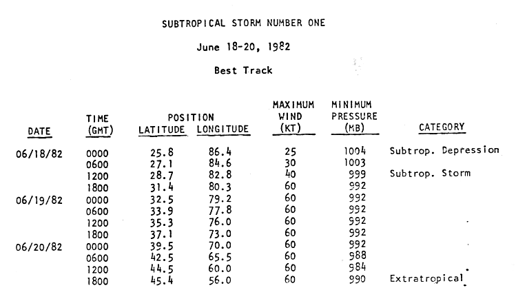
On June 18, circulation began to form in the eastern Gulf and storm warnings were issued. The system landed just north of Spring Hill on the morning of June 18 and was declared Subtropical Storm One during the day. At the time, subtropical storms were not named by the National Hurricane Center , but were given an ordinal number. The subtropical storm came back over water, moved to the northeast and crossed on 19 June, the Outer Banks of North Carolina . Although the minimum central air pressure remained low, the circulation expanded and distorted. The subtropical storm reached its peak on June 18th with wind speeds of 110 km / h, but only reached its lowest air pressure on June 20th with 984 mbar (hPa). On the same day, the subtropical storm near the Canadian maritime provinces was declared an extra-tropical system.
Preparations
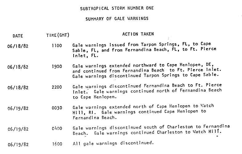
Several storm warnings were issued in connection with the subtropical storm. Severe weather warnings were issued for Florida on June 16, and tornado warnings and sea weather warnings, especially for small craft, were added the next day. Due to the heavy rains, local warnings of flash floods were issued. Storm warnings were issued for the west coast of Florida on June 18 and 19, and were lifted on June 19 at 4:00 p.m. UTC. On the same day, there was a storm warning between Cape Henlopen , Delaware and Watch Hill , Rhode Island.
Because of the subtropical storm, the biennial sailing regatta from Newport , Rhode Island to Bermuda was postponed for two consecutive days because of the forecast storm. This measure prevented a disaster on the high seas .
Effects
In the area of its main band over Cuba, the storm poured 728 mm of rain.

The storm had its greatest impact when it reached Florida on the morning of June 18, causing squalls, heavy rain, flash floods , beach erosion and tornadoes. The highest winds on land were measured at 66 km / h and 77 km / h during a thunderstorm at MacDill Air Force Base in Tampa , the highest rainfall totaled in Arcadia at 272 mm, while most of the state 25–125 mm of rainfall experienced. Storm surges and high waves caused flooding and beach erosion between Naples and the Tampa Bay area. Some buildings on the bank were damaged by undercutting, marinas and boats were damaged by wind and waves. The storm caused less damage to bulkheads and breakwaters in Naples and Marco Island as well as to the artificial coastal fortifications at Vanderbilt Beach in Collier County . In Floria, the effects of the storm killed three people and injured another thirteen. In Brevard County , a woman died when her canoe capsized ; and in Orange County , a child was killed when swept into a drainage ditch. Around 130 families were evacuated when the Peace River crossed the high water mark a few days after the storm . The third victim was a Hendry County man who was killed in his trailer when it was destroyed by a tornado. The subtropical storm triggered a total of twelve tornadoes across Florida , at least two of which reached a magnitude of F2 on the Fujita scale . One of these formed in Hendry County on June 18 at 1:15 a.m. UTC. A total of 25 homes were destroyed in Florida. The property damage in this state added up to around 10 million US dollars (1982).
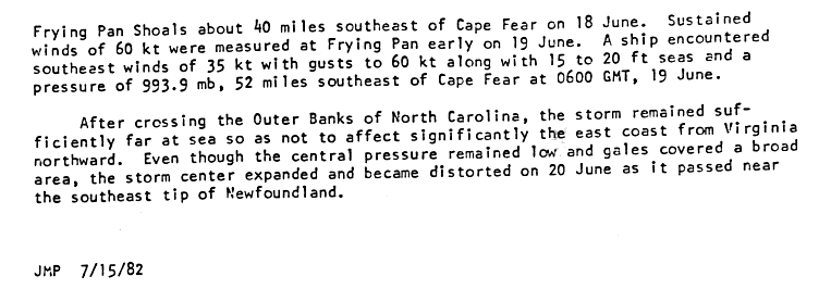
The impact of the storm north of Florida was minor. Rainfall ranged up to 230 mm in the far east of South Carolina and up to 100 mm in North Carolina . The wind speed was up to 60 km / h, with gusts of up to 100 km / h at the coast guard station Oak Island near Cape Fear , North Carolina and 87 km / h with gusts of 123 km / h at the approximately 65 km southeast of Cape Fear offshore lighthouse Frying Pan Shoals on June 18th and sustained winds of 110 km the next day. A 19-meter fishing trawler sank off the coast at Cape Fear, with the crew being rescued by the United States Coast Guard on June 19 . The storm surge reached two to three feet above normal in the Carolina States . In Georgia , rainfall totaled up to 130mm on the coast, with 175mm measured on the South Carolina border. On the coast in Virginia , the amount of rain was a maximum of 25 mm. One ship reported gusts of wind that were just below hurricane strength and waves of 4.5 to 6 m.
Individual evidence
- ^ Paul Herbert: Subtropical Storm One (1974) Preliminary Report ( English , GIF) National Hurricane Center. 1974. Retrieved November 9, 2008.
- ^ A b Joseph M. Pelissier: Subtropical Storm One (1982) Preliminary Report - Section I - Storm History I ( English , GIF) National Hurricane Center. July 15, 1982. Retrieved November 9, 2008.
- ↑ a b c d e Joseph M. Pelissier: Subtropical Storm One (1982) Preliminary Report - Section 2 - Storm History II + Impact ( English , GIF) National Hurricane Center. July 15, 1982. Retrieved November 9, 2008.
- ^ Joseph M. Pelissier: Subtropical Storm One (1982) Preliminary Report - Section 7 - Meteorological stats chart ( English , GIF) National Hurricane Center. July 15, 1982. Retrieved November 9, 2008.
- ↑ Canadian Hurricane Center : Canadian Hurricane Center Report ( English ) Canadian Hurricane Center. July 15, 1982. Retrieved November 9, 2008.
- ^ Joseph M. Pelissier: Subtropical Storm One (1982) Preliminary Report - Section 3 - Storm History + Impact II ( English , GIF) National Hurricane Center. July 15, 1982. Retrieved November 9, 2008.
- ^ A b c Joseph M. Pelissier: Subtropical Storm One (1982) Preliminary Report - Section 4 - Warnings / Watches ( English , GIF) National Hurricane Center. July 15, 1982. Retrieved November 9, 2008.
- ↑ Instituto Nacional de Recursos Hidráulicos: Lluvias intensas observadas y grandes inundaciones reportadas ( Spanish ) 2003. Archived from the original on July 23, 2011. Info: The archive link has been inserted automatically and has not yet been checked. Please check the original and archive link according to the instructions and then remove this notice. Retrieved November 9, 2008.
- ↑ Florida Department of Environmental Protection: Strategic Beach Management Plan ( English , PDF) 2003. Archived from the original on June 9, 2011. Information: The archive link was automatically inserted and not yet checked. Please check the original and archive link according to the instructions and then remove this notice. Retrieved November 9, 2008.
- ^ A b Gilbert B. Clark: 1982 Monthly Weather Review ( English , PDF; 1.0 MB) American Meteorological Society. 1982. Retrieved November 9, 2008.
- ↑ a b David Roth : Rainfall Totals: Subtropical Storm One (1982) ( English ) Hydrometeorological Prediction Center. 2006. Retrieved November 9, 2008.
- ↑ Tom Grazulis of The Tornado Project and Bill McCaul of USRA Huntsville: List of Known Tropical Cyclones Which Have Spawned Tornadoes ( English ) Tornado Project. 2007. Retrieved November 12, 2007.