Sula (Norway)
| coat of arms | map | |
|---|---|---|

|
|
|
| Basic data | ||
| Commune number : | 1531 | |
| Province (county) : | Møre and Romsdal | |
| Administrative headquarters: | Langevåg | |
| Coordinates : | 62 ° 25 ' N , 6 ° 12' E | |
| Surface: | 58.51 km² | |
| Residents: | 9,310 (Feb 27, 2020) | |
| Population density : | 159 inhabitants per km² | |
| Language form : | Nynorsk | |
| Website: | ||
| politics | ||
| Mayor : | Jim Arve Røssevoll ( Ap ) (2015) | |
| Location in the province of Møre og Romsdal | ||

|
||
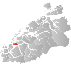
is aNorwegian municipalityin the province (Fylke)Møre og Romsdal. The area is formed by the main island of the same name,Sula,and some offshorearchipelago islands(e.g.Eltraskjeret) and is surrounded by Breisundet in the west,Storfjordand Vartdalsfjorden in the south and Hessafjorden and Borgundfjorden in the north. In the east the main island is bounded by the narrow Vegsundet, a bridge leads over this waterway. Rocks and heather dominate the landscape, the forest is sparse. The highest point measures 776 meters. The neighboring municipalities are separated from Sula by the sea:Hareidin the west,Ørstain the south,Giskein the north-west andÅlesundin the north and east.
Districts
The administrative center is Langevåg . Other settlements are Solevåg, Fiskarstrand, Veibust and Mauseidvåg.
Famous sons and daughters
- Nils Petter Molvær (* 1960), musician
Individual evidence
