Tablelands Highway
| Tablelands Highway | ||||||||||||||||||||||||||||||||||
|---|---|---|---|---|---|---|---|---|---|---|---|---|---|---|---|---|---|---|---|---|---|---|---|---|---|---|---|---|---|---|---|---|---|---|

|
||||||||||||||||||||||||||||||||||
| map | ||||||||||||||||||||||||||||||||||
| Basic data | ||||||||||||||||||||||||||||||||||
| Operator: | NT Roads | |||||||||||||||||||||||||||||||||
| Start of the street: |
Barkly Homestead ( NT ) ( 19 ° 43 ′ S , 135 ° 50 ′ E ) |
|||||||||||||||||||||||||||||||||
| End of street: |
Cape Crawford ( NT ) ( 16 ° 41 ′ S , 135 ° 44 ′ E ) |
|||||||||||||||||||||||||||||||||
| Overall length: | 379 km | |||||||||||||||||||||||||||||||||
|
States : |
||||||||||||||||||||||||||||||||||
|
Course of the road
|
||||||||||||||||||||||||||||||||||
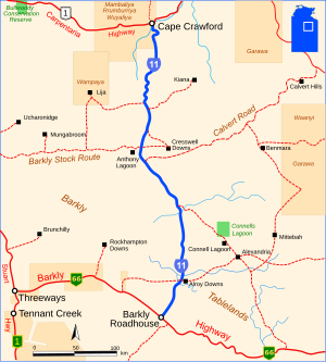
The Tablelands Highway is a trunk road east of the Australian Northern Territory . It connects the Barkly Highway (N66) at Barkly Homestead with the Carpentaria Highway (R1) at Cape Crawford .
course
The road runs through the Barkly Tableland in a south-north direction. The flat, warm plateau has hardly any rivers and streams that seep away again after a few hundred kilometers. One of these rivers is the Playford River on the southern section of the Tablelands Highway. The McArthur River in the northernmost section of the road, however, finds its way north into the Gulf of Carpentaria .
The dry grassland is mainly used for sheep breeding and so the Tablelands Highway connects the few stations on its 379 km long route. There are no larger settlements between Barkly Homestead and Cape Crawford.
The highest point on the highway is 287 m, the lowest is 79 m.
The road is two-lane and paved along its entire length.
source
Steve Parish: Australian Touring Atlas . Steve Parish Publishing. Archerfield QLD 2007. ISBN 978-1-74193-232-4 . P. 99
Individual evidence
- ↑ maps.bonzle.com - Tablelands Highway . Retrieved April 19, 2012.

