Tarka valley
|
Tarka Valley vallée de la Tarka |
||
|
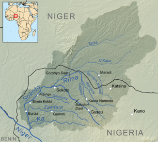
Map of the Sokoto basin with the Tarka Valley to the north |
||
| Data | ||
| location |
|
|
| River system | Niger | |
| Drain over |
Rima → Sokoto → Niger → Gulf of Guinea
|
|
| length | approx. 300 km | |
| Catchment area | 47,998 km² | |
| Big cities | Madaoua | |


The Tarka Valley ( French vallée de la Tarka ), or the Tarka for short ( French la Tarka ), is a West African dry valley that is mainly in Niger and a small part in Nigeria .
Course and characteristics
The Tarka Valley has its origin in the Damergou landscape in the north of the Tanout department in Niger, and in foothills in the Agadez region in northern Niger . Its catchment area in the regions of Agadez, Maradi , Tahoua and Zinder extends over an area of 47,998 km². The dry valley runs over a total length of about 300 km first to the west, then to the south. In the state of Sokoto, shortly after the state border with Nigeria, it flows together with the dry valley Goulbi N'Kaba into the river Rima , a tributary of the river Sokoto .
The valley is hydrologically divided into three sections:
- The upper valley, located in the departments of Belbédji and Tanout, is the most extensive section. It runs from east to west. The larger villages in the upper valley include Gangara , Sabon Kafi and Belbédji . Side valleys are the kori (dry valley) of Damergou and the valley of Belbédji.
- The middle valley stretches from the department of Dakoro to the department of Bouza , still running east-west . Significant villages in this section are Goula , Roumbou , Azagor , Korahane and Karofane . The valley here reaches a width of about six kilometers. Coming from the north and south of the valley of Keita there are a few occasionally water-bearing dry valleys that flow into the Tarka valley.
- The lower valley begins in the Bouza department in the north and extends over the Madaoua department in the south to Nigeria. Larger settlements in this section are Gandassamou , Madaoua , Tounfafi and Sabon-Guida . To the right rises the Ader Doutchi mountain range , from which several side valleys flow. On the left there is a wide sandy plain. The relief in the lower valley is characterized by sandy terraces deformed by the wind.
Not water-bearing for most of the year, flooding in the Tarka Valley can be difficult to predict during the rainy season. In some places permanent ponds ( mares ) remain. 30,000 to 20,000 years ago, the Tarka was still a wetland river that dried up and silted up 20,000 to 12,000 years ago. Gum arabic trees , umbrella acacias and desert dates thrive on the red, sandy-loamy soil in the valley . Anabrees , Bauhinien , Doum palms and Seyal acacias also grow here . The unpredictability of the climate and human activities lead to an increasingly poor state of flora.
Settlement history
The name Tarka comes from the Tamascheq language and means something like “something so fertile that it rots in the end” or “an abundance of trees and pastureland”. In the local tradition, the Tarka is a former river whose sources were in the Libyan Tibesti . Another Tamascheq name in Damergou in the upper valley is Anouwar , which means "watercourse".
Modern settlement of the Tarka Valley began in the 1920s when cattle herders and arable farmers poured into the valley, which at the time had even greater biodiversity . The first camps probably date from this time. The extensive Tarka Valley was not under any traditional rule from pre-colonial times. This fact made it the immigrant Tuareg - and Fulani - nomads initially easy to evade even the clutches of the colonial administration.
The excessive agricultural use caused the deterioration of natural resources. As early as 1937, when permanent settlements had already emerged, the French colonial administration at the time tried to prevent this development in order to protect the pasture areas. The commander of Tanout County, Maurice Vilmin, designated the Tarka Valley by decree in 1947 as a zone for grazing only. In view of the advancing agricultural use, a northern limit was established in 1956, up to which plant cultures were permitted. After Niger gained independence, this provision was adopted in 1961 by a law in which arable farmers were banned from settling across the northern border.
Agricultural use
The iron- soaked soils make the Tarka Valley attractive to arable farmers, while cattle breeders are attracted by the quality of the pasture land. Wells rarely need to be dug deeper than fifty meters. In the rainy season and during supply shortages, the valley is a destination for shepherds from Nigeria and the regions of Agadez, Zinder and South Maradi. The herds stay here for a period of two to three months a year, often longer. In the northern parts there are natural pastures not yet restricted by arable farming, as well as increasingly dwindling wood resources.
The lower valley is one of the most important agricultural areas in Central Niger. In this section, the intensively practiced onion cultivation is particularly important because it offers the farmers an important source of income. The irrigation of maize, sorghum and ( tuber ) vegetables is also typical of the lower valley .
literature
- Alou Abdoul Azibou: Diagnostic et relance de la production fruitière dans la basse vallée de la Tarka . Faculté d'Agronomie, Université Abdou Moumouni, Niamey 1994.
- Moustapha Hiya Maidawa: Enjeux fonciers et stratégies d'acteurs dans la moyenne vallée de la Tarka (Dakoro / Niger) . Mémoire. Université Abdou Moumouni de Niamey, Niamey 2011 ( memoireonline.com ).
- Habibou Ibrahim: Etude de l'émergence des organizations pastorales et de leur rôle dans les processus de gestion partagée de la vallée de la Tarka dans les départements de Bermo et Dakoro (Center sud du Niger) . Thèse de doctorat en sciences. Faculté des Sciences, Université de Liège, Liège 2016 ( orbi.uliege.be [PDF]).
- Bertrand Roger: Etude morphopédologique de la vallée de la Tarka en vue du développement hydroagricole. Possibilities agro-sylvo-pastorales . BRGM, Paris 1980.
- Mohamed Ali Youssoufa: Analysis technico-économique des résultats des périmètres irrigués dans la vallée de la Tarka . Faculté d'Agronomie, Université Abdou Moumouni, Niamey 1996.
Individual evidence
- ↑ a b c d e Le Zonage Agro-écologique du Niger. (PDF) République du Niger, Comité Interministériel de Pilotage de la Stratégie de Développement Rural, Secrétariat Exécutif, 2004, pp. 7–8 and 11 , accessed on September 18, 2018 (French).
- ↑ a b c d e f g h Habibou Ibrahim: Etude de l'émergence des organizations pastorales et de leur rôle dans les processus de gestion partagée de la vallée de la Tarka dans les départements de Bermo et Dakoro (Center sud du Niger) . Thèse de doctorat en sciences. Faculté des Sciences, Université de Liège, Liège 2016, p. 46–47 ( orbi.uliege.be [PDF; accessed September 18, 2018]).
- ↑ a b c d François Fauquet: Dynamiques des ressources environnementales et mutations des systèmes agro-stylo-pastoraux en milieu tropical semi-aride: le cas de la vallée d'Arewa (Niger Central) . Thèse de doctorat en geographie. Université Joseph Fourier de Grenoble I, Grenoble 2005, p. 48 ( biw.kuleuven.be [PDF; accessed on September 18, 2018]).
- ↑ a b c d e f g Moustapha Hiya Maidawa: Enjeux fonciers et stratégies d'acteurs dans la moyenne vallée de la Tarka (Dakoro / Niger) . Mémoire. Université Abdou Moumouni de Niamey, Niamey 2011, p. 20–22 ( memoireonline.com [accessed September 18, 2018]).
- ^ François Fauquet: Dynamiques des ressources environnementales et mutations des systèmes agro-stylo-pastoraux en milieu tropical semi-aride: le cas de la vallée d'Arewa (Niger Central) . Thèse de doctorat en geographie. Université Joseph Fourier de Grenoble I, Grenoble 2005, p. 3 ( biw.kuleuven.be [PDF; accessed on September 18, 2018]).
