Villamejil
| Villamejil municipality | ||
|---|---|---|
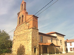
 Villamejil - the village with a church
|
||
| coat of arms | Map of Spain | |

|
|
|
| Basic data | ||
| Autonomous Community : |
|
|
| Province : | Leon | |
| Comarca : | La Cepeda (Leon) | |
| Coordinates | 42 ° 34 ′ N , 6 ° 1 ′ W | |
| Height : | 912 msnm | |
| Area : | 78.98 km² | |
| Residents : | 687 (Jan. 1, 2019) | |
| Population density : | 8.7 inhabitants / km² | |
| Postal code : | 24711 | |
| Municipality number ( INE ): | 24214 | |
| administration | ||
| Website : | Villamejil | |
Villamejil is a northern Spanish city and one of several villages (aldeas) and hamlets (Pedanías) existing municipality ( municipio ) with 687 inhabitants (at January 1, 2019) in the province of León in the autonomous community of Castile and Leon .
Location and climate
The villages of the municipality of Villamejil are located in a swampy area with numerous short streams (arroyos) on the Río Tuerto at an altitude of approx. 915 m in the Leonese plateau ( meseta ) or (vega ). The distance to the small town of Astorga is about 7.5 to 20 km (driving distance) in a southerly direction; to León it is almost 50 km in an easterly direction. The climate is temperate to warm; Rain (approx. 605 mm / year) falls mainly in the winter half-year.
Population development
| year | 1857 | 1900 | 1950 | 2000 | 2018 |
| Residents | 1,248 | 1,435 | 2.147 | 993 | 696 |
Due to the increasing mechanization of agriculture and the abandonment of numerous small farms in the second half of the 20th century, more and more jobs were lacking, which triggered an ongoing rural exodus. The municipality also includes the villages or hamlets Castrillo de Cepeda , Cogorderos , Fontoria de Cepeda , Quintana de Fon , Revilla and Sueros de Cepeda .
economy
The town's traditional main livelihood is agriculture - grain thrives, but also fruits and vegetables that are grown on irrigated land; milk and meat production are also not insignificant. Many vacant houses have been converted into holiday apartments (casas rurales) .
history
The age of the places is unclear - some assume an already Asturian settlement; others see the Romans residing in Astorga (Asturica Augusta) as the first settlers. Archaeological traces - also from Visigoths and Moors - are missing, however. It was not until the Middle Ages that the individual villages developed, but it was not until much later that they were merged into one community. One of the most important cattle driving routes in Spain ( cañadas ) led through the swampy valley of the Río Tuerto .
Attractions
- Villamejil
- The late medieval parish church of San Benito is dedicated to St. Benedict of Nursia († 547) consecrated; However, only the lower part of the west façade, which is divided into two by the stone material, is still original; the bell gable (espadaña) was later renewed or added. The portal on the south side is protected by a porch ( portico ) . Only the tabernacle of the baroque altarpiece (retablo), which is currently being restored, is in the chancel of the church.
- In the square in front of the church there is a modern stone figure of St. Benedict.
- Fontoria de Cepeda
- The church of Fontoria de Cepeda has a remarkable artesonado wooden ceiling.
Web links
Individual evidence
- ↑ Cifras oficiales de población resultantes de la revisión del Padrón municipal a 1 de enero . Population statistics from the Instituto Nacional de Estadística (population update).
- ↑ Villamejil - population development
- ^ Villamejil story
- ↑ Villamejil Church
- ↑ Fontoria de Cepeda - Church
