Posada de Valdeón
| Posada de Valdeón municipality | ||
|---|---|---|
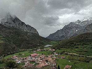
 Posada de Valdeón with Picos de Europa
|
||
| coat of arms | Map of Spain | |

|
|
|
| Basic data | ||
| Autonomous Community : |
|
|
| Province : | Leon | |
| Comarca : | Montaña Oriental | |
| Coordinates | 43 ° 9 ′ N , 4 ° 55 ′ W | |
| Height : | 927 msnm | |
| Area : | 164.60 km² | |
| Residents : | 415 (Jan. 1, 2019) | |
| Population density : | 2.52 inhabitants / km² | |
| Postal code : | 24915 | |
| Municipality number ( INE ): | 24116 | |
| administration | ||
| Website : | Posada de Valdeón | |
Posada de Valdeón is a northern Spanish town and municipality ( municipio ) with 415 inhabitants (as of January 1, 2019) in the province of León in the autonomous community of Castile-León .
location
The seven villages of the municipality of Posada de Valdeón ( Caín de Valdeón , Santa Marina de Valdeón , Caldevilla de Valdeón , Cordiñanes de Valdeón , Los Llanos de Valdeón , Prada de Valdeón and Soto de Valdeón ) are located on the upper reaches of the Río Cares in the Picos de Europa National Park at heights of approx. 850 to 930 meters above sea level. d. M. in the extreme northeast of the province of León. The provincial capital León is located about 135 kilometers (driving distance) to the southwest. The Biscay coast near Ribadesella ( Asturias ) is about 86 kilometers to the north (30 kilometers as the crow flies).
Population development
| year | 1960 | 1970 | 1981 | 1991 | 2001 | 2014 |
| Residents | 1,193 | 1,062 | 736 | 548 | 492 | 464 |
In the 19th century the population of the community rose from around 650 to almost 1,200 people; in the 1950 census it was found with almost 1,300 people. However, due to the increasing mechanization of agriculture in the second half of the 20th century, more and more jobs disappeared, which triggered an ongoing rural exodus.
economy
Traditionally, the main occupation of the inhabitants of the Valdeón high valley, who lived largely as self-sufficient , was agriculture and primarily cattle breeding. Since the 1960s tourism has played an increasingly important role in the municipality's economic life; Signposted hiking trails have been set up and many vacant houses have been converted into holiday apartments ( casas rurales ).
history
The age of the place is unclear - it can be assumed that the high valley was first explored by hunters and later by shepherds. In any case, the Celts , Romans, Visigoths and Moors left no traces on the municipal area. Only in the course of the repopulation ( repoblación ) of the region did the various mountain villages develop; The existence of a church ( Santa Eulalia ) and a monastery ( San Sebastián ) is documented for the 11th century .
Attractions
- Most of the medieval churches have disappeared - only the church in the hamlet of Caín , which may have been built from rubble stones in the 14th century , still stands. The compact building has a bell gable ( espadaña ).
- Inside the parish church ( Iglesia de Santa Eulalia ), which was newly built in the 16th century , is the Romanesque baptismal font ( pila bautismal ) of the previous building.
- Several small storage buildings ( hórreos ) with stone plinths and wooden superstructures are spread across the municipality.
Web links
Individual evidence
- ↑ Cifras oficiales de población resultantes de la revisión del Padrón municipal a 1 de enero . Population statistics from the Instituto Nacional de Estadística (population update).

