White Rock Township (Illinois)
| White Rock Township | ||
|---|---|---|
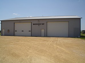
 White Rock Township Building in Kings |
||
| Location in Illinois | ||
|
|
||
| Basic data | ||
| Foundation : | 1849 | |
| State : | United States | |
| State : | Illinois | |
| County : | Ogle County | |
| Coordinates : | 42 ° 1 ′ N , 89 ° 7 ′ W | |
| Time zone : | Central ( UTC − 6 / −5 ) | |
| Residents : | 738 (as of 2010) | |
| Population density : | 8 inhabitants per km 2 | |
| Area : | 92.2 km 2 (about 36 mi 2 ) | |
| Height : | 270 m | |
| Postal code : | 61068 | |
| Area code : | +1 815 | |
| FIPS : | 17-81399 | |
| GNIS ID : | 429931 | |
| Mayor : | John Greenfield (supervisor) | |
 Location of White Rock Township in Ogle County |
||
The White Rock Township is one of 24 townships in Ogle County in the north of the US -amerikanischen state of Illinois .
geography
The White Rock Township is located in northern Illinois. Chicago is around 130 km east-southeast, the border with Wisconsin around 60 km north and the Mississippi , which forms the border with Iowa , around 90 km west.
The White Rock Township is located at 42 ° 00'49 "north latitude and 89 ° 06'34" west longitude and extends over 92.2 km².
The White Rock Township is located in the middle east of Ogle County and borders on the Scott Township in the north, the Monroe Township in the northeast, the Lynnville Township in the east, the Dement Township in the southeast, the Flagg Township in the south and the Southwest to Pine Rock Township and to the northwest to Marion Township .
traffic
In the east of White Rock Township, Illinois State Route 64 , which runs in east-west direction, and Illinois State Route 251, which runs in north-south direction, cross . All other roads are county highways as well as further subordinate and partly unpaved roads.
Parallel to State Route 251 runs a railway line of the Illinois Railway in a north-south direction from Rockford to the Rochelle railway junction in the neighboring Flagg Township to the south.
The nearest airport is Rochelle Municipal Airport , 10 km south of the township ; the nearest major airport is Chicago Rockford International Airport, around 15 km north of the township, on the southern outskirts of Rockford.
population
At the 2010 census , the township had 3,181 inhabitants. In addition to scattered settlements, the following ( non-parish ) settlements exist in the White Rock Township :
1 - mostly in Scott Township
Individual evidence
- ↑ Distance information according to Google Maps. Accessed on May 29, 2012
- ↑ Missouri Census Data Center - Illinois ( page no longer available , search in web archives ) Info: The link was automatically marked as defective. Please check the link according to the instructions and then remove this notice. Retrieved March 3, 2014
