Wiesenhöfe
| Wiesenhöfe (scattered houses) | ||
|---|---|---|
|
|
||
| Basic data | ||
| Pole. District , state | Innsbruck-Land (IL), Tyrol | |
| Judicial district | innsbruck | |
| Pole. local community | Aldrans | |
| Locality | Aldrans | |
| Coordinates | 47 ° 14 '54 " N , 11 ° 28' 51" E | |
| height | 892 m above sea level A. | |
| Building status | 60 (addresses 2015 ) | |
| Post Code | 6071 Aldrans | |
| Statistical identification | ||
| Counting district / district | Aldrans (70302 000) | |

|
||
| Addresses Rinner Straße Source: STAT : Directory of places ; BEV : GEONAM ; TIRIS |
||
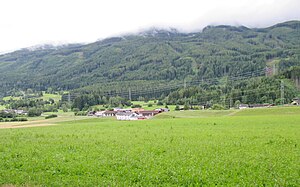
Wiesenhöfe is a location in the south-eastern low mountain range not far from Innsbruck in Tyrol and belongs to the municipality of Aldrans in the Innsbruck-Land district .
geography
The scattered settlement is located south between Innsbruck and Hall, halfway between Aldrans and Rinn , 2 kilometers or 1½ km away on Rinner Straße ( Mittelgebirgsstraße , L 9 ). It lies at around 890 m above sea level. A. Height at the foot of the Patscherkofel .
The location includes around 60 buildings.
Here the Herztalbach runs towards the Ampass.
| Prockenhöfe | ||
|
Branches |

|
Triendlsiedlung (Gem. Rinn ) |
History, infrastructure and sights
The homestead Wiesenhof (house number 31) and the Gasthof Wiesenhof (house number 32) give it its name. The Urhof is already listed in the Atlas Tyrolensis (Anich, Hueber, 1774). The small Wiesenhof chapel is a typical, simpler court chapel from the 18th century. To the east is the Bartenbach house, built between 1975 and 1977 according to plans by Josef Lackner , a wood-master student, a characteristic residential building of classic modernism. The former seed testing institute , which already belongs to the Rinner Triendl settlement (test field), is directly adjacent .
Around 1800 there is a pond between the Asten and the Wiesenhöfen, which the house name Seehütterhof in the Aste probably reminds of. Like the Herzsee below, it may have been a stately fish pond from the early modern era.
Today the area is a residential and leisure area (Innsbruck recreational area). The Patscherkofel cycle path Igls - Judenstein , also part of the Bike Trail Tirol Windegg - Matrei , runs through the village .
Web links
- Föhnsturm challenged the Aldrans fire brigade, operational documentation, Alexander Nairz, Aldrans FF; to the foehn storm 4./5. November 2014 , with photo gallery.
proof
- 70302 - Aldrans. Community data, Statistics Austria .
- ↑ TIRIS address search, as of February 25, 2015.
- ^ Peter Anich, Blasius Hueber, Atlas Tyrolensis, 1774. Layer in TIRIS: Historical maps of Tyrol .
- ↑ Hofkapelle, Wiesenhof Chapel, Wiesenhofkapelle. In: Tyrolean art register . Retrieved November 15, 2015 .
- ↑ Bartenbach residential building, Bartenbach house. In: Tyrolean art register . Retrieved November 15, 2015 .
- ^ Carte du Tyrol, en l'An 9 au Dépôt général de la Guerre et augmentée du Vorarlberg, 1808, scale 1: 140.500, layer in TIRIS: Historical maps of the Tyrol .

