
Wind Cave National Park: Difference between revisions
→Geology: added image |
|||
| (147 intermediate revisions by 87 users not shown) | |||
| Line 1: | Line 1: | ||
{{for|the Romanian cave also known as Wind Cave|Peștera Vântului}} |
|||
{{short description|National park in South Dakota, United States}} |
|||
{{Infobox protected area |
{{Infobox protected area |
||
| name = Wind Cave National Park |
| name = Wind Cave National Park |
||
| Line 4: | Line 6: | ||
| photo = Cave Boxwork often call cratework when this large. WInd Cave.JPG |
| photo = Cave Boxwork often call cratework when this large. WInd Cave.JPG |
||
| photo_caption = Boxwork formation |
| photo_caption = Boxwork formation |
||
| map = USA |
| map = South Dakota#USA |
||
| relief = 1 |
| relief = 1 |
||
| map_caption = |
| map_caption = Location in South Dakota##Location in the United States |
||
| label_position = right |
| label_position = right |
||
| label = Wind Cave |
| label = Wind Cave |
||
| mark = |
| mark = |
||
| location = [[Custer County, South Dakota|Custer County]], [[South Dakota |
| location = [[Custer County, South Dakota|Custer County]], [[South Dakota]], United States |
||
| nearest_city = [[Hot Springs, South Dakota]] |
| nearest_city = [[Hot Springs, South Dakota]] |
||
| coordinates = {{coord|43.55635|-103.47865|format=dms|display=inline, title}} |
| coordinates = {{coord|43.55635|-103.47865|format=dms|display=inline, title}} |
||
| established = January 9, 1903<ref>{{cite web | url=https://www.nps.gov/wica/learn/news/park-celebrates-centennial.htm#:~:text=Wind%20Cave%20National%20Park%20Superintendent%20Linda%20L.%20Stoll,with%20several%20thousand%20visitors%20attending%20the%203-day%20event. | title=Park Celebrates Centennial - Wind Cave National Park (U.S. National Park Service) }}</ref><ref name="wcnp-01">{{cite web |title=Birth of a National Park - A National Park is Created |url=https://home.nps.gov/wica/learn/historyculture/birth-of-a-national-park-a-national-park-is-created.htm |website=Wind Cave National Park |publisher=National Park Service |access-date=15 May 2022}}</ref> |
|||
| established = January 9, 1903 |
|||
| area_acre = 33847 |
| area_acre = 33847 |
||
| area_ref = <ref name="area">{{NPS area|year=2011| |
| area_ref = <ref name="area">{{NPS area|year=2011|access-date=March 7, 2012}}</ref> |
||
| visitation_num = |
| visitation_num = 448,405 |
||
| visitation_year = |
| visitation_year = 2020 |
||
| visitation_ref = <ref name="visits">{{NPS Visitation| |
| visitation_ref = <ref name="visits">{{NPS Visitation|access-date=August 11, 2021}}</ref> |
||
| governing_body = [[National Park Service]] |
| governing_body = [[National Park Service]] |
||
| website = [https://www.nps.gov/wica/ |
| website = [https://www.nps.gov/wica/ Wind Cave National Park] |
||
}}{{Black Hills and Badlands}} |
|||
}} |
|||
''' Wind Cave National Park''' is an American [[national park]] located {{convert|10|mi|km|0}} north of the town of [[Hot Springs, South Dakota|Hot Springs]] in western [[South Dakota]]. Established on January 3, 1903<ref name="wcnp-01" /> by President [[Theodore Roosevelt]], it was the sixth national park in the U.S. and the first [[cave]] to be designated a national park anywhere in the world. The cave is notable for its [[calcite]] formations known as [[boxwork]], as well as its [[frostwork]].<ref>{{Cite web|title=Wind Cave National Park (U.S. National Park Service) |url=https://www.nps.gov/wica/index.htm |access-date=2022-02-26 |website=www.nps.gov |language=en}}</ref> Approximately 95 percent of the world's discovered boxwork formations are found in Wind Cave. |
|||
{{Black Hills and Badlands}} |
|||
[[File:Calcite boxwork, Wind Cave.jpg|thumb|Calcite [[boxwork]] from Wind Cave. This boxwork is the result of differential dissolution of intensely fractured and veined [[limestone]] during cave formation.]] |
|||
[[File:Cave Frostwork and Popcorn-Wind Cave.JPG|thumb|Frostwork and popcorn formations]] |
|||
Wind Cave is one of the best known examples of a [[breathing cave]]. The cave is recognized as the densest cave system in the world, with the greatest passage volume per cubic mile. Wind Cave is the seventh [[List of longest caves|longest cave in the world]] with {{convert|154.2|mi|km|2}} of explored cave passageways ({{as of|2021|lc=y}}) and the third [[List of longest caves in the United States|longest cave in the United States]], though it is only the second longest cave in [[Custer County, South Dakota]] behind [[Jewel Cave National Monument|Jewel Cave]].<ref name="Gulden">{{cite web|last=Gulden|first=Bob|date=April 19, 2021|title=Worlds longest caves|url=http://www.caverbob.com/wlong.htm|access-date=September 4, 2021|work=Geo2 Committee on Long and Deep Caves|publisher=[[National Speleological Society]] (NSS)}}</ref> Despite the close proximity, no connection has ever been found between Wind Cave and Jewel Cave and most geologists believe the caves are not connected.<ref>{{Cite web |title=Esri News -- ArcNews Winter 2002/2003 Issue -- Developing a Cave Potential Map for South Dakota's Wind Cave Using GIS |url=https://www.esri.com/news/arcnews/winter0203articles/developing-a-cave.html |access-date=2024-01-08 |website=www.esri.com}}</ref> Above ground, the park includes the largest remaining natural mixed grass [[prairie]] in the United States. |
|||
== |
==Origin of name== |
||
The passages of the cave are said to "[[Breathing cave|breathe]]" as air continually moves into or out of them, equalizing the [[atmospheric pressure]] of the cave and the outside air. When the air pressure is higher outside the cave than inside it, air flows into the cave, raising the cave's pressure to match the outside pressure. When the air pressure inside the cave is higher than outside it, air flows out of the cave, lowering the air pressure within the cave.<ref name="brochure" /> A large cave such as Wind Cave with only a few small openings will "breathe" more obviously than a small cave with many large openings. |
|||
The [[Lakota people|Lakota]], [[Cheyenne]], and other [[Native Americans in the United States|Native American tribes]] who traveled through the area were aware of the cave's existence, as were early Euro-American settlers, but there has been no evidence yet discovered that anyone actually entered it.<ref name="NPS explorers">[http://www.nps.gov/wica/historyculture/early-cave-explorers.htm National Park Service: Early cave explorers]</ref> |
|||
Rapid weather changes, accompanied by rapid barometric changes, are a feature of western South Dakota weather. If a fast-moving storm was approaching on the day the Bingham brothers found the cave, the atmospheric pressure would have been dropping fast, causing the cave's higher-pressure air to rush out all available openings, creating the wind for which Wind Cave was named. |
|||
The Lakota ([[Sioux]]), an indigenous people who live in the [[Black Hills]] region of South Dakota, spoke of a hole that blew air, a place they consider [[sacred]] as the site where they first emerged from the underworld where they had lived before the [[demiurge]] [[creation myth#Lakota|creation of the world]].<ref name="NPS explorers"/> |
|||
==History== |
|||
The first documented [[Discovery (observation)|discovery]] of the cave by [[White American]]s was in 1881, when the brothers Tom and Jesse Bingham heard wind rushing out from a {{convert|10|in|cm|0|adj=on}} by {{convert|14|in|cm|0|adj=on}} hole in the ground. According to the story, when Tom looked into the hole, the "wind" (exiting cave air) blew his hat off of his head.<ref name="brochure">Wind Cave brochure, National Park Service, GPO, WDC</ref> |
|||
The [[Lakota people|Lakota]], [[Cheyenne]], and other [[Native Americans in the United States|Native American tribes]] who traveled through and made camps around the area were aware of the cave's existence, as were early Euro-American settlers, but there has been no recorded evidence discovered that anyone actually entered it.<ref name="NPS explorers">[http://www.nps.gov/wica/historyculture/early-cave-explorers.htm National Park Service: Early cave explorers]</ref> |
|||
The Lakota ([[Sioux]]), an indigenous people who live in the [[Black Hills]] region of South Dakota, spoke of a hole that blew air, a place they consider [[sacred]] as the site where they first emerged from the underworld where they had lived before the [[demiurge]] [[creation myth#Lakota|creation of the world]].<ref name="NPS explorers"/> Originally called Washun Niya, Wind Cave played an important role in the traditions and culture of the Lakota people.<ref>Fritz, Jessica Garcia, and Federico Garcia Lammers. "ORIGINS FROM WIND CAVE WASHUN NIYA: SACRED SPACE AS CONTESTED TERRITORY." GENIUS LOCI: 33.</ref> The fables of these people tell the story of Tokahe, the first human to emerge from the cave, symbolizing an emergence from the underworld. His story and presence at Wind Cave is an important part of Lakota history, and heavily influences their origin story. |
|||
==Source of cave's name== |
|||
The caves found in the park are said to "breathe," that is, air continually moves into or out of a cave, equalizing the [[atmospheric pressure]] of the cave and the outside air. When the air pressure is higher outside the cave than in it, air flows into the cave, raising cave's pressure to match the outside pressure. When the air pressure inside the cave is higher than outside it, air flows out of it, lowering the air pressure within the cave.<ref name="brochure" /> A large cave (such as Wind Cave) with only a few small openings will "breathe" more obviously than a small cave with many large openings. |
|||
Wind Cave and other areas throughout the Black Hills were important to the native people in other ways beyond spirituality. Nicknamed, euphemistically, as a “supermarket,” the areas surrounding the cave provided abundant resources for native survival. Often during the winter seasons, such areas served as ideal spots for camps; much of the game they hunted preferred the shelter provided by the cave and made these areas ideal to become Lakota settlements and hunting grounds.<ref>{{Cite journal |last1=Albers |first1=Patricia |last2=Berndt |first2=Christina |last3=Brown |first3=Elizabeth |last4=Kelly |first4=Yvonne |last5=Kittelson |first5=Vanessa |last6=Rossina |first6=Kim |last7=Schlegel |first7=Stacy |last8=Yardley |first8=Andrea |date=2003-01-01 |title=The Home of the Bison : An Ethnographic and Ethnohistorical Study of Traditional Cultural Affiliations to Wind Cave National Park |url=https://digitalcommons.unl.edu/natlpark/158 |journal=U.S. National Park Service Publications and Papers}}</ref> |
|||
Rapid weather changes, accompanied by rapid barometric changes, are a feature of Western South Dakota weather. If a fast-moving storm was approaching on the day the Bingham brothers found the cave, the atmospheric pressure would have been dropping fast, causing the cave's higher-pressure air to rush out all available openings, creating the "wind" for which Wind Cave was named. |
|||
The eventual dispossession of the Lakota people followed the consistent history of dispossession of indigenous peoples across the country. In 1851 a [[Treaty of Fort Laramie (1851)|Treaty was formed at Fort Laramie]], entering the tribe into a legal relationship with the U.S. government.<ref name=":2">{{Cite thesis |title=Oníya Ošóka: The Interpretation of Oglála Lakȟóta Continuing and Historical Relational Connections at Wind Cave National Park |url=https://escholarship.org/uc/item/60g1q0r0 |publisher=UCLA |date=2018 |language=en |first=Bear |last=Eagle}}</ref> Another [[Treaty of Fort Laramie (1868)|Treaty of Fort Laramie]] in 1868 redefined and reduced the borders of Lakota land within the Black Hills.<ref name=":2" /> Article two within that treaty allowed for forts to be built within Lakota land and in 1874 General [[George Armstrong Custer|George A. Custer]] began surveying the land and mistakenly reported a significant presence of gold, despite the geologist on his team of surveyors saying there were no quantities of substance.<ref name=":2" /> Miners then began to invade the hills in search of gold, which was against the treaty with the Lakota people, though the government did little to punish such offenses. In 1875 the Lakota title to the land was deemed invalid due to their lack of structural development and supposed “wasting” of the land.<ref name=":2" /> When the [[Dawes Act]] was passed in 1877, the site was opened to settlers and effectively sealed the dispossession of the Lakota from their ancestral lands.<ref name=":2" /> |
|||
==Early exploration and tours== |
|||
From 1881 to 1889, few people ventured far into Wind Cave. Then in 1889 the South Dakota Mining Company hired Jesse D. McDonald to oversee their "mining claim" on the cave site. The South Dakota Mining Company may have hoped to find minerals of value, or it may from the start have had commercial development of the cave in mind.<ref>http://www.nps.gov/wica/historyculture/alvin_mcdonald.htm</ref> |
|||
The first documented [[Discovery (observation)|discovery]] of the cave by [[white Americans]] was in 1881, when the brothers Tom and Jesse Bingham heard wind rushing out from a {{convert|10|in|cm|0|adj=on}} by {{convert|14|in|cm|0|adj=on}} hole in the ground. According to the story, when Tom looked into the hole, the wind exiting the cave blew his hat off of his head.<ref name="brochure">Wind Cave brochure, National Park Service, GPO, WDC</ref> |
|||
No valuable mineral deposits were found, and the McDonald family began developing the cave for tourism. Jesse initially hired his son Alvin (age 16 in 1890) and, beginning in 1891, Alvin's brother Elmer, to explore and help develop the cave.<ref>McDonald, Alvin Frank. A Private Account of A. F. McDonald, Permanent Guide of Wind Cave (a.k.a. "Alvin McDonald Diary," written 1891-1893). Facsimile ed., no pub. data. Sold through Wind Cave National Park. Financial entries, pp. 20-21 and 23-25.</ref> Alvin fell in love with the cave and kept a cave diary.<ref>http://www.nps.gov/wica/historyculture/alvin-mcdonalds-diary-text.htm</ref> Others who worked at Wind Cave and helped explore it between 1890 and 1903 include Katie Stabler, Emma McDonald (Elmer's wife), Inez McDonald (Emma and Elmer's daughter), and Tommy McDonald (brother of Elmer and Alvin).<ref name="NPS explorers"/> |
|||
From 1881 to 1889, few people ventured far into Wind Cave. Then in 1889 the South Dakota Mining Company hired Jesse D. McDonald to oversee their mining claim on the cave site. The South Dakota Mining Company may have hoped to find valuable minerals, or it may have had commercial development of the cave in mind from the start.<ref>{{cite web| url = http://www.nps.gov/wica/historyculture/alvin_mcdonald.htm| url-status = dead| archive-url = https://web.archive.org/web/20070216171023/http://www.nps.gov/wica/historyculture/alvin_mcdonald.htm| archive-date = 2007-02-16| title = Wind Cave National Park - Alvin McDonald (1873-1893) (U.S. National Park Service)}}</ref> |
|||
By February 1892 the cave was open for visitors;<ref>McDonald, Alvin Frank. A Private Account of A. F. McDonald, Permanent Guide of Wind Cave (a.k.a. "Alvin McDonald Diary," written 1891-1893). Facsimile ed., no pub. data. Sold through Wind Cave National Park. Financial entries, p. 9</ref> the standard tour fee was apparently $1.00,<ref>McDonald, Alvin Frank. A Private Account of A. F. McDonald, Permanent Guide of Wind Cave (a.k.a. "Alvin McDonald Diary," written 1891-1893). Facsimile ed., no pub. data. Sold through Wind Cave National Park. Financial entries, p. 8-9</ref> which was a significant sum of money at the time. |
|||
No valuable mineral deposits were found, and the McDonald family began developing the cave for tourism. Jesse initially hired his son Alvin (age 16 in 1890) and, beginning in 1891, Alvin's brother Elmer, to explore and help develop the cave.<ref>McDonald, Alvin Frank. A Private Account of A. F. McDonald, Permanent Guide of Wind Cave (a.k.a. "Alvin McDonald Diary," written 1891–1893). Facsimile ed., no pub. data. Sold through Wind Cave National Park. Financial entries, pp. 20-21 and 23-25.</ref> Alvin fell in love with the cave and kept a cave diary.<ref>{{cite web| url = http://www.nps.gov/wica/historyculture/alvin-mcdonalds-diary-text.htm| title = Alvin McDonald's Diary - Wind Cave National Park (U.S. National Park Service)}}</ref> Others who worked at Wind Cave and helped explore it between 1890 and 1903 include Katie Stabler, Emma McDonald (Elmer's wife), Inez McDonald (Emma and Elmer's daughter), and Tommy McDonald (brother of Elmer and Alvin).<ref name="NPS explorers"/> |
|||
Tourists, with their guide, explored the cave by candlelight. These early tours were physically demanding and sometimes involved crawling through narrow passages. |
|||
By February 1892 the cave was open for visitors;<ref>McDonald, Alvin Frank. A Private Account of A. F. McDonald, Permanent Guide of Wind Cave (a.k.a. "Alvin McDonald Diary," written 1891–1893). Facsimile ed., no pub. data. Sold through Wind Cave National Park. Financial entries, p. 9</ref> the standard tour fee was apparently $1.00<ref>McDonald, Alvin Frank. A Private Account of A. F. McDonald, Permanent Guide of Wind Cave (a.k.a. "Alvin McDonald Diary," written 1891–1893). Facsimile ed., no pub. data. Sold through Wind Cave National Park. Financial entries, p. 8-9</ref> (equivalent to roughly $30 in 2021). Tourists explored the cave by candlelight on guided tours. These early tours were physically demanding and sometimes involved crawling through narrow passages. |
|||
Like the nearby [[Jewel Cave National Monument]], currently the third longest cave, [[Herb and Jan Conn]] played an important role in cave exploration during the 1960s. |
|||
Like the nearby [[Jewel Cave National Monument]], currently the third longest cave in the world, [[Herb and Jan Conn]] played an important role in cave exploration during the 1960s.<ref>{{cite news |last1=Higbee |first1=paul |title=Explorers of an Unseen World |url=https://www.southdakotamagazine.com/explorers-of-an-unseen-world |access-date=2 November 2021 |publisher=South Dakota Magazine |date=January 1998}}</ref> |
|||
==Surface resources== |
|||
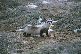
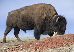
Wind Cave National Park protects a [[Biodiversity|diverse]] [[ecosystem]] with eastern and western plant and animal species. Many visible animals inhabit this park include [[raccoon]]s, [[elk]] (also called ''wapiti''), [[American bison|bison]], [[coyote]]s, [[striped skunk|skunk]]s, [[American badger|badger]]s, [[stoat|ermine]]s, [[black-footed ferret]]s, [[North American cougar|cougar]]s, [[bobcat]]s, [[red fox]]es, [[American mink|mink]]s, [[pronghorn]] and [[prairie dogs]]. The [[Wind Cave bison herd]] is one of only four free-roaming and genetically pure herds on public lands in North America. The other three herds are the [[Yellowstone Park bison herd]], the [[Henry Mountains bison herd]] in [[Utah]] and on Elk Island in [[Alberta, Canada]]. The Wind Cave bison herd is currently [[brucellosis]]-free.<ref name="brochure" /> |
|||
==Flora and fauna== |
|||
Several roads run through the park and there are {{convert|30|mi|km|0}} of hiking trails, so almost the entire park is accessible. The park had an estimated 617,377 visitors in 2016.<ref name="visits" /> More than 109,000 people toured the cave itself in 2015, the most since 1968 before cave tours were limited to 40 people each.<ref>{{cite web | website = [[South Dakota Public Broadcasting]] | last = Kent | first = Jim | date = January 19, 2016 | accessdate = January 19, 2016 | url = http://listen.sdpb.org/post/wind-cave-numbers-highest-40-years | title = Wind Cave Numbers Highest In 40 Years }}</ref> |
|||
[[File:A556, Wind Cave National Park, South Dakota, USA, 2001.jpg|thumb|left|A [[American bison|bison]] scratches against the stone base of a park sign.]] |
|||
Wind Cave National Park protects a [[Biodiversity|diverse ecosystem]] with eastern and western plant and animal species. Wildlife that inhabits this park include [[raccoon]]s, [[elk]], [[American bison|bison]], [[coyote]]s, [[striped skunk|skunk]]s, [[American badger|badger]]s, [[stoat|ermine]]s, [[black-footed ferret]]s, [[North American cougar|cougar]]s, [[bobcat]]s, [[red fox]]es, [[American mink|mink]]s, [[whooping crane]], [[pronghorn]] and [[prairie dogs]]. The [[Wind Cave bison herd]] is one of only four free-roaming and genetically pure herds on public lands in North America. The other three herds are the [[Yellowstone Park bison herd]], the [[Henry Mountains bison herd]] in [[Utah]], and on Elk Island in [[Alberta, Canada]]. The Wind Cave bison herd is currently [[brucellosis]]-free.<ref name="brochure" /> |
|||
=== Endangered species === |
|||
The Wind Cave Visitor Center features three exhibit rooms about the [[geology]] of the caves and early cave history, the park's wildlife and natural history, and the work of the [[Civilian Conservation Corps]] in the park. |
|||
<gallery mode="packed-overlay"> |
|||
File:Grus americana Sasata.jpg|Whooping Crane |
|||
File:Black footed ferret whole.jpg|Black-footed ferret |
|||
</gallery> |
|||
The black-footed ferret and whooping crane are on the endangered species list.<ref>{{Cite web |title=Map of threatened and endangered species in National Parks |url=https://esa.npca.org/map/ |access-date=2022-04-18 |website=Wildlife and Wild Lands |language=en}}</ref><ref name=":1">{{Cite web |title=ECOS: Species Profile |url=https://ecos.fws.gov/ecp/species/758 |access-date=2022-04-18 |website=ecos.fws.gov}}</ref> The whooping crane population in Wind Cave National Park is considered a non-self-sustaining wild population.<ref name=":1" /> |
|||
Elk Mountain Campground, located in a [[Pinus ponderosa|ponderosa pine]] forest, is about {{convert|1.25|mi|km|1}} from the visitor center. There are 75 sites for tents and recreational vehicles. It is open year-round with campfire programs offered in the summer and limited services available in the winter.<ref name="brochure" /> As of March 2013, the campground has been closed due to budget cuts stemming from [[Budget sequestration in 2013|the United States budget sequestration]] law. However, the decision to close the campground was reversed, and it has been available since May 24, 2013.<ref>{{cite news | first = Mary | last = Garrigan | title = Elk Mountain campground reopens May 24 | date = 8 May 2013 | url = http://rapidcityjournal.com/news/elk-mountain-campground-reopens-may/article_2667017a-a261-554b-9453-92137abb2775.html | work = Rapid City Journal | accessdate = 2013-06-12}}</ref> |
|||
== |
==Climate== |
||
{{Weather box|width=auto |
|||
[[File:NPS Wind Cave NP Geologic Map.png|thumb|left|The green boundary marks the southern portion of Wind Cave National Park. This [[geologic map]] shows where the Mississippian Pahasapa (Madison) Limestone, Mp, and the Pennsylvanian Minnelusa [[formation (geology)|Formation]], Phm, [[outcrop]]s.]] |
|||
|location = Wind Cave, South Dakota (1991–2020 normals, extremes 1990–present) |
|||
The three levels making up the Wind Cave system are located in the upper 76 m of the [[Mississippian (geology)|Mississippian]] Pahasapa (Madison) [[Limestone]]. Deposited in an inland sea, [[chert]], [[gypsum]], and [[anhydrite]] [[lens (geology)|lenses]] within the limestone are evidence of high periods of evaporation.<ref name="KellerLynn">{{cite book|last1=KellerLynn|first1=K.|title=Wind Cave National Park Geologic Resources Inventory Report, Natural Resource Report NPS/NRPC/GRD/NRR-2009/087|date=2009|publisher=National Park Service|location=Denver|pages=14-15,29}}</ref> |
|||
|single line = Y |
|||
| Jan record high F = 69 |
|||
| Feb record high F = 69 |
|||
| Mar record high F = 77 |
|||
| Apr record high F = 89 |
|||
| May record high F = 92 |
|||
| Jun record high F = 102 |
|||
| Jul record high F = 105 |
|||
| Aug record high F = 101 |
|||
| Sep record high F = 103 |
|||
| Oct record high F = 89 |
|||
| Nov record high F = 76 |
|||
| Dec record high F = 66 |
|||
| year record high F = 105 |
|||
|Jan avg record high F = 57.5 |
|||
|Feb avg record high F = 57.7 |
|||
|Mar avg record high F = 69.3 |
|||
|Apr avg record high F = 77.3 |
|||
|May avg record high F = 84.6 |
|||
|Jun avg record high F = 91.8 |
|||
|Jul avg record high F = 96.0 |
|||
|Aug avg record high F = 94.7 |
|||
|Sep avg record high F = 91.3 |
|||
|Oct avg record high F = 79.7 |
|||
|Nov avg record high F = 67.2 |
|||
|Dec avg record high F = 56.9 |
|||
|year avg record high F = 97.7 |
|||
| Jan high F = 39.7 |
|||
| Feb high F = 40.7 |
|||
| Mar high F = 50.0 |
|||
| Apr high F = 57.7 |
|||
| May high F = 66.4 |
|||
| Jun high F = 77.4 |
|||
| Jul high F = 84.7 |
|||
| Aug high F = 83.6 |
|||
| Sep high F = 76.2 |
|||
| Oct high F = 61.4 |
|||
| Nov high F = 48.4 |
|||
| Dec high F = 39.4 |
|||
| year high F = 60.5 |
|||
| Jan mean F = 27.2 |
|||
| Feb mean F = 28.1 |
|||
| Mar mean F = 36.8 |
|||
| Apr mean F = 44.3 |
|||
| May mean F = 53.7 |
|||
| Jun mean F = 63.8 |
|||
| Jul mean F = 70.7 |
|||
| Aug mean F = 69.2 |
|||
| Sep mean F = 61.2 |
|||
| Oct mean F = 47.7 |
|||
| Nov mean F = 35.9 |
|||
| Dec mean F = 27.4 |
|||
| year mean F = 47.2 |
|||
| Jan low F = 14.8 |
|||
| Feb low F = 15.5 |
|||
| Mar low F = 23.7 |
|||
| Apr low F = 30.9 |
|||
| May low F = 40.9 |
|||
| Jun low F = 50.1 |
|||
| Jul low F = 56.6 |
|||
| Aug low F = 54.9 |
|||
| Sep low F = 46.2 |
|||
| Oct low F = 34.0 |
|||
| Nov low F = 23.4 |
|||
| Dec low F = 15.4 |
|||
| year low F = 33.9 |
|||
|Jan avg record low F = -9.6 |
|||
|Feb avg record low F = -8.3 |
|||
|Mar avg record low F = 1.2 |
|||
|Apr avg record low F = 14.6 |
|||
|May avg record low F = 26.0 |
|||
|Jun avg record low F = 37.6 |
|||
|Jul avg record low F = 45.8 |
|||
|Aug avg record low F = 42.8 |
|||
|Sep avg record low F = 31.5 |
|||
|Oct avg record low F = 15.1 |
|||
|Nov avg record low F = 1.5 |
|||
|Dec avg record low F = -7.2 |
|||
|year avg record low F = -18.2 |
|||
| Jan record low F = -30 |
|||
| Feb record low F = -32 |
|||
| Mar record low F = -20 |
|||
| Apr record low F = 1 |
|||
| May record low F = 15 |
|||
| Jun record low F = 30 |
|||
| Jul record low F = 38 |
|||
| Aug record low F = 31 |
|||
| Sep record low F = 23 |
|||
| Oct record low F = -2 |
|||
| Nov record low F = -15 |
|||
| Dec record low F = -27 |
|||
| year record low F = -32 |
|||
|precipitation colour = green |
|||
| Jan precipitation inch = 0.45 |
|||
| Feb precipitation inch = 0.70 |
|||
| Mar precipitation inch = 1.07 |
|||
| Apr precipitation inch = 2.32 |
|||
| May precipitation inch = 3.74 |
|||
| Jun precipitation inch = 3.29 |
|||
| Jul precipitation inch = 3.01 |
|||
| Aug precipitation inch = 2.30 |
|||
| Sep precipitation inch = 1.53 |
|||
| Oct precipitation inch = 1.55 |
|||
| Nov precipitation inch = 0.71 |
|||
| Dec precipitation inch = 0.53 |
|||
| year precipitation inch = 21.20 |
|||
| Jan snow inch = 6.3 |
|||
| Feb snow inch = 7.1 |
|||
| Mar snow inch = 9.6 |
|||
| Apr snow inch = 7.8 |
|||
| May snow inch = 0.9 |
|||
| Jun snow inch = 0.0 |
|||
| Jul snow inch = 0.0 |
|||
| Aug snow inch = 0.0 |
|||
| Sep snow inch = 0.2 |
|||
| Oct snow inch = 2.1 |
|||
| Nov snow inch = 4.4 |
|||
| Dec snow inch = 7.5 |
|||
| year snow inch = 45.9 |
|||
| unit precipitation days = 0.01 in |
|||
| Jan precipitation days = 4.5 |
|||
| Feb precipitation days = 5.8 |
|||
| Mar precipitation days = 6.0 |
|||
| Apr precipitation days = 9.4 |
|||
| May precipitation days = 11.2 |
|||
| Jun precipitation days = 11.4 |
|||
| Jul precipitation days = 9.7 |
|||
| Aug precipitation days = 8.5 |
|||
| Sep precipitation days = 6.3 |
|||
| Oct precipitation days = 7.0 |
|||
| Nov precipitation days = 4.1 |
|||
| Dec precipitation days = 3.8 |
|||
| year precipitation days = 87.7 |
|||
| unit snow days = 0.1 in |
|||
| Jan snow days = 3.9 |
|||
| Feb snow days = 4.9 |
|||
| Mar snow days = 3.5 |
|||
| Apr snow days = 2.8 |
|||
| May snow days = 0.5 |
|||
| Jun snow days = 0.0 |
|||
| Jul snow days = 0.0 |
|||
| Aug snow days = 0.0 |
|||
| Sep snow days = 0.1 |
|||
| Oct snow days = 1.1 |
|||
| Nov snow days = 2.7 |
|||
| Dec snow days = 3.6 |
|||
| year snow days = 23.1 |
|||
| source 1 = NOAA<ref>{{cite web |
|||
| url = https://w2.weather.gov/climate/xmacis.php?wfo=unr |
|||
| title = NOWData – NOAA Online Weather Data |
|||
| publisher = [[National Oceanic and Atmospheric Administration]] |
|||
| access-date = June 12, 2021}}</ref><ref>{{cite web |
|||
| url = https://www.ncei.noaa.gov/access/services/data/v1?dataset=normals-monthly-1991-2020&startDate=0001-01-01&endDate=9996-12-31&stations=USC00399347&format=pdf |
|||
| title = Summary of Monthly Normals 1991–2020 |
|||
| publisher = [[National Oceanic and Atmospheric Administration]] |
|||
| access-date = June 12, 2021}}</ref> |
|||
}}Throughout the years, the [[Great Plains|great plains]] have seen a considerable rise in temperature. Being that Wind Cave is located in the great plains, these temperature rises have already started to affect the park and the area around it.<ref name=":0">{{Cite web|title=Climate Change - Wind Cave National Park (U.S. National Park Service) |url=https://www.nps.gov/wica/learn/nature/climate-change-impacts-of-warming-on-the-great-plains.htm |access-date=2022-02-26 |website=www.nps.gov |language=en}}</ref> The average [[Climate change|temperature rise]] across the plains has been two degrees Fahrenheit, with some areas seeing increases as high as five degrees Fahrenheit.<ref name=":0" /> This trend is projected to cause [[drought]] like conditions in the area.<ref name=":0" /> |
|||
==Infrastructure== |
|||
Several roads run through the park and there are {{convert|30|mi|km|0}} of hiking trails on the surface. The park had an estimated 656,397 visitors in 2018.<ref name="visits" /> More than 109,000 people toured the cave itself in 2015, the most since 1968 before cave tours were limited to 40 people each.<ref>{{cite web | website = [[South Dakota Public Broadcasting]] | last = Kent | first = Jim | date = January 19, 2016 | access-date = January 19, 2016 | url = http://listen.sdpb.org/post/wind-cave-numbers-highest-40-years | title = Wind Cave Numbers Highest In 40 Years }}</ref> |
|||
The Wind Cave visitor center features three exhibit rooms about the [[geology]] of the caves and early cave history, the park's wildlife and natural history, and the work of the [[Civilian Conservation Corps]] in the park. |
|||
Elk Mountain Campground, located in a [[Pinus ponderosa|ponderosa pine]] forest, is about {{convert|1.25|mi|km|1}} from the visitor center. The campground has 75 sites for tents and recreational vehicles and is open year-round with campfire programs offered in the summer and limited services available in the winter.<ref name="brochure" /> |
|||
== Geology == |
|||
[[File:NPS Wind Cave NP Geologic Map.png|thumb|upright=1.75|A [[geologic map]] of the park:<br /> NPS Wind Cave National Park Geologic Map, where Mp is the Mississippian [[Pahasapa Formation|Pahasapa]] ([[Madison Limestone|Madison]]) Limestone, Phm is the Pennsylvanian [[Minnelusa Formation]], Po is the Permian Opeche Shale, Pm is the [[Minnekahta Formation|Minnekahta Limestone]], TRPs is the Triassic [[Spearfish Formation]], Tw is the Tertiary [[White River Group]], while Qal and Qt are Quaternary alluvial deposits]] |
|||
The three levels making up the Wind Cave system are located in the upper 76 m of the [[Mississippian (geology)|Mississippian]] [[Pahasapa Formation|Pahasapa]] [[Limestone]]. Deposited in an inland sea, [[chert]], [[gypsum]], and [[anhydrite]] [[lens (geology)|lenses]] within the limestone are evidence of high periods of evaporation. When sea levels dropped at the end of the Mississippian, [[dissolution (chemistry)|dissolution]] of the limestone formed a Kaskaskia paleo[[karst]] terrain, complete with solution [[fracture (geology)|fissure]]s, [[sinkhole]]s, and caves. Thus, an [[unconformity]] exists between this limestone and the overlying [[Pennsylvanian (geology)|Pennsylvanian]] Minnelusa Formation. These red sands and clays filled in cavities. Those cavities not filled in were coated in [[dogtooth spar]]. Subsequent deposition of the [[Permian]] Opeche Shale, [[Permian]] [[Minnekahta Formation|Minnekahta Limestone]], [[Triassic]] [[Spearfish Formation]], and [[Tertiary]] [[White River Group]] followed. [[Paleocene]] and [[Eocene]] erosion removed these overlying sediments, in the area of the caves, down to the Minnelusa. [[Geologic uplift]] started during the [[Laramide Orogeny]], which lowered the water table, draining the cave system and enlarging it. Today the water level is 150 m below the surface, which amounts to a drop of 0.4 m every 1000 years.<ref name="KellerLynn">{{cite book|last1=KellerLynn|first1=K.|title=Wind Cave National Park Geologic Resources Inventory Report, Natural Resource Report NPS/NRPC/GRD/NRR-2009/087|date=2009|publisher=National Park Service|location=Denver|pages=14–15, 29–30}}</ref> |
|||
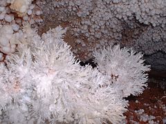
Boxwork was first noted in Wind Cave. These calcite fins were once cracks filling gypsum and anhydrite. Calcite-gypsum [[pseudomorph]]s are common. The released [[sulfuric acid]] weakened the bedrock, allowing it to weather faster than the calcite. The resultant intersecting fins form open chambers and protrude from the surrounding bedrock by amounts ranging from 0.6 to 1.2 m. Lower levels of the cave have boxworks mixed with frostwork and [[cave popcorn]]. [[Helictite]] bushes were also first discovered in Wind Cave. [[Moonmilk]] is found on many surfaces, while [[calcite rafts]] are found in the lower levels of the cave system.<ref name=KellerLynn/>{{rp|18,20–21}} |
|||
===In popular culture=== |
|||
During the [[2020 Democratic Party presidential primaries|2020 Democratic Party presidential primary]] [[2020 Democratic Party presidential debates#Sixth debate (December 19, 2019)|debate on December 19, 2019]], candidate Senator [[Amy Klobuchar 2020 presidential campaign|Amy Klobuchar]] referenced the Wind Cave as part of an attack on fellow candidate Mayor [[Pete Buttigieg 2020 presidential campaign|Pete Buttigieg]], who had hosted a campaign fundraiser in a purported wine cave. Klobuchar remarked, “I came here to make a case for progress, and I have never even been to a wine cave. I’ve been to the Wind Cave in South Dakota, which I suggest you go to.”<ref>{{Cite web|url=https://rapidcityjournal.com/news/local/govt-and-politics/presidential-candidate-promotes-wind-cave-during-debate/article_f8a64c30-dbc8-5f67-86ba-8e3855e03f8a.html|title = Presidential candidate promotes Wind Cave during debate}}</ref> South Dakota public figures, including the state's Representative [[Dusty Johnson]], used it to promote tourism to Wind Cave National Park.<ref>{{cite tweet|number=1207854211276238850|user=RepDustyJohnson|title=For once, I agree with @amyklobuchar....|date=20 December 2019}}</ref> |
|||
The cave is featured in Dan Jorgensen's novel ''And the Wind Whispered''. |
|||
==Gallery== |
|||
<gallery mode="packed" heights="120"> |
|||
File:Calcite boxwork, Wind Cave.jpg|Calcite [[boxwork]] removed from the cave; [[Field Museum of Natural History]], Chicago |
|||
File:Cave Frostwork and Popcorn-Wind Cave.JPG|[[Frostwork]] and [[Cave popcorn|popcorn]] formations |
|||
File:Prairie dog at Wind Cave National Park.jpg|A [[prairie dog]]; part of an extensive colony in the park |
|||
File:Flora in Wind Cave National Park.jpg|Flora of the prairie |
|||
File:Bison and Prairie Dog in Wind Cave National Park.jpg|Bison and prairie dogs are commonplace in the park. |
|||
</gallery> |
|||
==See also== |
==See also== |
||
{{div col|colwidth=33em}} |
|||
* [[Carlsbad Caverns National Park]] |
* [[Carlsbad Caverns National Park]] |
||
* [[Jewel Cave National Monument]] |
* [[Jewel Cave National Monument]] |
||
* [[Great Basin National Park]] (Lehman Caves) |
* [[Great Basin National Park]] (Lehman Caves) |
||
* [[Lava Beds National Monument]] (lava |
* [[Lava Beds National Monument]] (lava tubes) |
||
* [[Mammoth Cave National Park]] |
* [[Mammoth Cave National Park]] |
||
* [[Oregon Caves National Monument]] |
* [[Oregon Caves National Monument]] |
||
* [[Russell Cave National Monument]] |
* [[Russell Cave National Monument]] |
||
* [[Timpanogos Cave National Monument]] |
* [[Timpanogos Cave National Monument]] |
||
* [[List of longest caves in the United States]] |
|||
* [[List of longest caves]] |
|||
{{div col end}} |
|||
==References== |
==References== |
||
| Line 79: | Line 276: | ||
== External links == |
== External links == |
||
{{Sister project links|commons=Category:Wind Cave National Park|voy=Wind Cave National Park|wikt=no|b=no|n=no|q=no|s=no|v=no|species=no|d=no}} |
{{Sister project links|commons=Category:Wind Cave National Park|voy=Wind Cave National Park|wikt=no|b=no|n=no|q=no|s=no|v=no|species=no|d=no}} |
||
* |
*{{Official website}} of the [https://www.nps.gov/index.htm National Park Service] |
||
*[[Historic American Engineering Record]] documentation, all filed under Hot Springs, Fall River County, SD: |
|||
**{{HAER |survey=SD-53 |id=sd0080 |title=Beaver Creek Bridge |photos=5 |color=2 |dwgs=3 |data=9 |cap=1 |link=no}} |
|||
**{{HAER |survey=SD-54 |id=sd0081 |title=Pigtail Bridge |photos=6 |dwgs=3 |data=10 |cap=1 |link=no}} |
|||
**{{HAER |survey=SD-55 |id=sd0086 |title=Wind Cave Roads and Bridges |photos=51 |color=6 |dwgs=4 |data=66 |cap=5 |link=no}} |
|||
{{National parks of the United States}} |
{{National parks of the United States}} |
||
{{Black Hills, South Dakota}} |
{{Black Hills, South Dakota}} |
||
{{Protected areas of South Dakota}} |
{{Protected areas of South Dakota}} |
||
{{Subterranea}} |
|||
{{authority control}} |
|||
[[Category:Wind Cave National Park| ]] |
[[Category:Wind Cave National Park| ]] |
||
| Line 89: | Line 292: | ||
[[Category:Black Hills]] |
[[Category:Black Hills]] |
||
[[Category:Caves of South Dakota]] |
[[Category:Caves of South Dakota]] |
||
[[Category:Historic American Engineering Record in South Dakota]] |
|||
[[Category:Protected areas of Custer County, South Dakota]] |
[[Category:Protected areas of Custer County, South Dakota]] |
||
[[Category:Archaeological sites in South Dakota]] |
[[Category:Archaeological sites in South Dakota]] |
||
| Line 96: | Line 300: | ||
[[Category:Civilian Conservation Corps in South Dakota]] |
[[Category:Civilian Conservation Corps in South Dakota]] |
||
[[Category:Landforms of Custer County, South Dakota]] |
[[Category:Landforms of Custer County, South Dakota]] |
||
[[Category:Sacred natural sites]] |
|||
[[Category:Articles with WikiMiniAtlas displaying incorrectly; WMA not showing area]] |
|||
Revision as of 18:32, 9 May 2024
| Wind Cave National Park | |
|---|---|
 Boxwork formation | |
 Wind Cave Location in South Dakota  Wind Cave Location in the United States | |
| Location | Custer County, South Dakota, United States |
| Nearest city | Hot Springs, South Dakota |
| Coordinates | 43°33′23″N 103°28′43″W / 43.55635°N 103.47865°W |
| Area | 33,847 acres (136.97 km2)[1] |
| Established | January 9, 1903[2][3] |
| Visitors | 448,405 (in 2020)[4] |
| Governing body | National Park Service |
| Website | Wind Cave National Park |
 .jpg) |
| Southwestern South Dakota |
|---|
| Sculptures |
| Geologic and natural history |
| Mountains |
| Caves |
| Forests and wildernesses |
| Lakes |
| Scenic byways |
| Historic sites |
Wind Cave National Park is an American national park located 10 miles (16 km) north of the town of Hot Springs in western South Dakota. Established on January 3, 1903[3] by President Theodore Roosevelt, it was the sixth national park in the U.S. and the first cave to be designated a national park anywhere in the world. The cave is notable for its calcite formations known as boxwork, as well as its frostwork.[5] Approximately 95 percent of the world's discovered boxwork formations are found in Wind Cave.
Wind Cave is one of the best known examples of a breathing cave. The cave is recognized as the densest cave system in the world, with the greatest passage volume per cubic mile. Wind Cave is the seventh longest cave in the world with 154.2 miles (248.16 km) of explored cave passageways (as of 2021[update]) and the third longest cave in the United States, though it is only the second longest cave in Custer County, South Dakota behind Jewel Cave.[6] Despite the close proximity, no connection has ever been found between Wind Cave and Jewel Cave and most geologists believe the caves are not connected.[7] Above ground, the park includes the largest remaining natural mixed grass prairie in the United States.
Origin of name
The passages of the cave are said to "breathe" as air continually moves into or out of them, equalizing the atmospheric pressure of the cave and the outside air. When the air pressure is higher outside the cave than inside it, air flows into the cave, raising the cave's pressure to match the outside pressure. When the air pressure inside the cave is higher than outside it, air flows out of the cave, lowering the air pressure within the cave.[8] A large cave such as Wind Cave with only a few small openings will "breathe" more obviously than a small cave with many large openings.
Rapid weather changes, accompanied by rapid barometric changes, are a feature of western South Dakota weather. If a fast-moving storm was approaching on the day the Bingham brothers found the cave, the atmospheric pressure would have been dropping fast, causing the cave's higher-pressure air to rush out all available openings, creating the wind for which Wind Cave was named.
History
The Lakota, Cheyenne, and other Native American tribes who traveled through and made camps around the area were aware of the cave's existence, as were early Euro-American settlers, but there has been no recorded evidence discovered that anyone actually entered it.[9]
The Lakota (Sioux), an indigenous people who live in the Black Hills region of South Dakota, spoke of a hole that blew air, a place they consider sacred as the site where they first emerged from the underworld where they had lived before the demiurge creation of the world.[9] Originally called Washun Niya, Wind Cave played an important role in the traditions and culture of the Lakota people.[10] The fables of these people tell the story of Tokahe, the first human to emerge from the cave, symbolizing an emergence from the underworld. His story and presence at Wind Cave is an important part of Lakota history, and heavily influences their origin story.
Wind Cave and other areas throughout the Black Hills were important to the native people in other ways beyond spirituality. Nicknamed, euphemistically, as a “supermarket,” the areas surrounding the cave provided abundant resources for native survival. Often during the winter seasons, such areas served as ideal spots for camps; much of the game they hunted preferred the shelter provided by the cave and made these areas ideal to become Lakota settlements and hunting grounds.[11]
The eventual dispossession of the Lakota people followed the consistent history of dispossession of indigenous peoples across the country. In 1851 a Treaty was formed at Fort Laramie, entering the tribe into a legal relationship with the U.S. government.[12] Another Treaty of Fort Laramie in 1868 redefined and reduced the borders of Lakota land within the Black Hills.[12] Article two within that treaty allowed for forts to be built within Lakota land and in 1874 General George A. Custer began surveying the land and mistakenly reported a significant presence of gold, despite the geologist on his team of surveyors saying there were no quantities of substance.[12] Miners then began to invade the hills in search of gold, which was against the treaty with the Lakota people, though the government did little to punish such offenses. In 1875 the Lakota title to the land was deemed invalid due to their lack of structural development and supposed “wasting” of the land.[12] When the Dawes Act was passed in 1877, the site was opened to settlers and effectively sealed the dispossession of the Lakota from their ancestral lands.[12]
The first documented discovery of the cave by white Americans was in 1881, when the brothers Tom and Jesse Bingham heard wind rushing out from a 10-inch (25 cm) by 14-inch (36 cm) hole in the ground. According to the story, when Tom looked into the hole, the wind exiting the cave blew his hat off of his head.[8]
From 1881 to 1889, few people ventured far into Wind Cave. Then in 1889 the South Dakota Mining Company hired Jesse D. McDonald to oversee their mining claim on the cave site. The South Dakota Mining Company may have hoped to find valuable minerals, or it may have had commercial development of the cave in mind from the start.[13]
No valuable mineral deposits were found, and the McDonald family began developing the cave for tourism. Jesse initially hired his son Alvin (age 16 in 1890) and, beginning in 1891, Alvin's brother Elmer, to explore and help develop the cave.[14] Alvin fell in love with the cave and kept a cave diary.[15] Others who worked at Wind Cave and helped explore it between 1890 and 1903 include Katie Stabler, Emma McDonald (Elmer's wife), Inez McDonald (Emma and Elmer's daughter), and Tommy McDonald (brother of Elmer and Alvin).[9]
By February 1892 the cave was open for visitors;[16] the standard tour fee was apparently $1.00[17] (equivalent to roughly $30 in 2021). Tourists explored the cave by candlelight on guided tours. These early tours were physically demanding and sometimes involved crawling through narrow passages.
Like the nearby Jewel Cave National Monument, currently the third longest cave in the world, Herb and Jan Conn played an important role in cave exploration during the 1960s.[18]
Flora and fauna

Wind Cave National Park protects a diverse ecosystem with eastern and western plant and animal species. Wildlife that inhabits this park include raccoons, elk, bison, coyotes, skunks, badgers, ermines, black-footed ferrets, cougars, bobcats, red foxes, minks, whooping crane, pronghorn and prairie dogs. The Wind Cave bison herd is one of only four free-roaming and genetically pure herds on public lands in North America. The other three herds are the Yellowstone Park bison herd, the Henry Mountains bison herd in Utah, and on Elk Island in Alberta, Canada. The Wind Cave bison herd is currently brucellosis-free.[8]
Endangered species
-
 Whooping Crane
 -
 Black-footed ferret


The black-footed ferret and whooping crane are on the endangered species list.[19][20] The whooping crane population in Wind Cave National Park is considered a non-self-sustaining wild population.[20]
Climate
| Climate data for Wind Cave, South Dakota (1991–2020 normals, extremes 1990–present) | |||||||||||||
|---|---|---|---|---|---|---|---|---|---|---|---|---|---|
| Month | Jan | Feb | Mar | Apr | May | Jun | Jul | Aug | Sep | Oct | Nov | Dec | Year |
| Record high °F (°C) | 69 (21) |
69 (21) |
77 (25) |
89 (32) |
92 (33) |
102 (39) |
105 (41) |
101 (38) |
103 (39) |
89 (32) |
76 (24) |
66 (19) |
105 (41) |
| Mean maximum °F (°C) | 57.5 (14.2) |
57.7 (14.3) |
69.3 (20.7) |
77.3 (25.2) |
84.6 (29.2) |
91.8 (33.2) |
96.0 (35.6) |
94.7 (34.8) |
91.3 (32.9) |
79.7 (26.5) |
67.2 (19.6) |
56.9 (13.8) |
97.7 (36.5) |
| Mean daily maximum °F (°C) | 39.7 (4.3) |
40.7 (4.8) |
50.0 (10.0) |
57.7 (14.3) |
66.4 (19.1) |
77.4 (25.2) |
84.7 (29.3) |
83.6 (28.7) |
76.2 (24.6) |
61.4 (16.3) |
48.4 (9.1) |
39.4 (4.1) |
60.5 (15.8) |
| Daily mean °F (°C) | 27.2 (−2.7) |
28.1 (−2.2) |
36.8 (2.7) |
44.3 (6.8) |
53.7 (12.1) |
63.8 (17.7) |
70.7 (21.5) |
69.2 (20.7) |
61.2 (16.2) |
47.7 (8.7) |
35.9 (2.2) |
27.4 (−2.6) |
47.2 (8.4) |
| Mean daily minimum °F (°C) | 14.8 (−9.6) |
15.5 (−9.2) |
23.7 (−4.6) |
30.9 (−0.6) |
40.9 (4.9) |
50.1 (10.1) |
56.6 (13.7) |
54.9 (12.7) |
46.2 (7.9) |
34.0 (1.1) |
23.4 (−4.8) |
15.4 (−9.2) |
33.9 (1.1) |
| Mean minimum °F (°C) | −9.6 (−23.1) |
−8.3 (−22.4) |
1.2 (−17.1) |
14.6 (−9.7) |
26.0 (−3.3) |
37.6 (3.1) |
45.8 (7.7) |
42.8 (6.0) |
31.5 (−0.3) |
15.1 (−9.4) |
1.5 (−16.9) |
−7.2 (−21.8) |
−18.2 (−27.9) |
| Record low °F (°C) | −30 (−34) |
−32 (−36) |
−20 (−29) |
1 (−17) |
15 (−9) |
30 (−1) |
38 (3) |
31 (−1) |
23 (−5) |
−2 (−19) |
−15 (−26) |
−27 (−33) |
−32 (−36) |
| Average precipitation inches (mm) | 0.45 (11) |
0.70 (18) |
1.07 (27) |
2.32 (59) |
3.74 (95) |
3.29 (84) |
3.01 (76) |
2.30 (58) |
1.53 (39) |
1.55 (39) |
0.71 (18) |
0.53 (13) |
21.20 (538) |
| Average snowfall inches (cm) | 6.3 (16) |
7.1 (18) |
9.6 (24) |
7.8 (20) |
0.9 (2.3) |
0.0 (0.0) |
0.0 (0.0) |
0.0 (0.0) |
0.2 (0.51) |
2.1 (5.3) |
4.4 (11) |
7.5 (19) |
45.9 (117) |
| Average precipitation days (≥ 0.01 in) | 4.5 | 5.8 | 6.0 | 9.4 | 11.2 | 11.4 | 9.7 | 8.5 | 6.3 | 7.0 | 4.1 | 3.8 | 87.7 |
| Average snowy days (≥ 0.1 in) | 3.9 | 4.9 | 3.5 | 2.8 | 0.5 | 0.0 | 0.0 | 0.0 | 0.1 | 1.1 | 2.7 | 3.6 | 23.1 |
| Source: NOAA[21][22] | |||||||||||||
Throughout the years, the great plains have seen a considerable rise in temperature. Being that Wind Cave is located in the great plains, these temperature rises have already started to affect the park and the area around it.[23] The average temperature rise across the plains has been two degrees Fahrenheit, with some areas seeing increases as high as five degrees Fahrenheit.[23] This trend is projected to cause drought like conditions in the area.[23]
Infrastructure
Several roads run through the park and there are 30 miles (48 km) of hiking trails on the surface. The park had an estimated 656,397 visitors in 2018.[4] More than 109,000 people toured the cave itself in 2015, the most since 1968 before cave tours were limited to 40 people each.[24]
The Wind Cave visitor center features three exhibit rooms about the geology of the caves and early cave history, the park's wildlife and natural history, and the work of the Civilian Conservation Corps in the park.
Elk Mountain Campground, located in a ponderosa pine forest, is about 1.25 miles (2.0 km) from the visitor center. The campground has 75 sites for tents and recreational vehicles and is open year-round with campfire programs offered in the summer and limited services available in the winter.[8]
Geology

NPS Wind Cave National Park Geologic Map, where Mp is the Mississippian Pahasapa (Madison) Limestone, Phm is the Pennsylvanian Minnelusa Formation, Po is the Permian Opeche Shale, Pm is the Minnekahta Limestone, TRPs is the Triassic Spearfish Formation, Tw is the Tertiary White River Group, while Qal and Qt are Quaternary alluvial deposits
The three levels making up the Wind Cave system are located in the upper 76 m of the Mississippian Pahasapa Limestone. Deposited in an inland sea, chert, gypsum, and anhydrite lenses within the limestone are evidence of high periods of evaporation. When sea levels dropped at the end of the Mississippian, dissolution of the limestone formed a Kaskaskia paleokarst terrain, complete with solution fissures, sinkholes, and caves. Thus, an unconformity exists between this limestone and the overlying Pennsylvanian Minnelusa Formation. These red sands and clays filled in cavities. Those cavities not filled in were coated in dogtooth spar. Subsequent deposition of the Permian Opeche Shale, Permian Minnekahta Limestone, Triassic Spearfish Formation, and Tertiary White River Group followed. Paleocene and Eocene erosion removed these overlying sediments, in the area of the caves, down to the Minnelusa. Geologic uplift started during the Laramide Orogeny, which lowered the water table, draining the cave system and enlarging it. Today the water level is 150 m below the surface, which amounts to a drop of 0.4 m every 1000 years.[25]
Boxwork was first noted in Wind Cave. These calcite fins were once cracks filling gypsum and anhydrite. Calcite-gypsum pseudomorphs are common. The released sulfuric acid weakened the bedrock, allowing it to weather faster than the calcite. The resultant intersecting fins form open chambers and protrude from the surrounding bedrock by amounts ranging from 0.6 to 1.2 m. Lower levels of the cave have boxworks mixed with frostwork and cave popcorn. Helictite bushes were also first discovered in Wind Cave. Moonmilk is found on many surfaces, while calcite rafts are found in the lower levels of the cave system.[25]: 18, 20–21
In popular culture
During the 2020 Democratic Party presidential primary debate on December 19, 2019, candidate Senator Amy Klobuchar referenced the Wind Cave as part of an attack on fellow candidate Mayor Pete Buttigieg, who had hosted a campaign fundraiser in a purported wine cave. Klobuchar remarked, “I came here to make a case for progress, and I have never even been to a wine cave. I’ve been to the Wind Cave in South Dakota, which I suggest you go to.”[26] South Dakota public figures, including the state's Representative Dusty Johnson, used it to promote tourism to Wind Cave National Park.[27]
The cave is featured in Dan Jorgensen's novel And the Wind Whispered.
Gallery
-
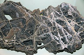 Calcite boxwork removed from the cave; Field Museum of Natural History, Chicago
 -
-
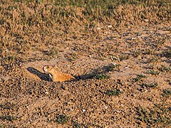 A prairie dog; part of an extensive colony in the park
 -
 Flora of the prairie
 -
 Bison and prairie dogs are commonplace in the park.


See also
- Carlsbad Caverns National Park
- Jewel Cave National Monument
- Great Basin National Park (Lehman Caves)
- Lava Beds National Monument (lava tubes)
- Mammoth Cave National Park
- Oregon Caves National Monument
- Russell Cave National Monument
- Timpanogos Cave National Monument
- List of longest caves in the United States
- List of longest caves
References
- ^ "Listing of acreage – December 31, 2011" (XLSX). Land Resource Division, National Park Service. Retrieved March 7, 2012. (National Park Service Acreage Reports)
- ^ "Park Celebrates Centennial - Wind Cave National Park (U.S. National Park Service)".
- ^ a b "Birth of a National Park - A National Park is Created". Wind Cave National Park. National Park Service. Retrieved 15 May 2022.
- ^ a b "NPS Annual Recreation Visits Report". National Park Service. Retrieved August 11, 2021.
- ^ "Wind Cave National Park (U.S. National Park Service)". www.nps.gov. Retrieved 2022-02-26.
- ^ Gulden, Bob (April 19, 2021). "Worlds longest caves". Geo2 Committee on Long and Deep Caves. National Speleological Society (NSS). Retrieved September 4, 2021.
- ^ "Esri News -- ArcNews Winter 2002/2003 Issue -- Developing a Cave Potential Map for South Dakota's Wind Cave Using GIS". www.esri.com. Retrieved 2024-01-08.
- ^ a b c d Wind Cave brochure, National Park Service, GPO, WDC
- ^ a b c National Park Service: Early cave explorers
- ^ Fritz, Jessica Garcia, and Federico Garcia Lammers. "ORIGINS FROM WIND CAVE WASHUN NIYA: SACRED SPACE AS CONTESTED TERRITORY." GENIUS LOCI: 33.
- ^ Albers, Patricia; Berndt, Christina; Brown, Elizabeth; Kelly, Yvonne; Kittelson, Vanessa; Rossina, Kim; Schlegel, Stacy; Yardley, Andrea (2003-01-01). "The Home of the Bison : An Ethnographic and Ethnohistorical Study of Traditional Cultural Affiliations to Wind Cave National Park". U.S. National Park Service Publications and Papers.
- ^ a b c d e Eagle, Bear (2018). Oníya Ošóka: The Interpretation of Oglála Lakȟóta Continuing and Historical Relational Connections at Wind Cave National Park (Thesis). UCLA.
- ^ "Wind Cave National Park - Alvin McDonald (1873-1893) (U.S. National Park Service)". Archived from the original on 2007-02-16.
- ^ McDonald, Alvin Frank. A Private Account of A. F. McDonald, Permanent Guide of Wind Cave (a.k.a. "Alvin McDonald Diary," written 1891–1893). Facsimile ed., no pub. data. Sold through Wind Cave National Park. Financial entries, pp. 20-21 and 23-25.
- ^ "Alvin McDonald's Diary - Wind Cave National Park (U.S. National Park Service)".
- ^ McDonald, Alvin Frank. A Private Account of A. F. McDonald, Permanent Guide of Wind Cave (a.k.a. "Alvin McDonald Diary," written 1891–1893). Facsimile ed., no pub. data. Sold through Wind Cave National Park. Financial entries, p. 9
- ^ McDonald, Alvin Frank. A Private Account of A. F. McDonald, Permanent Guide of Wind Cave (a.k.a. "Alvin McDonald Diary," written 1891–1893). Facsimile ed., no pub. data. Sold through Wind Cave National Park. Financial entries, p. 8-9
- ^ Higbee, paul (January 1998). "Explorers of an Unseen World". South Dakota Magazine. Retrieved 2 November 2021.
- ^ "Map of threatened and endangered species in National Parks". Wildlife and Wild Lands. Retrieved 2022-04-18.
- ^ a b "ECOS: Species Profile". ecos.fws.gov. Retrieved 2022-04-18.
- ^ "NOWData – NOAA Online Weather Data". National Oceanic and Atmospheric Administration. Retrieved June 12, 2021.
- ^ "Summary of Monthly Normals 1991–2020". National Oceanic and Atmospheric Administration. Retrieved June 12, 2021.
- ^ a b c "Climate Change - Wind Cave National Park (U.S. National Park Service)". www.nps.gov. Retrieved 2022-02-26.
- ^ Kent, Jim (January 19, 2016). "Wind Cave Numbers Highest In 40 Years". South Dakota Public Broadcasting. Retrieved January 19, 2016.
- ^ a b KellerLynn, K. (2009). Wind Cave National Park Geologic Resources Inventory Report, Natural Resource Report NPS/NRPC/GRD/NRR-2009/087. Denver: National Park Service. pp. 14–15, 29–30.
- ^ "Presidential candidate promotes Wind Cave during debate".
- ^ @RepDustyJohnson (December 20, 2019). "For once, I agree with @amyklobuchar..." (Tweet) – via Twitter.
External links
 Media from Commons
 Travel information from Wikivoyage
- Official website
 of the National Park Service
 - Historic American Engineering Record documentation, all filed under Hot Springs, Fall River County, SD:
- HAER No. SD-53, "Beaver Creek Bridge", 5 photos, 2 color transparencies, 3 measured drawings, 9 data pages, 1 photo caption page
- HAER No. SD-54, "Pigtail Bridge", 6 photos, 3 measured drawings, 10 data pages, 1 photo caption page
- HAER No. SD-55, "Wind Cave Roads and Bridges", 51 photos, 6 color transparencies, 4 measured drawings, 66 data pages, 5 photo caption pages
| International | |
|---|---|
| National | |
| Other | |
- IUCN Category II
- Wind Cave National Park
- National parks in South Dakota
- Black Hills
- Caves of South Dakota
- Historic American Engineering Record in South Dakota
- Protected areas of Custer County, South Dakota
- Archaeological sites in South Dakota
- Blowholes
- 1903 establishments in South Dakota
- Protected areas established in 1903
- Civilian Conservation Corps in South Dakota
- Landforms of Custer County, South Dakota
- Sacred natural sites