
Ocna Mureș: Difference between revisions
one more pic |
No edit summary Tags: Mobile edit Mobile web edit |
||
| Line 27: | Line 27: | ||
The town administers five villages: Cisteiu de Mureș (''Magyarcsesztve''), Micoșlaca (''Miklóslaka''), Războieni-Cetate (''Székelyföldvár''), Uioara de Jos (until 1960 ''Ciunga''; ''Csongva''), and Uioara de Sus (''Felsőmarosújvár''). Its former name is ''Uioara'', and was called ''Ocna Mureșului'' from 1925 to 1956. |
The town administers five villages: Cisteiu de Mureș (''Magyarcsesztve''), Micoșlaca (''Miklóslaka''), Războieni-Cetate (''Székelyföldvár''), Uioara de Jos (until 1960 ''Ciunga''; ''Csongva''), and Uioara de Sus (''Felsőmarosújvár''). Its former name is ''Uioara'', and was called ''Ocna Mureșului'' from 1925 to 1956. |
||
The spa is again open to public, do to new investments made by the city and county in a new building with spa, salty basins, medical treatments and sports facilities. |
|||
| ⚫ | |||
The chemical plant in town was lastly purchased by an Indian company from a company based in Timișoara. Currently, the plant has ceased activity and the old buildings were demolished to make room for new enterprises.The majority of high school students attend either Liceul Teoretic Petru Maior or the 'Industrial Highschool,' where many are trained to later work in mechanics, electrical and IT. |
|||
| ⚫ | Exceptional students progress onto university studies, generally in nearby [[Cluj-Napoca]] or [[Alba Iulia]], the county capital. The town’s salt mine the was flooded in 1977 and the ground became unstable and collapsed .Now this area is filled with more than 4 large, salty and very deep ponds. The center of the town and city hall are located at the base of a large hill, the 'Banța.' |
||
== Demographics == |
== Demographics == |
||
Revision as of 22:58, 8 November 2023
Ocna Mureș | |
|---|---|
 | |
 Coat of arms | |
 Location in Alba County | |
 Ocna Mureș Location in Romania | |
| Coordinates: 46°23′24″N 23°51′36″E / 46.39000°N 23.86000°E | |
| Country | Romania |
| County | Alba |
| Government | |
| • Mayor (2020–2024) | Silviu Vințeler[1] (PNL) |
| Area | 68.34 km2 (26.39 sq mi) |
| Elevation | 208 m (682 ft) |
| Population (2021-12-01)[2] | 12,480 |
| • Density | 180/km2 (470/sq mi) |
| Time zone | EET/EEST (UTC+2/+3) |
| Postal code | 515700 |
| Area code | (+40) 02 58 |
| Vehicle reg. | AB |
| Website | www |
Ocna Mureș (Romanian pronunciation: [ˌokna ˈmureʃ]; Latin: Salinae, Hungarian: Marosújvár, German: Miereschhall) is a town in Alba County, Romania, located in the north-eastern corner of the county, near the Mureș River. The town is situated next to a large deposit of salt, mined in the past until the ceiling of the mines collapsed from water infiltration in 1978. Ocna Mureș has a chlorosodic products plant, a salt extraction plant and a spa which uses the salty water from the former mines.
The town administers five villages: Cisteiu de Mureș (Magyarcsesztve), Micoșlaca (Miklóslaka), Războieni-Cetate (Székelyföldvár), Uioara de Jos (until 1960 Ciunga; Csongva), and Uioara de Sus (Felsőmarosújvár). Its former name is Uioara, and was called Ocna Mureșului from 1925 to 1956.
The spa is again open to public, do to new investments made by the city and county in a new building with spa, salty basins, medical treatments and sports facilities. The chemical plant in town was lastly purchased by an Indian company from a company based in Timișoara. Currently, the plant has ceased activity and the old buildings were demolished to make room for new enterprises.The majority of high school students attend either Liceul Teoretic Petru Maior or the 'Industrial Highschool,' where many are trained to later work in mechanics, electrical and IT. Exceptional students progress onto university studies, generally in nearby Cluj-Napoca or Alba Iulia, the county capital. The town’s salt mine the was flooded in 1977 and the ground became unstable and collapsed .Now this area is filled with more than 4 large, salty and very deep ponds. The center of the town and city hall are located at the base of a large hill, the 'Banța.'
Demographics
| Year | Pop. | ±% |
|---|---|---|
| 1956 | 10,701 | — |
| 1966 | 12,126 | +13.3% |
| 1977 | 16,416 | +35.4% |
| 1992 | 16,256 | −1.0% |
| 2002 | 15,697 | −3.4% |
| 2011 | 13,036 | −17.0% |
| 2021 | 12,480 | −4.3% |
| Source: Census data | ||
At the 2021 census, Ocna Mureș had a population of 12,480. According to the census from 2011, the town had a total population of 13,036; of those, 83.46% were ethnic Romanians, 9.31% ethnic Hungarians, and 7% ethnic Romani.[3]
Natives
- Ovidiu Maier (born 1971), professional footballer
- Rareș Bogdan (born 1974), journalist and politician
Climate
Ocna Mureș has a humid continental climate (Cfb in the Köppen climate classification).
| Climate data for Ocna Mureș | |||||||||||||
|---|---|---|---|---|---|---|---|---|---|---|---|---|---|
| Month | Jan | Feb | Mar | Apr | May | Jun | Jul | Aug | Sep | Oct | Nov | Dec | Year |
| Mean daily maximum °C (°F) | 1.8 (35.2) |
4.8 (40.6) |
10.4 (50.7) |
16.4 (61.5) |
21 (70) |
24.3 (75.7) |
26.2 (79.2) |
26.4 (79.5) |
21.3 (70.3) |
15.5 (59.9) |
9.4 (48.9) |
3.2 (37.8) |
15.1 (59.1) |
| Daily mean °C (°F) | −2 (28) |
0.2 (32.4) |
5 (41) |
10.9 (51.6) |
15.9 (60.6) |
19.5 (67.1) |
21.3 (70.3) |
21.3 (70.3) |
16.3 (61.3) |
10.5 (50.9) |
5 (41) |
−0.4 (31.3) |
10.3 (50.5) |
| Mean daily minimum °C (°F) | −5.4 (22.3) |
−3.7 (25.3) |
−0.2 (31.6) |
5.2 (41.4) |
10.3 (50.5) |
14 (57) |
15.9 (60.6) |
16.2 (61.2) |
11.6 (52.9) |
6.1 (43.0) |
1.5 (34.7) |
−3.3 (26.1) |
5.7 (42.2) |
| Average precipitation mm (inches) | 35 (1.4) |
33 (1.3) |
47 (1.9) |
70 (2.8) |
94 (3.7) |
112 (4.4) |
108 (4.3) |
94 (3.7) |
73 (2.9) |
55 (2.2) |
41 (1.6) |
43 (1.7) |
805 (31.9) |
| Source: https://en.climate-data.org/europe/romania/alba/ocna-mures-15288/ | |||||||||||||
See also
References
- ^ "Results of the 2020 local elections". Central Electoral Bureau. Retrieved 6 June 2021.
- ^ "Populaţia rezidentă după grupa de vârstă, pe județe și municipii, orașe, comune, la 1 decembrie 2021" (XLS). National Institute of Statistics.
- ^ "Structura Etno-demografică a României". Edrc.ro. Retrieved 8 October 2017.
-
 Town hall
 -
 Salt lake and well field (1991)
 -
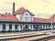 Războieni-Cetate train station
 -
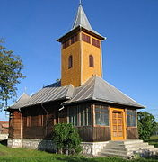 Wooden church in Cisteiu de Mureș
.jpg)


| International | |
|---|---|
| National | |
This Alba County location article is a stub. You can help Wikipedia by expanding it. |