
Hoparta
|
Hopârta Meerport Háporton |
|||||
|
|||||
| Basic data | |||||
|---|---|---|---|---|---|
| State : |
|
||||
| Historical region : | Transylvania | ||||
| Circle : | Alba | ||||
| Coordinates : | 46 ° 19 ' N , 23 ° 52' E | ||||
| Time zone : | EET ( UTC +2) | ||||
| Height : | 355 m | ||||
| Area : | 61.48 km² | ||||
| Residents : | 1,152 (2011) | ||||
| Population density : | 19 inhabitants per km² | ||||
| Postal code : | 517335 | ||||
| Telephone code : | (+40) 02 58 | ||||
| License plate : | FROM | ||||
| Structure and administration (as of 2016) | |||||
| Community type : | local community | ||||
| Structure : | Hopârta, Silivaș , Șpălnaca , Turdaș , Vama Seacă | ||||
| Mayor : | Augustin Popa ( PNL ) | ||||
| Postal address : | Str. Principală, no. 159 loc. Hoparta, jud. Alba, RO-517335 |
||||
| Website : | |||||


Hopârta or, old spelling, Hopîrta [ ˈhopɨrta ] (outdated Hăpîrta ; German Meerport , Hungarian Háporton ) is a Romanian municipality in the Alba district in Transylvania .
location

The place Hopârta is located in the northeast of the district of Alba, on the river Hopârta of the same name - a tributary of the Mureș - and the county road (Drum județean) DJ 107E. With the four incorporated villages, which are 2 to 6 kilometers away from the village of Hopârta, the municipality extends over an area of 6148 hectares in the west of the Transylvanian Basin . It is 16 kilometers to the next larger town of Aiud (Strasbourg am Mieresch) ; the district capital Alba Iulia (Karlsburg) is about 43 kilometers southwest. Hopârta is located 9.5 kilometers (as the crow flies) east (left) of the river Mureș (Mieresch) .
history
Various archaeological finds - beginning from the Neolithic Age - show that the area was inhabited for a long time; other finds come from the Roman period. The place was first mentioned in 1332, when the priest of the place delivered the first part of the papal tithe for the current year, under the name sacerdos de Hupurtun . In 1854 the later official Hungarian name Háporton is attested.
In the Middle Ages the place was owned by the Weißenburg cathedral chapter, later a free Saxon chair community.
population
The population of the municipality developed as follows:
| census | Ethnic composition | |||||||
|---|---|---|---|---|---|---|---|---|
| year | population | Romanians | Hungary | German | other | |||
| 1850 | 2,541 | 2,447 | 42 | - | 52 | |||
| 1900 | 3,205 | 2,953 | 184 | 11 | 57 | |||
| 1956 | 3,564 | 3,480 | 42 | 1 | 41 | |||
| 1992 | 1,558 | 1,471 | 14th | - | 73 | |||
| 2002 | 1,372 | 1,212 | 8th | 1 | 151 | |||
The number of inhabitants in the area of today's municipality has decreased significantly since its peak in 1956. The highest population of the German population (21, including 16 in Hopârta itself) was registered in 1880, the Hungarians 1900 and the Roma in 2002. The village of Vama Seacă (Hungarian Szárazvámtanya ) has only been recorded as an independent administrative unit since 1956.
Attractions
- The Romanian Orthodox Church Sf. Gheorghe
- In the incorporated village of Șpălnaca ( Buchhof ), the wooden churches Sf. Arhangheli (construction started in the 18th / and finished in the 20th century) and Sf. Gheorghe (built in the 18th century, renovated in 1865) are a listed building.
- The wooden church Sfinții Arhangheli Mihail și Gavriil in the incorporated village of Turdaș ( Thorendorf ), built in 1770 and expanded in 1826, is a listed building.

The wooden church Sf. Gheorghe in the village of Șpălnaca

The wooden church Sf. Gheorghe in the village of Șpălnaca

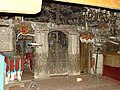
Altar of the wooden church Sf. Gheorghe in the village of Șpălnaca

The wooden church Sfinții Arhangheli Mihail și Gavriil in the village of Turdaș

The wooden church Sf. Arhangheli Mihail și Gavriil from Turdaș
Altar of the wooden church Sf. Arhangheli Mihail și Gavriil from Turdaș


Web links
Individual evidence
- ↑ Mayoral elections 2016 in Romania ( MS Excel ; 256 kB)
- ^ Dictionary of the localities in Transylvania
- ↑ Heinz Heltmann, Gustav Servatius (Ed.): Travel Guide Siebenbürgen. Kraft-Verlag, Würzburg 1993, ISBN 3-8083-2019-2 .
- ^ Institute Of Archeology - Hopârta, accessed February 15, 2010 (Romanian)
- ↑ a b History of Hopârta on www.primariahopirta.ro, accessed February 16, 2010
- ↑ Hopârta ( Memento of April 13, 2010 in the Internet Archive )
- ↑ Census, last updated October 30, 2008, p. 92 (Hungarian; PDF; 1.2 MB)
- ↑ a b List of historical monuments of the Romanian Ministry of Culture, updated 2010 (PDF; 7.10 MB)
Albac | Almașu Mare | Arieșeni | Avram Iancu | Berghin | Bistra | Blandiana | Bucerdea Grânoasă | Bucium | Câlnic | Cenade | Cergău | Ceru-Băcăinți | Cetatea de Baltă | Ciugud | Ciuruleasa | Crăciunelu de Jos | Cricău | Cut | Daia Română | Doștat | Fărău | Galda de Jos | Gârbova | Gârda de Sus | Hopârta | Horea | Ighiu | Întregalde | Jidvei | Livezile | Lopadea Nouă | Lunca Mureșului | Lupșa | Meteș | Mihalț | Mirăslău | Mogoș | Noșlac | Ocoliș | Ohaba | Pianu | Poiana Vadului | Ponor | Poșaga | Rădeşti | Râmeț | Rimetea | Roșia de Secaș | Roșia Montană | Sălciua | Săliştea | Sâncel | Sântimbru | Săsciori | Scărișoara | Șibot | Sohodol | Șona | Șpring | Stremț | Șugag | Unirea | Vadu Moților | Valea Lunga | Vidra | Vințu de Jos