Sâncel (Alba)
|
Sâncel Simtschal Szancsal |
||||
|
||||
| Basic data | ||||
|---|---|---|---|---|
| State : |
|
|||
| Historical region : | Transylvania | |||
| Circle : | Alba | |||
| Coordinates : | 46 ° 12 ' N , 23 ° 57' E | |||
| Time zone : | EET ( UTC +2) | |||
| Height : | 251 m | |||
| Area : | 50.94 km² | |||
| Residents : | 2,411 (October 20, 2011) | |||
| Population density : | 47 inhabitants per km² | |||
| Postal code : | 517670 | |||
| Telephone code : | (+40) 02 58 | |||
| License plate : | FROM | |||
| Structure and administration (as of 2016) | ||||
| Community type : | local community | |||
| Structure : | Sâncel, Iclod , Pănade | |||
| Mayor : | Ilie Frățilă ( PNL ) | |||
| Postal address : | Mihai Eminescu Street, no. 70 loc. Sâncel, jud.Alba, RO-517670 |
|||
| Website : | ||||
| Others | ||||
| City Festival : | April 23, the Burduhoasa festival | |||
Sâncel or Sîncel ( German Simtschal , Hungarian Szancsal ) is a Romanian municipality in the Alba district in Transylvania .
The place Sâncel is also known under the Hungarian names Oláhszancsal and Böszörményszancsal .
Geographical location
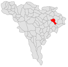
The municipality of Sâncel is located in the southwest of the Transylvanian Basin , on the Târnava Mică (Little Kokel) . Sâncel is located about 3 kilometers north of Blaj (Bubble Village) on the Blaj – Praid railway line and the DJ 107 district road (Drum județean ) ; the district capital Alba Iulia (Karlsburg) is about 43 kilometers southwest of Sâncel.
history
The place Sâncel was first mentioned in a document in 1252 (according to various sources) under the name Terra Zonchel , or in 1300. In 1347 the name Sâmcel is attested. After 1461 the place was a Romanian serf village with Romanian and Hungarian population and belonged to the domain Langenthal in the county of Klein-Kokelburg . The place has been known as Sâncel since 1854 .
population
The population of the municipality developed as follows:
| census | Ethnic composition | |||||||
|---|---|---|---|---|---|---|---|---|
| year | population | Romanians | Hungary | German | other | |||
| 1850 | 2,778 | 2,557 | 59 | - | 126 | |||
| 1910 | 3,296 | 3,101 | 98 | 24 | 73 | |||
| 1956 | 3,924 | 3,878 | 21st | 1 | 24 | |||
| 2002 | 2,790 | 2,532 | 13 | 1 | 244 | |||
| 2011 | 2.411 | 2,179 | 7th | - | 225 | |||
The highest population of today's municipality - and at the same time that of the Romanians - was determined in 1956. The highest population of Germans (29) was registered in 1880, Hungarians (170) in 1900 and Roma (243) in 2002.
Attractions
- The Romanian Orthodox Church Sfântului Mare Mucenic Dimitrie , built 1970–1975.
- The Romanian Uniate Church
- The bust of Timotei Cipariu
Twin cities
Sâncel has partnerships with the towns of Nuelles and Saint-Germain-sur-l'Arbresle in the canton of L'Arbresle in France
Personalities
- Timotei Cipariu (1805-1887), born in the incorporated village of Pănade ( Panagen ), was a Romanian philologist , journalist and professor of philosophy and theology .
Web links
Individual evidence
- ↑ 2011 census in Romania ( MS Excel ; 1.3 MB)
- ↑ Mayoral elections 2016 in Romania ( MS Excel ; 256 kB)
- ↑ Picture and description of the Burduhoasa festival (Romanian)
- ^ Dictionary of the localities in Transylvania
- ^ Sâncel ( Memento of April 13, 2010 in the Internet Archive )
- ↑ Heinz Heltmann, Gustav Servatius (Ed.): Travel Guide Siebenbürgen. Kraft-Verlag, Würzburg 1993, ISBN 3-8083-2019-2
- ↑ Census, last updated October 30, 2008, p. 157 (Hungarian; PDF; 1.2 MB)
- ^ Website of the municipality of Sâncel, accessed on May 25, 2010


