
Lunca Mureșului (Alba)
|
Lunca Mureșului Székelykocsárd |
|||||
|
|||||
| Basic data | |||||
|---|---|---|---|---|---|
| State : |
|
||||
| Historical region : | Transylvania | ||||
| Circle : | Alba | ||||
| Coordinates : | 46 ° 26 ' N , 23 ° 54' E | ||||
| Time zone : | EET ( UTC +2) | ||||
| Height : | 291 m | ||||
| Area : | 31.21 km² | ||||
| Residents : | 2,404 (October 20, 2011) | ||||
| Population density : | 77 inhabitants per km² | ||||
| Postal code : | 517405 | ||||
| Telephone code : | (+40) 02 58 | ||||
| License plate : | FROM | ||||
| Structure and administration (as of 2016) | |||||
| Community type : | local community | ||||
| Structure : | Lunca Mureșului, Gura Arieșului | ||||
| Mayor : | Edit-Susana Csegezi ( UDMR ) | ||||
| Postal address : | St. Gării, no. 303 loc. Lunca Mureșului, jud. Alba, RO-517405 |
||||
| Website : | |||||


Lunca Mureșului (outdated Cucerdea ; Hungarian Székelykocsárd or Kocsárd ) is a Romanian municipality in the district of Alba in the Transylvania region .
The place is also under the Romanian outdated names Cociard , Coceard and Cucerdea Secuiască ; known to the Hungarian Vasútállomása and Războieni néven .
Geographical location

Lunca Mureșului is located in the northeast of the Alba district, on the Grindu brook - a right tributary of the Mureș (Mieresch) - in western Transylvania, on the Alba Iulia – Târgu Mureș railway line . On the county road (Drum județean) DJ 107F, the place is 11 kilometers northeast of Ocna Mureș (Miereschhall) ; the district capital Alba Iulia is located about 55 kilometers southwest of Lunca Mureșului.
history
According to reports by G. Téglás , G. Nagy and B. Orbán , several archaeological objects and a settlement from Roman times - called "Fântâna de Piatră" (literally "stone fountain", Hungarian Kökut ) - have been found east of the place .
The place is a Szeklerdorf , and was mentioned for the first time in 1291 under the name Terra Kikhard .
At the time of the Kingdom of Hungary , today's municipality belonged to the Felvinc chair district in the Torda-Aranyos County , then to the historical Turda district and from 1950 to the present-day Alba district.
The main occupations of the population are agriculture and livestock.
population
The population of the municipality developed as follows:
| census | Ethnic composition | ||||
|---|---|---|---|---|---|
| year | population | Romanians | Hungary | German | other |
| 1850 | 1,631 | 807 | 635 | - | 189 |
| 1900 | 2.134 | 990 | 1,138 | 6th | - |
| 1977 | 2,821 | 1,702 | 1,042 | - | 77 |
| 2002 | 2,669 | 1,719 | 755 | - | 195 |
| 2011 | 2,404 | 1,458 | 596 | - | 350 |
The highest population of today's municipality was determined in 1977; that of the Romanians (1828) in 2002, that of the Hungarians (1259) in 1920, that of the Roma (281) in 2011. The highest number of Germans (9) was recorded in 1890 and 1910. In the 1880 censuses, two Serbs , a Slovak in 1890 and a Ukrainian in 1977 were recorded.
Attractions
- The Romanian Orthodox wooden church Pogorârea Sf. Duh și Sf. Arhangheli , built in 1723, rebuilt in the 19th century, is a listed building.

Romanian Orthodox wooden church in Lunca Mureșului

Romanian Orthodox wooden church in Lunca Mureșului

Romanian Orthodox wooden church in Lunca Mureșului
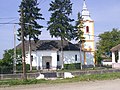
Hungarian Reformed Church in Lunca Mureșului


Web links
Individual evidence
- ↑ 2011 census in Romania ( MS Excel ; 1.3 MB)
- ↑ Mayoral elections 2016 in Romania ( MS Excel ; 256 kB)
- ^ Dictionary of the localities in Transylvania
- ^ Institute Of Archeology - Lunca Mureșului, accessed March 6, 2010 (Romanian).
- ↑ Heinz Heltmann, Gustav Servatius (Ed.): Travel Guide Siebenbürgen. Kraft-Verlag, Würzburg 1993, ISBN 3-8083-2019-2 .
- ^ Lunca Mureșului ( Memento of April 13, 2010 in the Internet Archive ).
- ↑ Census, last updated October 30, 2008, p. 107 (Hungarian; PDF; 1.2 MB).
- ↑ List of historical monuments of the Romanian Ministry of Culture, updated 2010 (PDF; 7.10 MB).
Albac | Almașu Mare | Arieșeni | Avram Iancu | Berghin | Bistra | Blandiana | Bucerdea Grânoasă | Bucium | Câlnic | Cenade | Cergău | Ceru-Băcăinți | Cetatea de Baltă | Ciugud | Ciuruleasa | Crăciunelu de Jos | Cricău | Cut | Daia Română | Doștat | Fărău | Galda de Jos | Gârbova | Gârda de Sus | Hopârta | Horea | Ighiu | Întregalde | Jidvei | Livezile | Lopadea Nouă | Lunca Mureșului | Lupșa | Meteș | Mihalț | Mirăslău | Mogoș | Noșlac | Ocoliș | Ohaba | Pianu | Poiana Vadului | Ponor | Poșaga | Rădeşti | Râmeț | Rimetea | Roșia de Secaș | Roșia Montană | Sălciua | Săliştea | Sâncel | Sântimbru | Săsciori | Scărișoara | Șibot | Sohodol | Șona | Șpring | Stremț | Șugag | Unirea | Vadu Moților | Valea Lunga | Vidra | Vințu de Jos