
Gârda de Sus
|
Gârda de Sus Felsőgirda |
|||||
|
|||||
| Basic data | |||||
|---|---|---|---|---|---|
| State : |
|
||||
| Historical region : | Transylvania | ||||
| Circle : | Alba | ||||
| Coordinates : | 46 ° 27 ' N , 22 ° 50' E | ||||
| Time zone : | EET ( UTC +2) | ||||
| Height : | 729 m | ||||
| Area : | 82.11 km² | ||||
| Residents : | 1,714 (2011) | ||||
| Population density : | 21 inhabitants per km² | ||||
| Postal code : | 517310 | ||||
| Telephone code : | (+40) 02 58 | ||||
| License plate : | FROM | ||||
| Structure and administration (as of 2016) | |||||
| Community type : | local community | ||||
| Structure : | Gârda de Sus, Biharia , Dealu Frumos , Dobreşti , Gârda Seacă , Ghețari , Hănăşeşti , Huzăreşti , Izvoarele , Munună , Ocoale , Plai , Plişti , Scoarța , Snide , Suceşti | ||||
| Mayor : | Marin Vîrciu ( PNL ) | ||||
| Postal address : | Str. Principală, no. 46A loc. Gârda de Sus, jud. Alba, RO-517310 |
||||
| Website : | |||||


Gârda de Sus or old spelling Gîrda de Sus [ ˈgɨrda de sus ] ( Hungarian Felsőgirda ) is a Romanian municipality in the Alba district in Transylvania . It consists of around 15 mostly small settlements.
location

The municipality of Gârda de Sus extends on both sides of the Arieșul Mare - a headwaters of the Arieș - in the Bihor Mountains (Munții Bihorului) , in western Transylvania . Located at Drum național 75 , the place is about 112 kilometers northeast of the district capital Alba Iulia . It is 35 kilometers to the next larger town of Câmpeni . A few kilometers southwest of the village is the highest peak of the Bihor and at the same time the Apuseni mountains , the Cucurbăta Mare ( 1849 m ).
history
The place was first mentioned in 1909 under the Hungarian name Felsőgirda . However, the settlement has existed for a long time. It was part of the large municipality of Râul Mare , first mentioned in 1673 - which included the settlements in the Arieșul Mare valley -, later belonged to the municipality of Scărișoara and only became an independent municipality in 1932. The community was mainly characterized by forestry and grazing.
population
In 2002, the 1865 inhabitants of the municipality called themselves all Romanians . The population decreased significantly in the period after the Second World War (3809 in 1956). This was mainly due to the evacuation of the remote mountain regions.
In 2002, 361 people lived in Gârda de Sus itself. In contrast to the municipality as a whole, the population was largely stable.
Attractions
- The wooden church Nașterea Sfântului Ioan Botezătorul , built in 1781 or 1792 (according to different statements) and rebuilt in 1863, is a listed building.
- In the vicinity of the municipality there are numerous tourist destinations in the Bihor Mountains . The most important of these is the Peştera Scărişoara ice cave near the hamlet of Ghețari . A large shaft, Avenul din Bătrâna , a vertical cave under the peak of the same name.
- The wooden church Sfinții Apostoli Petru și Pavel in the incorporated village of Biharia .
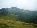
Landscape near Gârda de Sus

Wooden church in Gârda de Sus

Wooden church in Gârda de Sus

Wooden church in Biharia

Altar of the wooden church in Biharia

New church in Gârda de Sus

.JPG)


Web links
Individual evidence
- ↑ Mayoral elections 2016 in Romania ( MS Excel ; 256 kB)
- ↑ Settlement history of the Motzenland ( Memento of the original from October 23, 2007 in the Internet Archive ) Info: The archive link was inserted automatically and has not yet been checked. Please check the original and archive link according to the instructions and then remove this notice.
- ↑ Presentation of the community on their website, accessed on September 12, 2012
- ↑ Census, last updated October 30, 2008, p. 88 (Hungarian; PDF; 1.2 MB)
- ↑ a b Heinz Heltmann, Gustav Servatius (Ed.): Travel Guide Siebenbürgen. Kraft-Verlag, Würzburg 1993, ISBN 3-8083-2019-2 .
- ↑ List of historical monuments of the Romanian Ministry of Culture, updated 2010 (PDF; 7.10 MB)
Albac | Almașu Mare | Arieșeni | Avram Iancu | Berghin | Bistra | Blandiana | Bucerdea Grânoasă | Bucium | Câlnic | Cenade | Cergău | Ceru-Băcăinți | Cetatea de Baltă | Ciugud | Ciuruleasa | Crăciunelu de Jos | Cricău | Cut | Daia Română | Doștat | Fărău | Galda de Jos | Gârbova | Gârda de Sus | Hopârta | Horea | Ighiu | Întregalde | Jidvei | Livezile | Lopadea Nouă | Lunca Mureșului | Lupșa | Meteș | Mihalț | Mirăslău | Mogoș | Noșlac | Ocoliș | Ohaba | Pianu | Poiana Vadului | Ponor | Poșaga | Rădeşti | Râmeț | Rimetea | Roșia de Secaș | Roșia Montană | Sălciua | Săliştea | Sâncel | Sântimbru | Săsciori | Scărișoara | Șibot | Sohodol | Șona | Șpring | Stremț | Șugag | Unirea | Vadu Moților | Valea Lunga | Vidra | Vințu de Jos