
Întregalde
|
Întregalde Koliben Havasgáld |
|||||
|
|||||
| Basic data | |||||
|---|---|---|---|---|---|
| State : |
|
||||
| Historical region : | Transylvania | ||||
| Circle : | Alba | ||||
| Coordinates : | 46 ° 15 ' N , 23 ° 25' E | ||||
| Time zone : | EET ( UTC +2) | ||||
| Height : | 603 m | ||||
| Area : | 82.86 km² | ||||
| Residents : | 577 (2011) | ||||
| Population density : | 7 inhabitants per km² | ||||
| Postal code : | 517365 | ||||
| Telephone code : | (+40) 02 58 | ||||
| License plate : | FROM | ||||
| Structure and administration (as of 2016) | |||||
| Community type : | local community | ||||
| Structure : | Întregalde, Dealu Geoagiului , Ghioncani , Ilieşti , Ivăniş , Mărineşti , Modoleşti , Necrileşti , Popeşti , Sfârcea , Tecşeşti | ||||
| Mayor : | Teodor Florea ( PNL ) | ||||
| Postal address : | Str. Principală, no. 3 loc. Întregalde, jud. Alba, RO-517365 |
||||
| Website : | |||||


Întregalde (outdated Intregălzi, Intre-Galde ; German Koliben , Hungarian Havasgáld or Középgáld ) is a Romanian municipality in the Alba district in Transylvania .
location

Întregalde is located in the Trascău Mountains in western Transylvania. The district capital Alba Iulia is located about 35 kilometers southeast of Întregalde. In a mountainous landscape, the place can be reached via the county road (Drum județean) DJ 107K, which leads from Drum național 1 on the county road 107H through the valley of the Galda river into the Trascău mountains to Mogoş .
history
The oldest surviving mention of the place can be found in a document from 1525.
population
The 877 inhabitants of the municipality designated in 2002 except for two Hungarians throughout as Romanians . The population has decreased significantly since its peak in 1941 (then 2385). The same applies to the actual place Întregalde; here the number of residents fell from 243 to 94 between 1956 and 2002. The highest number of Romanian Germans (3) was counted in 1956, Hungarians (12) in 1910, and Roma (7) in 1930. In 1966 a Slovak was registered.
economy
The place is characterized by pasture farming.
Attractions
- The wooden church , Sf. Ilie from 1774 with interior paintings from 1789, rebuilt in the 19th century, is a listed building.
- The ethnographic museum, opened in 2007.
- In the area there are several valley gorges in which the ridges of the Trascău Mountains are broken by streams, z. B. the Cheile Întregalde , the Cheile Galditei and the Cheile Tecşeştilor . Some of the most famous peaks in the mountains, e.g. B. Vârful Piatra Cetii (1233 m), Măgulicea (1128 m) and Piatra Craivii (1078 m), can be reached in day hikes from Întregalde.
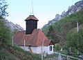
Wooden church Sf. Ilie

Wooden church Sf. Ilie
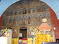
Altar of the wooden church Sf. Ilie
.JPG)
.JPG)
.JPG)
Web links
- Întregalde at ghidulprimariilor.ro
- Information and pictures about the community at www.karpatenwilli.com
Individual evidence
- ↑ Mayoral elections 2016 in Romania ( MS Excel ; 256 kB)
- ^ Dictionary of the localities in Transylvania
- ↑ Heinz Heltmann and Gustav Servatius (eds.): Travel Guide Transylvania . Kraft-Verlag, Würzburg 1993. ISBN 3-8083-2019-2
- ↑ Census, last updated October 30, 2008, p. 99 (Hungarian; PDF; 1.2 MB)
- ↑ List of historical monuments of the Romanian Ministry of Culture, updated 2010 (PDF; 7.10 MB)
Albac | Almașu Mare | Arieșeni | Avram Iancu | Berghin | Bistra | Blandiana | Bucerdea Grânoasă | Bucium | Câlnic | Cenade | Cergău | Ceru-Băcăinți | Cetatea de Baltă | Ciugud | Ciuruleasa | Crăciunelu de Jos | Cricău | Cut | Daia Română | Doștat | Fărău | Galda de Jos | Gârbova | Gârda de Sus | Hopârta | Horea | Ighiu | Întregalde | Jidvei | Livezile | Lopadea Nouă | Lunca Mureșului | Lupșa | Meteș | Mihalț | Mirăslău | Mogoș | Noșlac | Ocoliș | Ohaba | Pianu | Poiana Vadului | Ponor | Poșaga | Rădeşti | Râmeț | Rimetea | Roșia de Secaș | Roșia Montană | Sălciua | Săliştea | Sâncel | Sântimbru | Săsciori | Scărișoara | Șibot | Sohodol | Șona | Șpring | Stremț | Șugag | Unirea | Vadu Moților | Valea Lunga | Vidra | Vințu de Jos