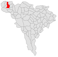
Scărișoara (Alba)
|
Scărișoara Aranyosfő |
||||
|
||||
| Basic data | ||||
|---|---|---|---|---|
| State : |
|
|||
| Historical region : | Transylvania | |||
| Circle : | Alba | |||
| Coordinates : | 46 ° 27 ' N , 22 ° 52' E | |||
| Time zone : | EET ( UTC +2) | |||
| Height : | 700 m | |||
| Area : | 94.41 km² | |||
| Residents : | 1,661 (2011) | |||
| Population density : | 18 inhabitants per km² | |||
| Postal code : | 517680 | |||
| Telephone code : | (+40) 02 58 | |||
| License plate : | FROM | |||
| Structure and administration (as of 2016) | ||||
| Community type : | local community | |||
| Structure : | Scărişoara, Bârleşti , Boteşti , Fața-Lăzeşti , Floreşti , Lăzeşti , Lespezea , Maței , Neceşti , Prelucă , Runc , Sfoartea , Știuleți , Trânceşti | |||
| Mayor : | Cristian-Vasile Costea ( PNL ) | |||
| Postal address : | Str. Centru, no. 205 loc. Scărișoara, jud.Alba, RO – 517680 |
|||
| Website : | ||||
Scărișoara [ ˈskəriʃoara ] (outdated Aradia ; Hungarian Aranyosfő ) is a Romanian municipality in the Alba district in Transylvania .
Geographical location
The municipality Scărișoara is located in the Motzenland , between the foothills of the Bihor (Munții Bihorului) and the Gilău Mountains (Munții Gilăului) . In a small valley widening on the Arieșul Mare - a source river of the Arieș - the place Scărișoara is located on the Drum național 75 about 30 kilometers northwest of Câmpeni (Topesdorf) ; the district capital Alba Iulia (Karlsburg) is about 107 kilometers to the southeast. With its 14 hamlets and villages within a radius of 4 to 12 kilometers, the municipality extends high into the mountains under the peaks of Prelucă (1300 m) and Runc (1340 m), on an area of 9441 hectares. About 20% of the area (1968 ha) is cultivated; 7035 hectares (74.5%) are forests.
history
The place Scărișoara was first mentioned in a document in 1733 or 1850 (according to different information) under the Hungarian name Sczerisora . However, the settlement has existed for a long time. It was part of the large community Râul Mare (ung. "Nagy Aranyos"), which was first mentioned in 1673 and which included the settlements in the Arieșul Mare valley. According to Gabriel Téglás, finds have been made in the area of today's municipality along the Scărișoara stream , which point to stamping mills for gold panning from Roman times .
Because of severe clear cuts in the area of the municipality, there have been repeated floods since 1998 - in spring and also in autumn. On about 10 kilometers along the Arieșul Mare and in the inflow area of the Popaselor and Vâlcea brooks , the change in the course of the river is increasingly observed. The national road DN75 is also affected by landslides due to flooding in the municipality's area.
In the current (2010) composition of the places, the municipality has existed since March 1, 1968.
The main occupations of the population are cattle breeding, wood processing and arts and crafts.
population
In the official survey of 1850, 3488 inhabitants (3482 Romanians and 6 Roma ) were registered in the area of today's municipality . The highest number of inhabitants (6275) of today's municipality and at the same time that of the Romanians (6,246) was determined in 1910 and has decreased dramatically since then. The highest population of Hungarians (15) was registered in 1910 and that of Roma (227) in 2002. Germans were registered in 1880, 1956 and 1992 (one each) and 1890 and 1900 (two each). In 2002 there were still 1850 people living in the area of today's parish; 1622 were Romanians, one Hungarian and 227 were Roma.
Attractions
There are numerous tourist destinations in the karst area in the vicinity of the municipality:
- The ice cave Peştera Scărişoara near Ghețari , which is part of the municipality of Gârda de Sus (ung. Felsőgirda ).
- The Cheile Mândruțului Nature Reserve
- The 4 kilometer long Zugai Gorge and a waterfall between Scărișoara and Albac .
- The Scărișoara – Belioara botanical nature reserve
- The Romanian Orthodox Church of the place.
Web links
Individual evidence
- ↑ Mayoral elections 2016 in Romania ( MS Excel ; 256 kB)
- ^ Dictionary of the localities in Transylvania
- ↑ a b Heinz Heltmann, Gustav Servatius (Ed.): Travel Guide Siebenbürgen. Kraft-Verlag, Würzburg 1993, ISBN 3-8083-2019-2
- ↑ a b c d e Scărișoara community website, accessed June 3, 2010
- ↑ Information on Scărișoara ( memento of April 13, 2010 in the Internet Archive ) at sate-comune.ro (Romanian).
- ^ Settlement history of Motzenland ( Memento from October 23, 2007 in the Internet Archive )
- ^ Gabriel Téglás: Studies on the Dacian gold mining of the Romans. In: Hungarian Review. Vol. 9, 1889, ISSN 0200-2760 , p. 330.
- ^ Institute Of Archeology - Scărișoara, accessed June 3, 2010 (Romanian)
- ↑ Census, last updated October 30, 2008, p. 160 (Hungarian; PDF file; 1.14 MB)


