
Arieșeni
|
Arieșeni Lepus |
|||||
|
|||||
| Basic data | |||||
|---|---|---|---|---|---|
| State : |
|
||||
| Historical region : | Transylvania | ||||
| Circle : | Alba | ||||
| Coordinates : | 46 ° 29 ' N , 22 ° 45' E | ||||
| Time zone : | EET ( UTC +2) | ||||
| Height : | 859 m | ||||
| Area : | 63.10 km² | ||||
| Residents : | 1,765 (October 20, 2011) | ||||
| Population density : | 28 inhabitants per km² | ||||
| Postal code : | 517040 | ||||
| Telephone code : | (+40) 02 58 | ||||
| License plate : | FROM | ||||
| Structure and administration (as of 2016) | |||||
| Community type : | local community | ||||
| Structure : | Arieşeni, Avrămeşti , Bubesti , Casa de Piatra , cobles , Dealu Bajului , Fata Cristesei , Fata Lapusului , Galbena , Hodobana , Izlaz , Pănteşti , Patrahaitesti , POIENITA , Raviceşti , Ştei-Arieşeni , Sturu , Vanvuceşti | ||||
| Mayor : | Vasile-Marin Jurj ( PSD ) | ||||
| Postal address : | Str. Principală, no. 16 loc. Sat Arieșeni, jud. Alba, RO-517040 |
||||
| Website : | |||||


Arieșeni ( Hungarian Lepus ) is a Romanian municipality in the Alba district in Transylvania .
location

The municipality extends over the area of origin of the Arieșul Mare river - a headwaters of the Arieș - in the Bihor Mountains ( Rum. Munții Bihorului ), in western Transylvania . The next town of Câmpeni is 40 kilometers away and the district capital Alba Iulia is about 120 kilometers away (both to the southeast). A few kilometers southwest of the village is the highest peak of the Bihor and at the same time the Apuseni Mountains , the Curcubăta Mare , at 1849 meters.
history
The village was first mentioned in 1909 under the name Lepus . However, the settlement has existed for a long time. It was part of the large community of Râul Mare , first mentioned in 1673 - which included the hamlets in the Arieșul Mare valley - and was mainly characterized by forestry and grazing.
population
In 1930, residents lived in the area of the present-day town in 2020. In 2002, the 1921 inhabitants of the municipality in the 18 mostly small settlements referred to themselves as Romanians . The population has decreased significantly since its peak in 1966 (then 2990).
In 2002, 98 people lived in Arieșeni itself.
traffic
Arieșeni is located on Drum național 75 from Turda (Thorenburg) to Ștei (Hungarian Vaskohsziklás ). This leads west of the village over the Vârtop Pass ( 1160 m ), which is an important connection between the Kreisch area and Transylvania.
Attractions
- The wooden church Înălțarea Domnului , built in 1791 , has an important collection of wooden and reverse glass icons . Today covered with a tin roof, the church is a listed building.
- In the vicinity of the municipality there are numerous tourist destinations in the Bihor Mountains .

Surroundings of Arieşeni
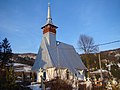
Arieşeni wooden church

Interior of the wooden church
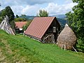
Farm in the municipality of Galbena


Individual evidence
- ↑ 2011 census in Romania ( MS Excel ; 1.3 MB)
- ↑ Mayoral elections 2016 in Romania ( MS Excel ; 256 kB)
- ↑ http://www.sate-comune.ro/descriere_comuna.php?comuna=Arieseni ( Memento from April 13, 2010 in the Internet Archive ) Arieșeni, on www.sate-comune.ro, accessed on April 13, 2010 (Romanian )
- ↑ Settlement history of the Motzenland ( Memento of the original from October 23, 2007 in the Internet Archive ) Info: The archive link was inserted automatically and has not yet been checked. Please check the original and archive link according to the instructions and then remove this notice.
- ↑ Census, last updated October 30, 2008, p. 38 (Hungarian; PDF; 1.2 MB)
- ↑ List of historical monuments of the Romanian Ministry of Culture, updated 2010 (PDF; 7.10 MB)
Web links
Albac | Almașu Mare | Arieșeni | Avram Iancu | Berghin | Bistra | Blandiana | Bucerdea Grânoasă | Bucium | Câlnic | Cenade | Cergău | Ceru-Băcăinți | Cetatea de Baltă | Ciugud | Ciuruleasa | Crăciunelu de Jos | Cricău | Cut | Daia Română | Doștat | Fărău | Galda de Jos | Gârbova | Gârda de Sus | Hopârta | Horea | Ighiu | Întregalde | Jidvei | Livezile | Lopadea Nouă | Lunca Mureșului | Lupșa | Meteș | Mihalț | Mirăslău | Mogoș | Noșlac | Ocoliș | Ohaba | Pianu | Poiana Vadului | Ponor | Poșaga | Rădeşti | Râmeț | Rimetea | Roșia de Secaș | Roșia Montană | Sălciua | Săliştea | Sâncel | Sântimbru | Săsciori | Scărișoara | Șibot | Sohodol | Șona | Șpring | Stremț | Șugag | Unirea | Vadu Moților | Valea Lunga | Vidra | Vințu de Jos