
Gârbova
|
Gârbova Urwegen Szászorbó |
|||||
|
|||||
| Basic data | |||||
|---|---|---|---|---|---|
| State : |
|
||||
| Historical region : | Transylvania | ||||
| Circle : | Alba | ||||
| Coordinates : | 45 ° 52 ' N , 23 ° 43' E | ||||
| Time zone : | EET ( UTC +2) | ||||
| Height : | 359.7 m | ||||
| Area : | 58.93 km² | ||||
| Residents : | 2,050 (2011) | ||||
| Population density : | 35 inhabitants per km² | ||||
| Postal code : | 517305 | ||||
| Telephone code : | (+40) 02 58 | ||||
| License plate : | FROM | ||||
| Structure and administration (as of 2016) | |||||
| Community type : | local community | ||||
| Structure : | Gârbova, Cărpiniș , Reciu | ||||
| Mayor : | Ioan Nedela ( PNL ) | ||||
| Postal address : | Str. Văii, no. 452 loc. Gârbova, jud. Alba, RO-517305 |
||||
| Website : | |||||


Gârbova or old spelling Gîrbova [ ˈgɨrbova ] ( German Urwegen , Hungarian Szászorbó ) is a Romanian community in the Alba district in Transylvania .
The place Gârbova was also named under the names: Orbo (1309), Orbow (1330), Wrbegen (1496), Urbogen (1500), Urbeygen (1568), Urbigen (1603), Uhrbegen (1696, on a chalice of the parish ), Gerbova (1733, first Romanian name), Szász Orbó (1760, first Hungarian name) and in 1854 with Gîrbova - Urwegen - Szász Orbó (in the three languages of Transylvania), mentioned.
Geographical location

The community lies between the foothills of the Munții Șureanu (Mühlbacher Berge) and the Zibinsgebirge (Munții Cindrel) in the under forest and thus in the extreme southeastern part of the Alba district . The place is located on the river Gârbova and the county road (Drum județean) DJ 106F, is 6 kilometers from the European route 68 (between Sebeş and Sibiu ). It is 11 kilometers to the next larger city Miercurea Sibiului ( Sibiu County ); the district capital Alba Iulia is located about 39 kilometers northwest.
history
Various archaeological finds (starting from the Neolithic ) show that the area was inhabited for a long time.
The place was originally inhabited by Transylvanian Saxons . It was first mentioned in 1291 under the name Wrbow .
In the Middle Ages the place was owned by the Weissenburg Cathedral Chapter afterwards a free Saxon chair community on Königsboden . Around 1500 Urwegen was the second largest community in the Reussmarkter Stuhl , one of the Seven Chairs in Transylvania.
Due to the local specialization in viticulture , the phylloxera infestation of 1898 hit Gârbova particularly hard. Many residents subsequently emigrated to the USA .
In 1968 the village, which until then was administratively oriented more towards Miercurea Sibiului ( Reuss market ), was attached to the Alba district, to which it still belongs today. Far beyond the borders of the Alba district, the village is known to this day for its wine ( see: Viticulture in Romania ) and cognac .
population
The population of the municipality developed as follows:
| census | Ethnic composition | |||||||
|---|---|---|---|---|---|---|---|---|
| year | population | Romanians | Hungary | German | other | |||
| 1850 | 2,906 | 1,569 | - | 1,080 | 257 | |||
| 1930 | 3,729 | 2,320 | 5 | 1,339 | 65 | |||
| 1956 | 3,647 | 2,197 | 3 | 1,095 | 352 | |||
| 1977 | 3,241 | 1,889 | 3 | 1,178 | 171 | |||
| 1992 | 2,067 | 1,768 | 7th | 85 | 207 | |||
| 2002 | 2,059 | 1,848 | 6th | 41 | 164 | |||
While in the village itself and in the incorporated village of Reciu ( Rätsch ) from the census of 1850 to 1977 about half of the population were Transylvanian Saxons , in the village of Cărpiniș ( Keppelsbach ) lived almost exclusively Romanians.
The highest population (3892) of today's municipality was determined in 1941, that of the Romanians (2335) in 1930, the Germans (1407) in 1941, the Magyars (13) in 1910 and that of the Roma (347) in 1956. In 1956 a Serb , One Croat registered each in 1890/1900 .
During the Second World War , of 116 men who had been drafted into the German Wehrmacht , 36 Saxons fell on various fronts. In January 1945 106 women and 68 men were deported to the Soviet Union for forced labor and most of them were only released after 5 years. 9 women and 11 men died in the labor camps .
Attractions
- The Graefenburg , built at the end of the 13th century. Today's bell tower was a residential tower and donjon , in the meantime also served as a school and parish apartment; later it was used exclusively to store the bacon. It is a listed building.
- The Evangelical Lutheran Church in the town center (built around 1500) is a Gothic hall church with frescoes in the choir. In 1879 a new bell tower (60 m) with a tower clock was built.
- The mountain church , built in 1280 and converted into a fortified church in the 15th century , is the ruins of a Romanesque basilica after a fire in 1870 (the roof and aisles of the church were removed in 1872). A memorial plaque commemorates the legend of the “Bride of Urwege” . It is a listed building.
- The Old Castle (Cetatea Urieșilor) - a medieval hilltop castle, built in the 14th century - is a ruin about 2 kilometers south of the town of Gârbova and is a listed building.
- The Romanian Orthodox Church

Gârbova in the Josephinian land survey from 1767–1773
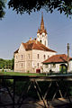
Gârbova town hall and bell tower

The mountain church of Gârbova
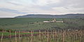
The mountain church of Gârbova

Entrance to Gârbova


Web links
Individual evidence
- ↑ Mayoral elections 2016 in Romania ( MS Excel ; 256 kB)
- ↑ a b c Urweg history, on the Urweg neighborhood homepage
- ^ Institute Of Archeology - Gârbova, accessed February 14, 2010 (Romanian)
- ↑ a b c d Heinz Heltmann, Gustav Servatius (Ed.): Travel Guide Siebenbürgen. Kraft-Verlag, Würzburg 1993, ISBN 3-8083-2019-2 .
- ↑ Census, last updated October 30, 2008, p. 87 (Hungarian; PDF; 1.2 MB)
- ↑ Short film from September 25, 2009 about the Speckturm, www.realitatea.net (Romanian)
- ↑ a b c List of historical monuments of the Romanian Ministry of Culture, updated 2010 (PDF; 7.10 MB)
Albac | Almașu Mare | Arieșeni | Avram Iancu | Berghin | Bistra | Blandiana | Bucerdea Grânoasă | Bucium | Câlnic | Cenade | Cergău | Ceru-Băcăinți | Cetatea de Baltă | Ciugud | Ciuruleasa | Crăciunelu de Jos | Cricău | Cut | Daia Română | Doștat | Fărău | Galda de Jos | Gârbova | Gârda de Sus | Hopârta | Horea | Ighiu | Întregalde | Jidvei | Livezile | Lopadea Nouă | Lunca Mureșului | Lupșa | Meteș | Mihalț | Mirăslău | Mogoș | Noșlac | Ocoliș | Ohaba | Pianu | Poiana Vadului | Ponor | Poșaga | Rădeşti | Râmeț | Rimetea | Roșia de Secaș | Roșia Montană | Sălciua | Săliştea | Sâncel | Sântimbru | Săsciori | Scărișoara | Șibot | Sohodol | Șona | Șpring | Stremț | Șugag | Unirea | Vadu Moților | Valea Lunga | Vidra | Vințu de Jos