
Mogoș
|
Mogoș Mogos |
|||||
|
|||||
| Basic data | |||||
|---|---|---|---|---|---|
| State : |
|
||||
| Historical region : | Transylvania | ||||
| Circle : | Alba | ||||
| Coordinates : | 46 ° 16 ' N , 23 ° 17' E | ||||
| Time zone : | EET ( UTC +2) | ||||
| Height : | 792 m | ||||
| Area : | 81.33 km² | ||||
| Residents : | 731 (October 20, 2011) | ||||
| Population density : | 9 inhabitants per km² | ||||
| Postal code : | 517480 | ||||
| Telephone code : | (+40) 02 58 | ||||
| License plate : | FROM | ||||
| Structure and administration (as of 2016) | |||||
| Community type : | local community | ||||
| Structure : | Mogos, Bărbeşti , Bârleşti , Bârleşti-Catun , Bârzogani , Boceşti , Bogdăneşti , Buteşti , Cojocani , Cristeşti , Mămăligani , Negreşti , Onceşti , Poienile-Mogos , Tomeşti , Valea Bârluţeşti , Valea Barnii , Valea Coceşti , Valea Giogeşti , Valea Mlacii , Valea Țupilor | ||||
| Mayor : | Mircea Liviu Macavei ( PNL ) | ||||
| Postal address : | Str. Principală, no. 3A loc. Mogoș, jud. Alba, RO-517480 |
||||


Mogoş (outdated Mogoş-Micleşti or Micleşti ; German Mogos ) is a Romanian community in the Alba district in Transylvania .
Geographical location

The place Mogoș is located on the stream of the same name in the Transylvanian Ore Mountains ( Romanian Munții Metaliferi ) in western Transylvania, in the southeastern part of the historic Motzenland . The nearest small town Abrud is about 27 kilometers to the west; the district capital Alba Iulia (Karlsburg) 32 kilometers (as the crow flies) southeast of Mogoș. With its 21 incorporated villages and hamlets , the municipality covers an area of 8,133 hectares on the upper reaches of the Geoagiu (Gyogy) river , a tributary of the Mureș (Mieresch) .
history
The place was first mentioned in 1760 under the name Mogoş-Micleşti . Since then, it has been shaped by pasture farming.
population
With the exception of two people (one Hungarian and one Rome ), the 1114 inhabitants of the municipality referred to themselves as Romanians in 2002 . The number of inhabitants remained more or less constant from the first official survey in 1850 (then 2815) until the mid-1960s and has decreased significantly since then. Only 109 (as of 2002) people live in the central town of Mogoș, the rest in the 20 incorporated, small scattered settlements in the area. The highest number of inhabitants (3415) was registered in 1941.
traffic
Mogoș is located on the unpaved road between Aiud ( Strasbourg am Mieresch ) and Abrud ( Großschlatten ). There is a bus connection to the district capital Alba Iulia once a day (as of 2008).
Attractions
- Mogoș itself has no special features. In the incorporated villages of Bârleşti (Hungarian Mogosbirlesty ) and Cojocani (Hungarian Mogoskozsokány ) are the wooden churches Sf. Împărați Constantin și Elena built in 1844, or the Sf. Arhangheli built 1700–1769 and renovated at the beginning of the 19th century, both are listed buildings.
- The scenic location of the municipality is of tourist interest.

Mogoș
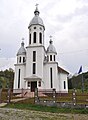
Church in Mogoș

Wooden church in Cojocani

Wooden church in Bârleşti

Older Motzenhaus in Bârleşti


Web links
Individual evidence
- ↑ 2011 census in Romania ( MS Excel ; 1.3 MB)
- ↑ Mayoral elections 2016 in Romania ( MS Excel ; 256 kB)
- ^ Dictionary of the localities in Transylvania
- ↑ Mogoș ( Memento of April 13, 2010 in the Internet Archive )
- ↑ Census, last updated October 30, 2008, p. 121 (Hungarian; PDF; 1.2 MB)
- ↑ List of historical monuments of the Romanian Ministry of Culture, updated 2010 (PDF; 7.10 MB)
Albac | Almașu Mare | Arieșeni | Avram Iancu | Berghin | Bistra | Blandiana | Bucerdea Grânoasă | Bucium | Câlnic | Cenade | Cergău | Ceru-Băcăinți | Cetatea de Baltă | Ciugud | Ciuruleasa | Crăciunelu de Jos | Cricău | Cut | Daia Română | Doștat | Fărău | Galda de Jos | Gârbova | Gârda de Sus | Hopârta | Horea | Ighiu | Întregalde | Jidvei | Livezile | Lopadea Nouă | Lunca Mureșului | Lupșa | Meteș | Mihalț | Mirăslău | Mogoș | Noșlac | Ocoliș | Ohaba | Pianu | Poiana Vadului | Ponor | Poșaga | Rădeşti | Râmeț | Rimetea | Roșia de Secaș | Roșia Montană | Sălciua | Săliştea | Sâncel | Sântimbru | Săsciori | Scărișoara | Șibot | Sohodol | Șona | Șpring | Stremț | Șugag | Unirea | Vadu Moților | Valea Lunga | Vidra | Vințu de Jos