
Altenburg (Reuschberg)
| Altenburg | ||
|---|---|---|
 The Altenburg stables on the summit of the Reuschberg |
||
| Alternative name (s): | Old castle | |
| Creation time : | 10th or 11th century | |
| Castle type : | Höhenburg, spur location | |
| Conservation status: | Castle stable, ring wall with moat preserved | |
| Place: | Community-free area Schöllkrippener Forst - " Reuschberg " | |
| Geographical location | 50 ° 5 '19.8 " N , 9 ° 16' 10.1" E | |
| Height: | 422 m above sea level NN | |
|
||

The Altenburg or " Old Castle " was once a medieval hilltop castle in the Bavarian Spessart . It was on the summit of the Reuschberg east of Schöllkrippen . All that remains of the castle today is a stable with a ring wall . At the beginning of the 20th century you could still see whole stone walls, but they fell victim to the stone robbery in the 1960s.
Geographical location

The castle stable of the Spornburg is located about 1650 meters east-northeast of the Catholic parish church Sankt Lukas in Schöllkrippen on a foothill of the Geiershöhe facing west, 414.6 m above sea level. NN high Reuschberg. The former castle complex is now in the community-free area of Schöllkrippener Forst , in the state forest department V, 9a Altenburg and 10a Reuschberg.
The Reuschberg, which is now completely forested, drops steeply around 200 meters in altitude down to the east side into the surrounding valleys of the Laudenbach , the Kahl and the Höllenbach . In the east, the mountain turns into a saddle a few meters lower , which first runs to the east and then bends to the south-east, then to 490 m above sea level. NN high Geiershöhe to climb.
Other former castles in the area are the Landesehre castles on the Graefenberg and Waldenberg Castle on the Klosterberg near Rottenberg , located in a south-southwestern direction . In a west-southwest direction there is an unknown castle stables on the mountain called Kalmus , a little further the Hauenstein castle ruins and the lost Mömbris castle on the cemetery in Mömbris .
history

For a long time it was believed that the Altenburg and the ring wall were of Celtic origin, but after an excavation in 2005, doubts arose. No objects from prehistoric times were found , but some ceramic objects from the 11th and 12th centuries. At around 1300 square meters, the topographical comparison with other fortifications makes the complex rather small and suggests a medieval origin.
The earth wall up to one meter high in places was probably built very quickly, which suggests that the Altenburg is a provisional fortification. Because even the lack of evidence of permanent interior development implies a limited use as a refuge in times of political unrest . The origins of the ramparts may be traced back to the turbulent times of the Hungarian invasions . A prehistoric origin of the Altenburg can be excluded.
description
The castle site at the summit of the Reuschberg appears as an oval ring wall with an east-west diameter of around 50 meters, from north to south the width of the fortification is around 40 meters.
The ring wall is on average about 0.50 meters high, on the south and east sides it still reaches a height of one meter. A two-meter-wide and just as deep ring trench is laid before this wall, which in turn is followed by a flattened outer wall. On the steep north side of the Reuschberg, however, the ditch and the outer wall are exposed. The earlier access to the medieval fortification was probably in the area of a modern path breakthrough in the west of the complex.

View of the moat to the south
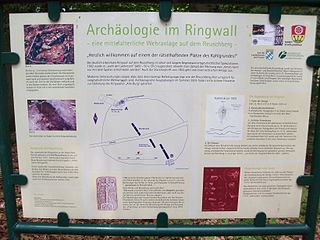
The information board in the center of the castle stables

Stone fragments on the moat at the entrance to the castle excavated in 2005


literature
- Björn-Uwe Abels : The prehistoric and early historical site monuments of Lower Franconia . (Material booklets on Bavarian prehistory, series B, volume 6). Verlag Michael Lassleben, Kallmünz 1979, ISBN 3-7847-5306-X , p. 68.
Web links
Individual evidence
- ↑ Our Kahlgrund 2007 . Homeland yearbook for the Alzenau district. Published by the working group for homeland research and homeland maintenance of the Alzenau district, district administrator. ISSN 0933-1328 .
- ↑ Source description: Björn-Uwe Abels: The prehistoric and early historical terrain monuments of Lower Franconia , p. 68

Castles: Emmerichshofen Castle | Geiselbach Castle (exited) | Luitpoldshöhe Castle | Maisenhausen Castle | Mespelbrunn Palace | Michelbach Castle | Rohrbrunn Palace | Rothenbuch Castle | Schöllkrippen Castle | Unterbessenbach Castle | Wasserlos Castle | Weiler Castle | Weyberhöfe Castle | Castle meadows
Castles and ruins: Alzenau Castle | Hauenstein castle ruins | Burgstall Ketzelburg | Burgstall Kugelburg | Mömbris Castle | Burg Mole (Burg Molen) | Randenburg castle ruins | Burgstall Unterschnorrhof | Burgstall Wahlmich
Castle stables (lost or unknown castles): Burgstall Altenburg | Burgstall Graefenberg | Burgstall Haibach | Burgstall Kalmus | Burgstall Klosterberg | Ringwall Schanzenkopf | Burgstall Forgotten Castle | Burgstall Womburg
Fortified churches: Fortified church Hessenthal (Unsrer Lieben Frau) | Hörstein fortified church (Assumption of Mary)