
Amazon (Venezuela)
| Amazon | |||
|---|---|---|---|
 .svg) |
|||
| Symbols | |||
|
|||
| Basic data | |||
| Country | Venezuela | ||
| Capital | Puerto Ayacucho | ||
| surface | 180,145 km² | ||
| Residents | 136,506 (2005) | ||
| density | 0.8 inhabitants per km² | ||
| ISO 3166-2 | VE-Z | ||
| Website | www.amazonas.gob.ve (Spanish) | ||
| politics | |||
| governor | Liborio Guarulla | ||
| Political party | Patria Para Todos | ||


Coordinates: 3 ° 30 ′ N , 66 ° 0 ′ W
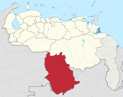
Amazonas is the second largest state in Venezuela in terms of area, with a share of around 19.4% of the total area of the country. The capital of this state is Puerto Ayacucho . Until 1928 this was San Fernando de Atabapo . Although the state is named after the Amazon , most of it is in the Orinoco area .
Administrative division
.svg)
The state of Amazonas is divided into the following districts ( Municipios ):
| district | Seat of government | Area km² |
Population 2008 |
Population density |
|---|---|---|---|---|
| Alto Orinoco | La Esmeralda | 49,217 | 14,222 | |
| Atabapo | San Fernando de Atabapo | 25,062 | 12,797 | |
| Atures | Puerto Ayacucho | 7,302 | 91,386 | |
| Autana | Isla Ratón | 12,291 | 8,181 | |
| Manapiare | San Juan de Manapiare | 32,042 | 9,658 | |
| Maroa | Maroa | 13,082 | 8,181 | |
| Río Negro | San Carlos de Río Negro | 37.903 | 9,658 |
National anthem
States:
Amazonas |
Anzoátegui |
Apure |
Aragua |
Barinas |
Bolívar |
Carabobo |
Cojedes |
Delta Amacuro |
Falcón |
Guárico |
Vargas (La Guaira) |
Lara |
Mérida |
Miranda |
Monagas |
Nueva Esparta |
Portuguesa |
Sucre |
Táchira |
Trujillo |
Yaracuy |
Zulia
Capital District :
Distrito Capital
Federal immediate area:
Dependencias Federales