
Preetz Land Office
| coat of arms | Germany map | |
|---|---|---|

|
Coordinates: 54 ° 14 ' N , 10 ° 18' E |
|
| Basic data | ||
| State : | Schleswig-Holstein | |
| Circle : | Plön | |
| Area : | 191.01 km 2 | |
| Residents: | 9228 (Dec. 31, 2019) | |
| Population density : | 48 inhabitants per km 2 | |
| License plate : | PLÖ | |
| Office key : | 01 0 57 5747 | |
| Office structure: | 17 municipalities | |
| Office administration address : |
Am Berg 2 24211 Schellhorn |
|
| Website : | ||
| Head of Office : | Kai Johanssen (SWG) | |
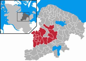
| Location of the Preetz-Land office in the Plön district | ||
  |
||

The Preetz-Land office is an office in the Plön district in Schleswig-Holstein . The seat of the official administration is in the community of Schellhorn .
The administrative area is characterized by agriculture and tourism . Tourism is specifically promoted by the administration. This is how the Barkauer Land and Schusteracht tourism concepts have emerged in recent years .
Official municipalities
(Population as of December 31, 2007)
|
Culture and sights
Buildings and monuments
Leisure and Tourism
The two loops of the Schusteracht run through the entire official area . Water hiking on the Schwentine , which stretches largely through the official area.
In the municipality of Wahlstorf there is a campsite on the southern bank of the Lanker See .
Regular events
- The Schusteracht festival, the Schusteracht spectacle .
- Various village festivals of the official municipalities.
Economy and Infrastructure
traffic
The official area extends around the city of Preetz . The federal highway 76 crosses the administrative area in a north-south direction. The state road 211 leads south of the Schwentine from Preetz via Rastorf to the federal road 202 in the direction of Schönberg.
education
Together with the city of Preetz, the school education tasks are carried out by the school association Preetz Stadt und Land . There are various primary schools in the individual communities and the city, as well as secondary schools in the city.
Web links
Individual evidence
- ↑ North Statistics Office - Population of the municipalities in Schleswig-Holstein 4th quarter 2019 (XLSX file) (update based on the 2011 census) ( help on this ).