Honey lake
| coat of arms | Germany map | |
|---|---|---|

|
Coordinates: 54 ° 14 ' N , 10 ° 11' E |
|
| Basic data | ||
| State : | Schleswig-Holstein | |
| Circle : | Plön | |
| Office : | Preetz country | |
| Height : | 43 m above sea level NHN | |
| Area : | 11.27 km 2 | |
| Residents: | 467 (Dec. 31, 2019) | |
| Population density : | 41 inhabitants per km 2 | |
| Postal code : | 24211 | |
| Area code : | 04302 | |
| License plate : | PLÖ | |
| Community key : | 01 0 57 031 | |
| LOCODE : | DE 66E | |
| Office administration address: | Am Berg 2 24211 Schellhorn |
|
| Website : | ||
| Mayor : | Rainer Hingst (WGH) | |
| Location of the community of Honigsee in the district of Plön | ||
Honigsee is a municipality in the Barkauer Land region in the Plön district in Schleswig-Holstein . Holz, Kleinhavighorst and Großhavighorst ( together called Havighorst on the town sign ) are located in the municipality.
Geography and traffic
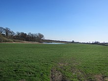
Honigsee is located about 7 km south of Kiel and about 5 km west of Preetz near the federal highway 404 from Kiel to Bad Segeberg . The place is located on the Honigau and the Honigsee. From 1910 to 1930, Honigsee was the railway station of the Kleinbahn Kirchbarkau – Preetz – Lütjenburg .
history
The place name comes from Slavonic . The savings and loan bank founded in 1861 for the monastic Preetz forest district, Honigsee was integrated into the Sparkasse Kreis Plön in 1923 , which is now part of the Förde Sparkasse .
politics
Community representation
Since the local elections in 2008, the WGH community of voters has all nine seats in the local council.
coat of arms
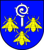
Blazon : "In blue above a broken silver crook, next to it and downwards three golden bees 2: 1."
economy
The municipal area is mainly used for agriculture. Many residents commute to Kiel. The first local heating network with a cooperative organizational form in Schleswig-Holstein supplies 54 households in the village of Honigsee with thermal energy from the block-type thermal power station of a biogas plant .
Web links
Individual evidence
- ↑ North Statistics Office - Population of the municipalities in Schleswig-Holstein 4th quarter 2019 (XLSX file) (update based on the 2011 census) ( help on this ).
- ↑ a b Schleswig-Holstein topography. Vol. 5: Holt - Krokau . 1st edition Flying-Kiwi-Verl. Junge, Flensburg 2005, ISBN 978-3-926055-79-8 , pp. 14 ( dnb.de [accessed on July 18, 2020]).
- ↑ Schleswig-Holstein's municipal coat of arms
- ↑ Energieversorgung Honigsee eG , accessed on February 22, 2010.


