
Driving (Plön district)
| coat of arms | Germany map | |
|---|---|---|

|
Coordinates: 54 ° 21 ' N , 10 ° 20' E |
|
| Basic data | ||
| State : | Schleswig-Holstein | |
| Circle : | Plön | |
| Office : | Probstei | |
| Height : | 25 m above sea level NHN | |
| Area : | 3.6 km 2 | |
| Residents: | 129 (Dec. 31, 2019) | |
| Population density : | 36 inhabitants per km 2 | |
| Postal code : | 24253 | |
| Area code : | 04344 | |
| License plate : | PLÖ | |
| Community key : | 01 0 57 018 | |
| Office administration address: | Knüll 4 24217 Schönberg |
|
| Website : | ||
| Mayor : | Heino Schnoor (KWF) | |
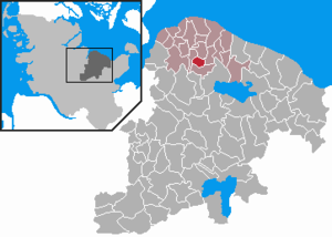
| Location of the municipality of Fahren in the district of Plön | ||
  |
||

Driving is a community in the provost in the Plön district in Schleswig-Holstein . Fahrermühlen and Krüsbrook are in the municipality.
Geography and traffic
Driving is about 15 km east of Kiel on the east bank of the Passader See . The federal highway 502 runs from Kiel to Schönberg (Holstein) about 5 km north of driving and the federal highway 202 , which connects Kiel with Lütjenburg , about 17 km south .
history
Archaeological finds show that the area was already inhabited in the Mesolithic . The place was first mentioned in 1240 under its then Slavic name Warnow. From 1388 to 1873 it belonged to the Preetz monastery .
The Fahrener Mühle, an earth Dutchman , was built in 1882 and demolished again in 1962.
Community representation
The 2018 election resulted in the following:
- KWF : 7
economy
The community area is predominantly agricultural, many of the residents also commute to Kiel or Schönberg .
Attractions
In the center of the village there is a small collection of historical stones that were gathered from the area.
photos
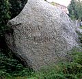
Feldstein for the 750th anniversary of the town (with the inscription WARNOW 1240 1990 FAHREN )

Some of the stones placed in driving

Explanation board for the set up path stones


Web links
Individual evidence
- ↑ North Statistics Office - Population of the municipalities in Schleswig-Holstein 4th quarter 2019 (XLSX file) (update based on the 2011 census) ( help on this ).
- ↑ Schleswig-Holstein topography. Vol. 3: Ellerbek - Groß Rönnau . 1st edition Flying-Kiwi-Verl. Junge, Flensburg 2003, ISBN 978-3-926055-73-6 , p. 80 ( dnb.de [accessed on April 21, 2020]).

Cities: Lütjenburg | Plön | Preetz | Schwentinental .
Other municipalities: Ascheberg (Holstein) | Barman | Barsbek | Behrensdorf (Baltic Sea) | Belau | Bendfeld | Blekendorf | Boksee | Bönebüttel | Bösdorf | Bothkamp | Brodersdorf | Dannau | Dersau | Dobersdorf | Dörnick | Driving | Fargau-Pratjau | Fiefbergen | Giekau | Grebin | Großbarkau | Grand Harrie | Heikendorf | Helmstorf | Högsdorf | Hohenfelde | Höhndorf | Hohwacht (Baltic Sea) | Honey lake | Calves | Kirchbarkau | Kirchnüchel | Klamp | Klein Barkau | Kletkamp | Köhn | Krokau | Krummbek | Cooling | Laboe | Lammershagen | Lebrade | Lehmkuhlen | Löptin | Lutterbek | Martensrade | Mönkeberg | Mucheln | Took | Nettelsee | Panker | Passade | Pohnsdorf | Post field | Prasdorf | Probsteierhagen | Rantzau | Rastorf | Rathjensdorf | Rendswühren | Angle of rest | Schellhorn | Schillsdorf | Reading | Schönberg (Holstein) | Schönkirchen | Schwartbuck | Selent | Stakendorf | Stone | Stumble | Stoltenberg | Tasdorf | Trundle | Wahlstorf | Wankendorf | Warnau | Wendtorf | Wipe | Wittmoldt .