
Cooling
| coat of arms | Germany map | |
|---|---|---|

|
Coordinates: 54 ° 12 ' N , 10 ° 16' E |
|
| Basic data | ||
| State : | Schleswig-Holstein | |
| Circle : | Plön | |
| Office : | Preetz country | |
| Height : | 21 m above sea level NHN | |
| Area : | 16.81 km 2 | |
| Residents: | 604 (Dec. 31, 2019) | |
| Population density : | 36 inhabitants per km 2 | |
| Postal code : | 24211 | |
| Area code : | 04342 | |
| License plate : | PLÖ | |
| Community key : | 01 0 57 042 | |
| LOCODE : | DE 66H | |
| Office administration address: | Am Berg 2 24211 Schellhorn |
|
| Website : | ||
| Mayoress : | Gisela Rinck (KVK) | |
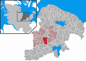
| Location of the municipality of Kühren in the district of Plön | ||
  |
||

Kühren is a municipality in the Plön district in Schleswig-Holstein .
geography
The municipality of Kühren borders on the city of Preetz in the north and on the municipality of Löptin in the west ; the eastern border to the urban area of Preetz is described by the Lanker See and the adjacent Gut Wahlstorf . In the south it borders on the Bundhorst and Depenau estates in the municipality of Stolpe .
The present-day municipality of Kühren largely comprises the area of the former Kühren manor district and today consists of three districts: the former Kühren manor (first mentioned in 1216), the village of Kleinkühren (first mentioned in 1232) and the village of Kührsdorf, first mentioned in 1316 becomes.
politics
Community representation
Since the local elections in 2008, the KVK electoral community has had all nine municipal council seats.
coat of arms
Blazon : “Divided obliquely by gold and blue on the left. Above three green chestnut leaves 2: 1, below a silver millstone. "
The number of chestnut leaves in the coat of arms represents the parts of the municipality Kühren, Kleinkühren and Kührsdorf, as well as the deciduous forests of the municipality. The mill stone stands for the historic Kühren watermill, which is still preserved today and is a protected monument, and the blue lower coat of arms stands for the Lanker See and the Kührener pond.
traffic
The Kiel – Lübeck railway line was opened in 1866 , touching the Kühren area in the east. On 24. December 1893 , a stopping point for passenger trains was opened then, a short time later a loading track was added for freight trains. The service of goods ended as early as 1960 , the last passenger train stopped on May 31, 1980 . For operational reasons (occasional train crossings) the lonely train station in the forest remained until November 15, 1985 . The old station building is used privately today. The Bahnhofsweg reminds of the former train station to this day.
The place is on the district road 19 from Preetz to Kührsdorf. There is a bus connection in the direction of Preet or in the direction of Tiefental-Lepahn-Trent.
Attractions

Manor house Kühren
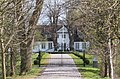
Wilhelminenhof manor house
.jpg)

In the list of cultural monuments in Kühren are the cultural monuments entered in the list of monuments of Schleswig-Holstein.
The noble estates of Kühren (with an area of 800 ha) and Wilhelminenhof have been owned by the Counts of Bülow since 1778 until today . The old manor house in Kühren was demolished in the middle of the 20th century and replaced by a new one in 1996.
Web links
Individual evidence
- ↑ North Statistics Office - Population of the municipalities in Schleswig-Holstein 4th quarter 2019 (XLSX file) (update based on the 2011 census) ( help on this ).
- ↑ Schleswig-Holstein topography. Vol. 6: Kronprinzenkoog - Mühlenrade . 1st edition Flying-Kiwi-Verl. Junge, Flensburg 2006, ISBN 978-3-926055-85-9 , pp. 50 ( dnb.de [accessed June 26, 2020]).
- ↑ Schleswig-Holstein's municipal coat of arms
- ^ Website Gut Kühren

Cities: Lütjenburg | Plön | Preetz | Schwentinental .
Other municipalities: Ascheberg (Holstein) | Barman | Barsbek | Behrensdorf (Baltic Sea) | Belau | Bendfeld | Blekendorf | Boksee | Bönebüttel | Bösdorf | Bothkamp | Brodersdorf | Dannau | Dersau | Dobersdorf | Dörnick | Driving | Fargau-Pratjau | Fiefbergen | Giekau | Grebin | Großbarkau | Grand Harrie | Heikendorf | Helmstorf | Högsdorf | Hohenfelde | Höhndorf | Hohwacht (Baltic Sea) | Honey lake | Calves | Kirchbarkau | Kirchnüchel | Klamp | Klein Barkau | Kletkamp | Köhn | Krokau | Krummbek | Cooling | Laboe | Lammershagen | Lebrade | Lehmkuhlen | Löptin | Lutterbek | Martensrade | Mönkeberg | Mucheln | Took | Nettelsee | Panker | Passade | Pohnsdorf | Post field | Prasdorf | Probsteierhagen | Rantzau | Rastorf | Rathjensdorf | Rendswühren | Angle of rest | Schellhorn | Schillsdorf | Reading | Schönberg (Holstein) | Schönkirchen | Schwartbuck | Selent | Stakendorf | Stone | Stumble | Stoltenberg | Tasdorf | Trundle | Wahlstorf | Wankendorf | Warnau | Wendtorf | Wipe | Wittmoldt .