
Kirchnüchel
| coat of arms | Germany map | |
|---|---|---|

|
Coordinates: 54 ° 12 ′ N , 10 ° 40 ′ E |
|
| Basic data | ||
| State : | Schleswig-Holstein | |
| Circle : | Plön | |
| Office : | Luetjenburg | |
| Height : | 94 m above sea level NHN | |
| Area : | 10.09 km 2 | |
| Residents: | 190 (Dec. 31, 2019) | |
| Population density : | 19 inhabitants per km 2 | |
| Postcodes : | 23714, 24327 | |
| Primaries : | 04381, 04528 | |
| License plate : | PLÖ | |
| Community key : | 01 0 57 034 | |
| Office administration address: | Neverstorfer Strasse 7 24321 Lütjenburg |
|
| Website : | ||
| Mayor : | Jörg Schöning (KWK) | |
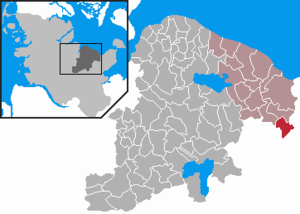
| Location of the municipality of Kirchnüchel in the Plön district | ||
  |
||

Kirchnüchel is a municipality in the Plön district in Schleswig-Holstein .
In addition to the village of Kirchnüchel, the municipality also includes the villages of Altharmhorst, Neuharmhorst and Kirchmühl.
Geography and traffic
Kirchnüchel is located southwest of the Bungsberg , at 168 meters the highest point in Schleswig-Holstein.
The Kirchnüchel community consists of the Grünhaus estate, an inn and St. Mary's Church with a rectory and cemetery.
In the St. Mary's Church, among other things, a small figure of Mary adorned with river pearls can be seen. The field stone church was an important place of pilgrimage to Mary in the pre-Reformation period . It is the highest church in Schleswig-Holstein (approx. 110 m above sea level). At the church there is a burial chapel, which was created for Cai Lorenz von Brockdorff based on the design of the Copenhagen- based Flemish sculptor Thomas Quellinus .
Kirchnüchel is on the road from Schönwalde to Lütjenburg . Not far from Kirchnüchel is the village of Nüchel with around four hundred inhabitants, which belongs to the municipality of Malente .
history
The area was inhabited from around 500 to 1100 AD by Wends who had immigrated from Mecklenburg .
The church was built in 1230.
coat of arms
Blazon : "In blue, a silver tip, like a Gothic arch, topped with a red heraldic rose with green sepals, from which three blue streams emanate fan-like and widening downwards."
Attractions
The list of cultural monuments in Kirchnüchel includes the cultural monuments entered in the list of monuments of Schleswig-Holstein.
Famous sons of the village
- the Kiel university teacher and author of a work on garden art Christian Cay Lorenz Hirschfeld (1742–1792) was born in Kirchnüchel
- the narrator and playwright Julius Stinde (1841–1905) was born in the rectory at Kirchnüchel
- Ludwig Benedict Trede (1731–1819), court official of the Principality of Lübeck in Eutin, was born on Grünhaus

Christian Cay Lorenz Hirschfeld (1742–1792)

Pastor Kirchnüchel


Web links
Individual evidence
- ↑ North Statistics Office - Population of the municipalities in Schleswig-Holstein 4th quarter 2019 (XLSX file) (update based on the 2011 census) ( help on this ).
- ↑ Schleswig-Holstein topography. Vol. 5: Holt - Krokau . 1st edition Flying-Kiwi-Verl. Junge, Flensburg 2005, ISBN 978-3-926055-79-8 , pp. 223 ( dnb.de [accessed on July 20, 2020]).
- ↑ Schleswig-Holstein's municipal coat of arms

Cities: Lütjenburg | Plön | Preetz | Schwentinental .
Other municipalities: Ascheberg (Holstein) | Barman | Barsbek | Behrensdorf (Baltic Sea) | Belau | Bendfeld | Blekendorf | Boksee | Bönebüttel | Bösdorf | Bothkamp | Brodersdorf | Dannau | Dersau | Dobersdorf | Dörnick | Driving | Fargau-Pratjau | Fiefbergen | Giekau | Grebin | Großbarkau | Grand Harrie | Heikendorf | Helmstorf | Högsdorf | Hohenfelde | Höhndorf | Hohwacht (Baltic Sea) | Honey lake | Calves | Kirchbarkau | Kirchnüchel | Klamp | Klein Barkau | Kletkamp | Köhn | Krokau | Krummbek | Cooling | Laboe | Lammershagen | Lebrade | Lehmkuhlen | Löptin | Lutterbek | Martensrade | Mönkeberg | Mucheln | Took | Nettelsee | Panker | Passade | Pohnsdorf | Post field | Prasdorf | Probsteierhagen | Rantzau | Rastorf | Rathjensdorf | Rendswühren | Angle of rest | Schellhorn | Schillsdorf | Reading | Schönberg (Holstein) | Schönkirchen | Schwartbuck | Selent | Stakendorf | Stone | Stumble | Stoltenberg | Tasdorf | Trundle | Wahlstorf | Wankendorf | Warnau | Wendtorf | Wipe | Wittmoldt .