Apatou
| Apatou | |
|---|---|

|

|
| region | French Guiana |
| Department | French Guiana |
| Arrondissement | Saint-Laurent-du-Maroni |
| Community association | Ouest guyanais |
| Coordinates | 5 ° 9 ′ N , 54 ° 21 ′ W |
| height | 0-380 m |
| surface | 2,020.00 km 2 |
| Residents | 9,241 (January 1, 2017) |
| Population density | 5 inhabitants / km 2 |
| Post Code | 97317 |
| INSEE code | 97360 |
Apatou is a French commune with 9,241 inhabitants (as of January 1, 2017) in the overseas department of French Guiana .
history
In the years 1877 to 1887, the two French researchers Jules Crevaux and Henri Coudreau demarcated the French colonial possessions from the Dutch colony of Guyana , with locals called Apatou serving as guides and porters. As a reward for their services, the locals were given the area around today's Apatou.
Apatou was created in 1976 through separation from the former large community of Grand-Santi-Papaichton-Apatou .
geography

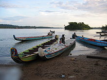
Apatou is located on the Maroni River . Since 2010 there has been a road connection between St. ´Laurent du Maroni and Apatou. Before that, Apatou could only be reached across the river. You need about 2 hours with the pirogues from Saint-Laurent-du-Maroni, which operate on the Maroni, to get there.