
Roura
| Roura | |
|---|---|
.svg)
|

|
| region | French Guiana |
| Department | French Guiana |
| Arrondissement | Cayenne |
| Community association | Center Littoral |
| Coordinates | 4 ° 44 ′ N , 52 ° 19 ′ W |
| height | 0-470 m |
| surface | 3,902.50 km 2 |
| Residents | 3,783 (January 1, 2017) |
| Population density | 1 inhabitant / km 2 |
| Post Code | 97311 |
| INSEE code | 97310 |
Roura is a French commune with 3783 inhabitants (as of January 1, 2017) in the overseas department of French Guiana , in northern South America .
geography
Roura is located in the north of French Guiana, 27 kilometers south of the capital Cayenne . In addition to the main settlement of Roura , which is located on the Oyack , the lower reaches of the Comté river, which flows into the Mahury estuary, the municipality also includes the settlement of Cacao , which is predominantly inhabited by Hmongs . In the course of colonization, these came from Laos and Indochina , a former French colony, as refugees to French Guiana.
There are numerous other small settlements on the banks of the Oyack and Mahury, including Favard , Dacca and Fourgassié .
population
The population of Roura is mixed from numerous ethnic groups who immigrated to French Guiana for various reasons. In addition to the Creoles , who make up the majority of the population, and the Hmongs in the settlement of Cacao , indigenous Palicurs and other minorities from Hawaii and Laos live in the municipality of Roura .
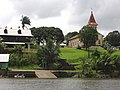
Roura on the Oyack River

... near the town center
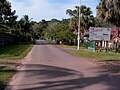
View of a typical village street near a Creole specialty restaurant

Tropical rainforest near Roura


.jpg)
