
Aurangabad (Maharashtra)
| Aurangabad | |||
|---|---|---|---|
|
|||
| State : |
|
||
| State : | Maharashtra | ||
| District : | Aurangabad | ||
| Location : | 19 ° 53 ′ N , 75 ° 21 ′ E | ||
| Height : | 585 m | ||
| Area : | 138.5 | ||
| Residents : | 1,175,116 (2011) | ||
| Website : | Aurangabad | ||
 |
|||

Aurangabad ( Marathi : औरंगाबाद , Auraṅgābād , from Persian اورنگ آباد, DMG Aurang-Ābād , ' Aurangzeb City') is a historically significant city in the western Indian state of Maharashtra with just under 1.2 million inhabitants.
location
Aurangabad is located on the Dekkan Plateau about 335 km (driving distance) east of Mumbai at an altitude of almost 600 m above sea level. d. M. The city of three million Pune is located about 240 km southwest. Aurangabad has a national airport and a train station. The climate is warm; Rain actually only falls during the summer monsoon season .
population
Official population statistics have only been kept since 1991 and are published regularly. The sustained increase in urban population is mainly due to the immigration of families from the surrounding area.
| year | 1991 | 2001 | 2011 |
| Residents | 573.272 | 873.311 | 1,175,116 |
In 1960 Aurangabad only had about 150,000 inhabitants; today there are almost 1.2 million. Of these, about 51% are Hindus , 30.5% Muslims , 15% Buddhists , 1.5% Jains and just under 1% Christians; the rest is attributable to other religions ( Sikhs , Parsees, etc.). As is common in northern India, the male population is around 9% higher than the female. Mostly Marathi , Hindi or Urdu are spoken.
economy
The city, which has grown rapidly due to the increasing narrowness of Mumbai , has been the headquarters of important companies in the automobile and two-wheeled industries (Volkswagen, Audi, Škoda Auto, MAN, Bajaj Kawasaki) and other international companies for several years; it has a university and is an important location for the Indian silk and cotton industry.
history

The city was founded around 1610 under the name Kharki (also Khadki or Khidki = "window") at the foot of the then long-abandoned Buddhist cave monastery by the Ethiopian general, politician and engineer Malik Ambar , who gave the rulers of the Deccan Sultanate of Ahmadnagar served as Prime Minister. His son Fateh Khan, who succeeded him in 1626, renamed the city Fatehnagar.
Between 1682 and his death in 1707, the city was the seat of government of the Grand Mogul Aurangzeb . The Bibi-Ka-Maqbara , a replica of the Taj Mahal , was built as a mausoleum by Azam Shah, a son of Aurangzeb, in 1697 for his mother Dilras Banu Begum and is a reminder of the glamorous era of the Mughal rule . From 1713, Asaf Jah I , who had been appointed governor of the Deccan and received the honorary title Nizam al-Mulk (Arabic: نظام الملك = "Administrator of the Empire"), resided in Aurangabad for several years. He founded a new dynasty with the capital Hyderabad founded by his son in 1763 - in the following years Aurangabad sank back to the status of a provincial town in the northwestern edge of the Marathwada region.
Alamgir Mosque (ca.1880)

Aurangzeb's Palace (ca.1830)

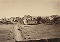
Mecca Gate (ca.1880)
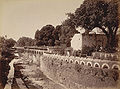
Kham River and Panchakki Bucket (ca.1880)


Attractions

The city has several well-preserved city gates on the partly well-preserved city wall. The most beautiful and largest is probably the Rangeen Gate in the northwest of the city on a traffic island that is now much bypassed. The historic city gates are not always easy to spot in the swarm of the modern, fast-growing city. Unfortunately, Aurangabad has lost some of its historical character and charm. Still, the city is more than just the starting point for tours to Ajanta or Ellora. A visit gives a good picture of a historically grown and booming Indian city in all its diversity and with strong contrasts. The existing culturally and historically significant buildings are well cared for.
- Kali Mosque (a group of seven mosques from just after 1600 and dating back to Malik Ambar)
- Bibi-Ka-Maqbara (the "Taj" of the Deccan)
- Kachner Jain Temple ( 18th century Jain temple dedicated to Tirthankara Parshvanata )
- Historic city gates (52 in total)
- Historic irrigation systems (including the Panchakki ) from the 17th century - the complex also includes a mosque and the mausoleum of Sufi saint Baba Shah Musafir .
- Chhatrapati Shivaji Maharaj Museum
- Surroundings
The Chhatrapati Shivaji Maharaj Museum is a regional history museum with handicraft, historical and archaeological objects. It is in the northwest of the city near the Rangeen Gate.
Surroundings
Aurangabad is the starting point for day trips to the surrounding cave monasteries, especially Ellora and Ajanta. Tourism plays an important role economically, with inner-Indian tourism making up a large share. Numerous travel agencies mediate drivers and automobiles.
- Aurangabad Caves (Buddhist cave monastery with 12 caves + a Brahmanic cave); approx. 3 km north of Bibi-Ka-Maqbara
- Daulatabad (fortified city founded in 1327 by Sultan Muhammad bin Tughluq as an alternative to the capital Delhi ); about 18 km northwest on the road to Ellora
- Khuldabad (numerous mausoleums of important Muslim personalities, including Malik Ambar and Aurangzeb); about 25 km northwest on the road to Ellora
- Ellora ( cave temple from the 5th – 10th centuries, including the Kailasa temple ; Buddhist, Hindu, Jainist); approx. 31 km northwest
- Ajanta (Buddhist cave monastery); about 100 km northeast
literature
- Carmel Berkson: The Caves at Aurangabad. Early Buddhist Tantric Art in India . Mapin Publ., New York / Ahmedabad 1986
Web links
- Aurangabad Municipal Corporation website
- Aurangabad tourist info (Engl.)
- Aurangabad Wikipedia
Individual evidence
- ^ Aurangabad - data 2011
- ^ Aurangabad - map with altitude information
- ↑ Aurangabad - climate tables
- ^ Aurangabad - City Population 1991-2011
- ^ Aurangabad - Census 2011
- ^ Aurangabad - Economy
Ahmednagar | Akola | Amravati | Aurangabad | Brihanmumbai | Bhiwandi-Nizampur | Chandrapur | Dhule | Jalgaon | Kalyan Dombivli | Kolhapur | Lature | Malegaon | Mira-Bhayandar | Nagpur | Nanded-Waghala | Nashik | Navi Mumbai | Parbhani | Pimpri Chinchwad | Pune | Sangli-Miraj-Kupwad | Solapur | Thane | Ulhasnagar | Vasai-Virar