Bahawalpur (District)
|
Bahawalpur District ضلع بَہاوَل پور |
|
| State : |
|
| Province : | Punjab |
| Seat : | Bahawalpur |
| Coordinates : | 28 ° 50 ′ N , 71 ° 40 ′ E |
| Area : | 24,830 km² |
| Residents : | 3,668,106 (2017) |
| Population density : | 148 inhabitants per km² |
| Time zone : | PST ( UTC + 5 ) |
| Website : | |

|
|

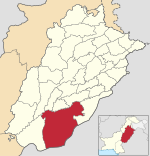
Bahawalpur District is an administrative district in Pakistan in the Punjab Province . The seat of the district administration is the city of the same name Bahawalpur .
The district has an area of 24,830 km² and according to the 2017 census 3,668,106 inhabitants. The population density is 148 inhabitants / km². The Saraiki language is spoken by the majority in the district .
geography
Bahawalpur Punjab is located in the south of the province, bordering the south and southeast by India , on the northeast by Bahawalnagar , north to Vehari , Lodhran and Multan , on the west by Rahim Yar Khan and in the northwest of Muzaffargarh . The district is the largest in Punjab and two thirds of it is desert. The district is a major cotton producer.
history
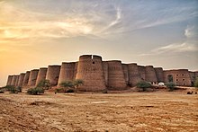
The region came under the control of the Umayyads in 711 through the conquests of Muhammad ibn al-Qasim . Later the region belonged to the Ghaznavids , the Sultanate of Delhi and the Mughal Empire , all of which left cultural influences. From 1802 Bahawalpur existed as a separate state, which however became a vassal of the British . He joined Pakistan in 1947, but the final dissolution and integration into the province of West Pakistan did not take place until 1955.
Demographics
Between 1998 and 2017, the population grew by 2.18% annually. About 32% of the population live in urban areas and about 68% in rural areas. 1,879,311 men, 1,788,578 women and 217 transgender people live in 584,864 households , which results in a gender ratio of 105.1 men per 100 women, which is the usual surplus of men in Pakistan.
The literacy rate in the years 2014/15 among the population over 10 years of age is 45% (women: 36%, men: 55%) and is thus below the Punjab province average of 63%.
| year | population |
|---|---|
| 1972 | 1,071,026 |
| 1981 | 1,453,438 |
| 1998 | 2,433,091 |
| 2017 | 3,668,106 |
Individual evidence
- ↑ a b DISTRICT WISE CENSUS RESULTS CENSUS 2017. August 29, 2017, accessed May 30, 2019 .
- ↑ Pakistani Districts wise Population Census 2017. Accessed May 30, 2019 .
- ^ Pakistan Bureau of Statistics (2016). Pakistan Social and Living Standards Measurement Survey 2014-15. Government of Pakistan, accessed June 29, 2019 .
