Helfenstein Castle (Geislingen an der Steige)
| Helfenstein Castle | ||
|---|---|---|
|
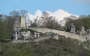
Helfenstein castle ruins - view of the complex from the south |
||
| Creation time : | around 1100 | |
| Castle type : | Höhenburg, spur location | |
| Conservation status: | ruin | |
| Standing position : | Count | |
| Construction: | Quarry stone and ashlar masonry | |
| Place: | Geislingen an der Steige | |
| Geographical location | 48 ° 36 '58 " N , 9 ° 50' 49" E | |
| Height: | 610 m above sea level NN | |
|
|
||
The Helfenstein Castle is the ruin of a 1100 built by Eberhard von Helfenstein Spur castle above the town of Geislingen in Württemberg Baden- Göppingen district .
Geographical location
The rocky 610 m above sea level. NN high mountain spur offered sufficient living space and security. In addition, the traffic through the Filstal to the Alb plateau could be controlled from there.
history
The castle was the ancestral seat of the Counts of Helfenstein , who came from the area and gained importance in connection with the Staufer emperors . After the establishment of territorial dominions, they owned a largely contiguous area around the cities of Geislingen, Heidenheim , Blaubeuren and Wiesensteig in the mid-14th century .
In 1382 the castle fell to the imperial city of Ulm as pledge , which it bought in full in 1396. In adaptation to the development of firearms, the facility was then expanded and converted into a fortress . A bulwark was built on the ridge in the direction of the hamlet , and kennel walls with rondelles were built around the old castle complex . In addition, the terrace of the "Lower Wiesle" and the rocky projection of the Ödenturm were included in the defense system. The front castle around the two rocks was the seat of the castle bailiff provided by the Ulm guilds and was expanded into a fortress against heavy artillery fire . The centerpiece was the towering “Darliß” as a turret. In the western part of the castle of Count housing (was Palas ) converted into a comfortable house for the patrician Vogt.
During the Second Margrave War , the castle fell into the hands of the Margrave of Ansbach, Albrecht Alcibiades of Brandenburg-Kulmbach, without a siege during Holy Week of 1552 . However, in August of the same year the people of Ulm succeeded in forcing the enemy crew to return the facility after several days of bombardment - mainly with heavy stone balls.
After the reconquest, the people of Ulm razed their own fortress. Forest covered the ridge until the foundation walls were exposed again from 1932 to 1938 through an excavation under the direction of local historian Georg Burkhardt . Textual records from around 1550 about the buildings and the inventory of the castle made it easier to interpret the excavated remains. Pictorial representations based on the original building or even plans from the time of its existence have not survived.
description
All in all, remains of the fortification walls and some buildings from the earlier castle are still preserved, some of which have been restored. There are cisterns in the lower and upper courtyard .
Within the mantle wall of the core fortress, a lookout point has been set up on a rock , which can be reached from the upper castle courtyard via stairs and a wooden bridge. A stone relief with the coat of arms of the Helfensteiners and a plaque commemorating the marriage of Count Ulrich V von Helfenstein to Duchess Marija Kotromanic of Bosnia, who lived at the castle from 1356 to 1396, are embedded in the wall of a former gatehouse of the main castle .
At the location of the former palace there is now a nine-meter-high rectangular observation tower with a castle tavern on the east side. From here you have a very good view of Geislingen an der Steige and the surrounding mountain ranges of the Swabian Alb .
Access to the castle
The castle is surrounded by a below hamlet on the county road K 1441 Parking located in a service road , and a newer steel bridge, which was built at the northeast corner of the castle barrier-free accessible. Further accesses are via footpaths on the west side and via the old wooden bridge on the south-east corner of the facility.
additional
From 1983 to 2012, the Helfenstein Festival, a music event (genre rock / punk) took place at the castle every year. The ruin has been an important sight on the Staufer road since 1997 .
literature
- Günter Schmitt : Castle Guide Swabian Alb, Volume 1 - Northeast Alb: Hiking and discovering between Aalen and Aichelberg . Biberacher Verlagsdruckerei, Biberach an der Riß 1988, ISBN 3-924489-39-4 , pp. 229-242.
Web links
Individual evidence
- ↑ Photo of the memorial plaque on commons.wikimedia.org
- ↑ Straße der Staufer on stauferstelen.de. Retrieved July 10, 2016.


