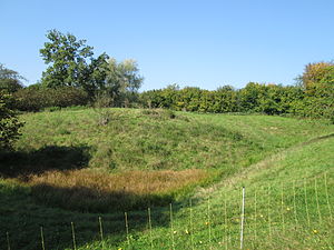
Burgstall Burren
| Burgstall Burren | ||
|---|---|---|
|
Burgstall Burren 2014, looking north |
||
| Creation time : | around 1000 to 1050 | |
| Castle type : | Niederungsburg, moth | |
| Conservation status: | Burgstall, moat, remains of foundations | |
| Place: | Wäschenbeuren - "Burren" | |
| Geographical location | 48 ° 45 '56.7 " N , 9 ° 41' 47.3" E | |
| Height: | 450 m above sea level NN | |
|
|
||
Postal Burren denotes residues of a medieval tower hill (moth) next to a water tower on the flat top of the meadow Burren about 600 meters west of the scrubber Burg in the municipality of Waeschenbeuren in district Göppingen ( Baden-Württemberg ).
During an excavation in 1957, the remains of the foundation of a square residential tower from the Romanesque period, which is believed to date from the first half of the 11th century, were found on the Burren . It was surrounded by a square ditch 60 centimeters deep and 1.5 meters wide, on the outer edge of which a wooden palisade was built. The system was only 18 meters wide from palisade to palisade. The insignificant trench, which has no defensive character, is striking. It probably only served as a fence and demarcation from the outside, including the palisade. Only the massive tower with a cross-section of 8 by 8 meters and 1.5 meters thick walls offered security against attack.
This first residential tower with an interior area of 25 square meters was replaced in the Gothic period by a new residential tower with thinner walls and a slightly larger interior area. In this context, the trench, which is still partially 3 meters deep today, was dug, the tower hill was heaped up and enlarged to an area of 18 by 18 meters, and the outer wall, which is now looped, was built.
During the excavation, the remains of a modern building were found, which the Württemberg Obervogt Sailer had built in the middle of the 18th century. Obervögte were the highest state officials at that time and had to exercise the rights of the Duke of Württemberg in their respective areas of office as supreme court, administrative and military officials . In 1861 the facility was sold for demolition. In 1961 it was owned by the Diocese of Rottenburg . Today the parcel 1600 belongs to the Catholic parish of Wäschenbeuren and is used economically to keep sheep .
It is speculated that the former ancestral castle of the Hohenstaufen can be found on the Burren . However, the archaeological findings do not provide any indication of a Hohenstaufen headquarters located there.
literature
- Günter Schmitt : Castle Guide Swabian Alb, Volume 1 - Northeast Alb: Hiking and discovering between Aalen and Aichelberg . Biberacher Verlagsdruckerei, Biberach an der Riß 1988, ISBN 3-924489-39-4 , pp. 89-94.
- Max Miller , Gerhard Taddey (ed.): Handbook of the historical sites of Germany . Volume 6: Baden-Württemberg (= Kröner's pocket edition . Volume 276). 2nd, improved and enlarged edition. Kröner, Stuttgart 1980, ISBN 3-520-27602-X .
Individual evidence
- ^ Entry on Burgrest Burren in the private database "Alle Burgen".
- ↑ a b c Peter Koblank: Burgstall "Burren" near Wäschenbeuren . on stauferstelen.net. Retrieved January 12, 2015.
- ^ A b c d Hartwig Zürn: excavations on the "Burren" near Wäschenbeuren (Kr. Göppingen) . In: Württembergischer Geschichts- und Altertumsverein (Hrsg.): Find reports from Schwaben , New Series 15, Stuttgart 1959, pp. 110–115 .
- ↑ Hartwig Zürn: The prehistoric and early historical site monuments and the medieval castle sites in the districts of Göppingen and Ulm. Stuttgart 1961, p. 13 .
- ^ Historical plaque requested from the Burren. (No longer available online.) Swp.de, June 18, 2010, formerly in the original ; Retrieved December 29, 2012 . ( Page no longer available , search in web archives ) Info: The link was automatically marked as defective. Please check the link according to the instructions and then remove this notice.
- ↑ Hans-Martin Maurer: The Hohenstaufen. History of the ancestral seat of an imperial family . Stuttgart / Aalen 1977, p. 18.


