
Burgstall Old Castle (Affalterthal)
| Burgstall Old Castle | ||
|---|---|---|
02.JPG) Image 1: View of the Burgstall from the east (November 2013) |
||
| Creation time : | Probably from the Middle Ages | |
| Castle type : | Höhenburg in spur location | |
| Conservation status: | Burgstall | |
| Standing position : | Unknown | |
| Construction: | Ashlar masonry | |
| Place: | Egloffstein - Affalterthal - "Altschlossberg" | |
| Geographical location | 49 ° 42 '39.3 " N , 11 ° 16' 0.5" E | |
| Height: | 458.9 m above sea level NN | |
|
||

The Postal Old Castle is an Outbound probably late medieval nobility castle near the village Affalterthal , a district of Egloffstein in the Upper Franconian district of Forchheim in Bavaria ( Germany ).
The castle stable of the Spornburg is freely accessible.
Geographical location
The small former hill fort is located in the Franconian Switzerland-Veldenstein Forest Nature Park , about 850 meters west-northwest of the church in Affalterthal at 458.9 m above sea level. NN on the summit of the Altschlossberg , about 15 kilometers east of Forchheim .
The castle Egloffstein , the castle ruins Thuisbrunn and the castle stables are very close . To the north-west of Oberzaunsbach there is another castle stable called the Old Castle . To the north of the village of Äpfelbach are the remains of a large prehistoric and early historical fortification on Heidelberg.
History of the castle
Nothing is known of the history of the small castle, according to the Nuremberg castle researcher Hellmut Kunstmann, the Lords of Egloffstein could be considered as builders . Otto von Affaltert, who was mentioned in 1133, could also have sat in the castle. However, he stands as a witness in a document between the Upper Palatinate ministerials , so that he, too, may come from the Upper Palatinate area and is therefore out of the question as lord of the castle.
In 1610, during the settlement of a border dispute over a forest in the Wolfsreuth corridor, a German castle was mentioned, which was probably the old castle near Affalterthal.
The ground monument recorded by the Bavarian State Office for the Preservation of Monuments as a "presumably prehistoric hilltop settlement and medieval castle stables Old Castle" bears monument number D-4-6233-0081.
description
The former castle was on a rocky knoll, the highest point of a mountain spur (Fig. 3), which extends to the northwest. On the north-west and north-east side, the valley of the Brunnengraben borders the mountain spur, where the castle was naturally well protected by the steep slope of the mountainside. On the southwest side, the spur is bounded by the Heugraben Valley, where the slope only falls moderately steeply and in steps into the valley, so that an enemy attack was quite possible from this side. To the east, the area of the castle drops steeply about eight meters (Fig. 1, 5 and 8), there a six to eight meter wide ditch with a rampart in front (Fig. 4 and 5) was created, which separates the east side of the castle from the adjoining area separated.
The base of the castle is roughly triangular and has an area of around 35 by 25 meters (Fig. 2). Only a few traces of the former buildings have survived on the castle plateau. On the northeast side there are two stone walls that run parallel to the edge of the plateau and are separated from one another by a section ditch about two meters wide and one meter deep. The longer outer wall is ten meters long, the inner one about eight meters. In the west, next to the stone walls, there is a round, two-meter-deep hollow (Fig. 6), which presumably comes from the cellar of a castle building, immediately next to it is a right-angled remains of the foundation wall about 3 and 1.8 meters long, consisting of cuboid stones (Fig. 6 and 7). On the south side, another roughly 1.5 meter deep rectangular hollow can be seen. It is bordered on three sides by walls with residues of mortar, so that perhaps a tower-like building stood there (Fig. 2).
The castle path probably led below the tower-like building on the southern slope along an old cart, then turned north at the southwest end of the castle plateau and reached the entrance to the castle.
photos
15.jpg)
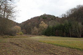
Image 3: View of the Altschlossberg from the west from the Brunnengrabental (November 2013)

Figure 4: Most clearly profiled point of the trench and the rampart in the northeast (November 2013)
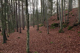
Photo 5: Looking back to the south, on the right the climb to the castle site (November 2013)

Image 6: Probable cellar pit of a building in the castle, left of the L-shaped foundation wall to the right of the image (November 2013)

Photo 7: L-shaped foundation wall remnants (November 2013)

Image 8: View from the castle site over the moat and wall to the east (November 2013)

Photo 9: View to the west to the Spornspitze, the building boundary in this direction is not entirely clear due to recent disturbances (November 2013)
10.JPG)
04.JPG)
06.JPG)
09.JPG)
20.JPG)
18.JPG)
19.JPG)
literature
- Walter Heinz: Former aristocratic residences in the Trubach Valley: a guide for friends of home and hikers . Palm and Enke Verlag, Erlangen and Jena 1996, ISBN 3-7896-0554-9 , pp. 181-185.
- Hellmut Kunstmann : The castles of south-western Franconian Switzerland . 2nd Edition. Commission publisher Degener & Co., Neustadt an der Aisch 1990, pp. 238-239.
- Klaus Schwarz: The prehistoric and early historical monuments in Upper Franconia . (Material booklets on Bavarian prehistory, series B, volume 5). Verlag Michael Lassleben, Kallmünz 1955, p. 88.
Web links
Individual evidence
- ^ Topographic map 1: 25000, sheet 6233 Ebermannstadt
- ^ Location of the Burgstall in the Bavaria Atlas
- ^ Walter Heinz: Former noble residences in the Trubachtal: A guide for friends of home and hikers , p. 191
- ↑ Guide to Archaeological Monuments in Germany, Volume 20: Franconian Switzerland, p. 157
- ↑ Hellmut Kunstmann: The castles of southwestern Franconian Switzerland , p. 238 ff.
- ↑ Burgstall Altes Schloss on the website of the Bavarian State Office for Monument Preservation ( Memento of the original from November 17, 2016 in the Internet Archive ) Info: The archive link has been inserted automatically and has not yet been checked. Please check the original and archive link according to the instructions and then remove this notice.


Castles: Ermreuth Castle | Graefenberg Castle (stone house, large house, Nuremberg nursing home) | Guttenburg Castle | Hagenbach Castle | Hallerndorf Castle (exited) | Heroldsbach Castle | New Castle (Hiltpoltstein) | Hundshaupten Castle | Jägersburg Castle | Kunreuth Castle | Pretzfeld Castle | Schellenberg Castle (exited) | Thurn Castle | Unterleinleiter Castle | Wiesenthau Castle | Wolfsberg Castle (Graefenberg) | Wüstenstein castle ruins
Castles and ruins: Bärnfels castle ruins | Bieberbach Castle (exited) | Dietrichstein Castle (exited) | Dietzhof Castle (exited) | Dörnhof Castle (exited) | Egloffstein Castle | Forchheim Castle | Gaillreuth Castle | Gößweinstein Castle | Graefenberg Castle (exited) | Hiltpoltstein Castle (Old Castle) | Kohlstein Castle | Moschendorf Castle (exited) | Neideck Castle ruins | Niederfellendorf Castle (exited) | Obertrubach Castle (exited) | Oberweilersbach Castle (exited) | Regensberg castle ruins | Reifenberg Castle (exited) | Reuth Castle (exited) | Rothenbühl Castle (exited) | Keystone Castle (exited) | Streitburg castle ruins | Thuisbrunn castle ruins | Unterleinleiter Castle | Vestenberg Castle (exited) | Wichsenstein Castle (exited) | Wolfsberg castle ruins | Wolkenstein castle ruins
Fortifications: Forchheim Fortress
Tower hill castles (all gone): Turmhügel Burk | Burgstall Ebermannstadt | Kersbach Tower Hill | Niedermirsberg tower hill | Tower Hill Rüssenbach | Tower hill Wöhr
Manor houses: Manor Dormitz (sold) | Steinhaus mansion (Dormitz) (sold) | Hammermühle Manor (sold) | Walkersbrunn manor (sold) | Wannbach manor
Castle stables (lost, unknown castles): Section fortification Altenburg | Section fortification Burggraf | Burgstall Alter Schlossberg | Burgstall Old Castle (Affalterthal) | Burgstall Old Castle (Oberzaunsbach) | Ringwall Old Castle (Drgendorf) | Section fortification Borschl | Burgstall Breitensten | Section fortification Burggraf | Burgstein Castle Stable (Peoplebach Castle?) | Ringwall Ehrenbürg | Burgstall Hainburg (Burgstall Rüsselbach, Burgstall on the cat) | Ringwall Heidelberg | Burgstall Heiliger Bühl | Burgstall Hetzelsdorf | Section fortification Hunnenburg | Section fortification Lehmberg | Burgstall Leutenbach | Ringwall Lindelberg | Burgstall Lindelburg | Section fortification Reisberg | Burgstall Retterner Pulpit | Burgstall Sattelmannsburg (Stadtmers Bürg) | Ringwall Schießberg | Burgstall Schlossberg (Haidhof) (Heidenstein) | Burgstall Thüngfelderstein (Eberhardstein Castle) | Section fortification Deep Storm | Burgstall Unterailsfeld | Burgstall Wartleiten
Fortified churches: Fortified Church Burk (Holy Three Kings) | Fortified Church Dormitz (Our Dear Lady) | Fortified church Ebermannstadt (St. Nikolaus) | Fortified church Effeltrich (St. Georg) | Fortified church Eggolsheim (St. Martin) | Kersbach fortified church (St. Johannes Baptist and St. Ottilie) | Fortified church Kirchrüsselbach (St. Jakobus) | Fortified church Langensendelbach (St. Peter and Paul) | Pautzfeld fortified church (Assumption of Mary) | Fortified church Pinzberg (St. Nikolaus) | Willersdorf fortified church (St. Bartholomäus)