
Eselsburg Castle
| Eselsburg Castle | ||
|---|---|---|
 The castle rock above the Eselsburger valley |
||
| Creation time : | around 1200 | |
| Castle type : | Höhenburg, spur location | |
| Conservation status: | Burgstall, traces of terrain, moat, remains of walls | |
| Standing position : | Ministeriale | |
| Construction: | Small cuboid, humpback cuboid, quarry stone masonry | |
| Place: | Herbrechtingen- Eselsburg | |
| Geographical location | 48 ° 36 '2 " N , 10 ° 10' 58" E | |
| Height: | 521 m above sea level NN | |
|
||

The castle Eselsburg above the Herbrechtsmeier Inger district Eselsburg in the district of Heidenheim in Baden-Wuerttemberg .
Geographical location
The abandoned Spornburg is about 50 meters above the valley floor of the Eselsburger valley and the village of the same name. The core castle lay on the castle rock (521 meters above sea level ) - protruding from the edge of the valley - and is cut off from the hinterland by an arched neck ditch .
history

The Eselsburg was built around 1200 as the seat of a ministerial family of the Counts of Dillingen . An older castle square may have been reused for this purpose. In 1244 a Gerwig (Gerwicus) von Eselsburg appears in a document. A Rudolf von Eselsburg served Count Ulrich II von Helfenstein in 1270 . In 1284 another Gerwig appeared as a servant of the Bishop of Augsburg . In 1343 the Eselsburgers sold their castle and their goods in Herbrechtingen.
In 1385 Wilhelm von Riedheim came into possession of the facility. In 1414 Heinrich von Bopfingen acquired the rule, which became an imperial fief in 1441. In 1444 Rudolf von Bopfingen sold his half of the castle to Heinrich Krafft from Ulm , who a year later also acquired the other half from Sigmund von Eselsburg. In 1453 the emperor released the fortress from its feudal sovereignty.
In 1462 the castle was burned down in the Imperial War against the Duchy of Bavaria and came to Eitelhans von Knöringen around 1479 . In 1503 the gentlemen from Eben sat on the donkey castle. Christoph Friedrich von Eben finally sold the property to his brother-in-law Ulrich von Rechberg zu Falkenstein in 1562 . After the resale to Württemberg , the residence was cleared from 1593 and began to fall apart. As early as 1690 the castle was "gone and completely collapsed".
description
From the high medieval ministerial castle only the neck ditch , traces of the terrain and small remains of the wall have survived.
The trench was dug out of the rock and is about five meters deep and four to five meters wide. In addition, a triangular outer bailey protected the fortress. The angular moat can still be largely traced in the terrain, but the southern section has been filled.
The small remnants of the rectangular core castle (approx. 23 by 30 meters) consist of high medieval cuboids and rubble stones . According to the "Renlin Forest Map" ( Germanisches Nationalmuseum Nürnberg ) from 1591, there were two castle houses with gable roofs and a tower crowned by a helmet. The small courtyard was located between the two wings to the west and east. A wall remnant in front of the east building could belong to a kennel wall , between this wall and the neck ditch runs a shallow hollow.

Burgstall from the east
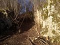
Neck ditch

Wall remains
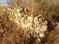
Wall remains


Web links
literature
- Günter Schmitt : Castle Guide Swabian Alb. Volume 6 - Ostalb: hiking and discovering between Ulm, Aalen and Donauwörth . Biberacher Verlagsdruckerei, Biberach an der Riß 1995, ISBN 3-924489-74-2 , pp. 325-330.


Castles: Ballmertshofen Castle | Bergenweiler moated castle | Brenz Castle | Burgberg Castle | Duttenstein Castle | Eglingen Castle | Hellenstein Castle | Niederstotzingen Castle | Oberstotzingen Castle | Lower Oggenhausen Castle | Upper Oggenhausen Castle | Schnaitheim Hunting Lodge | Stetten ob Lontal Castle | Castle taxis
Castles and ruins: Auernheim Castle | Aufhausen Castle | Benzenberg Castle | Bindstein Castle | Dunstelkingen Castle | Eselsburg castle ruins | Falkenstein Castle | Castle ruins Güssenburg | Herwartstein Castle | Hürben Castle | Hürgerstein Castle | Hurwang castle ruins | Castle ruin Kaltenburg | Katzenstein Castle | Knollenburg Castle | Ravensburg castle ruins
Castle stables (lost, unknown castles): Old Castle (Demmingen) | Burgstall Burstel | Burgstall im Hartwald | Michelstein Castle | Schlössle