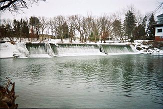
Cedar River (Iowa River)
| Cedar River | ||
|
Cedar River (north) and Iowa River (south) |
||
| Data | ||
| Water code | US : 465058 | |
| location | Minnesota , Iowa (USA) | |
| River system | Mississippi River | |
| Drain over | Iowa River → Mississippi River → Gulf of Mexico | |
| source | north of Sargeant 43 ° 50 ′ 5 ″ N , 92 ° 48 ′ 28 ″ W |
|
| muzzle | in Columbus Junction Coordinates: 41 ° 16 '59 " N , 91 ° 20' 49" W 41 ° 16 '59 " N , 91 ° 20' 49" W. |
|
| Mouth height |
174 m
|
|
| length | 544 km | |
| Big cities | Cedar Rapids | |
| Medium-sized cities | Austin , Cedar Falls , Waterloo | |
|
Cedar River near Austin, Minnesota |
||
The Cedar River ( English for " cedar -flow") is a 544 km long left tributary of the Iowa River in the US -amerikanischen states Minnesota and Iowa .
geography
The river has its source north of Sargeant in Dodge County , Minnesota and flows through Mower County before crossing the northern Iowa border.
In the further southeast of the Cedar River flows through the Mitchell , Floyd , Chickasaw and Bremer Counties , before reaching the nearby cities of Cedar Falls and Waterloo in Black Hawk County . After that, the flowing through Benton County and reaches in Linn County to Cedar Rapids , the largest city on its banks.
Then the Cedar River flows through the Johnson , Cedar and Muscatine Counties before flowing into the shorter Iowa River in Louisa County in the city of Columbus Junction . This flows about 40 km further southeast into the Mississippi , which forms the border with Illinois .
Individual evidence
- ↑ Cedar River in the United States Geological Survey's Geographic Names Information System.Retrieved April 2, 2012
- ↑ USGS The National Map Viewer , accessed April 2, 2012
- ↑ Distance information according to Google Maps. Retrieved April 2, 2012

