
Crohn's Kraton
The Crohn craton is an East Antarctic craton that is largely hidden under the Antarctic ice sheet . Only minor outcrops are found in Queen Marie Land and in the southernmost areas of the southern Prince Charles Mountains . Its earliest protoliths (parent rocks) crystallized out around 3390 mya . It is believed that the craton is defined in the east by the geosuture of the Antarctic branch of the Pinjarra orogeny and in the west by the course of a late Mesozoic passive continental margin identified in the Shackleton Range and the Prince Charles Mountains.

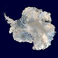
Geographic map of Antarctica
Satellite image of the Antarctic ice sheet without the ice shelf

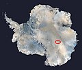
Reconstruction of the Mawson Craton with the adjacent Crohn Craton


Naming
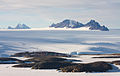
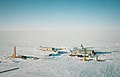
Mawson Station with a view of the David Range

This kraton was named in honor of Peter Crohn . He was a geologist and a member of the 1954 Australian Expedition that founded the Australian Mawson Station . He was also one of the expedition members who first visited the Prince Charles Mountains in the winter of 1954. This area is one of the main areas where Crohn's craton rocks have been exposed.
Geological framework
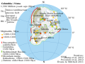
Hypothetical paleogeography of Columbia

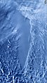
MODIS satellite image of the Bunger Hills


Since the formation of the supercontinent of Columbia , the former southern area of Australia (Northern Australia) and East Antarctica have been tectonically connected from about 2000 mya . From 1730 mya the Nimrod and Kimban orogeny led to the formation of the Mawson craton on what was then the eastern edge of East Antarctica. The western edge of the Mawson carton developed during the Kararan orogeny from 1570 mya. A rotation of northern Australia or the Yilgarn craton led between 1350 and 1140 mya to the formation of the Albany-Fraser orogen between the two continental plates. Along the Darling Fault ( warp ) opened a grave fraction or a basin between the Yilgarn Kraton and East Antarctica. The Darling Fault ran on the western edge of the Yilgarn Craton and continued further south between the East Antarctic Bunger Hills and the Scott Glacier on the one hand and the Denman Glacier on the other. It separated the Obruchev Hills from the Bunger Hills. It also separated western parts of the Albany-Fraser orogen and the Coompana block, the sizes of which are unknown. The Coompana block formed the western edge of the Mawson kraton (see also → Mawson kraton ).
With the closure of the rift valley, the Pinjarra ore formed between 1080 to 1060 mya. This period corresponds to a cycle of Grenville orogeny , which led to the formation of the supercontinent Rodinias . It divides East Gondwana into Australian-Antarctic and Indo-Antarctic areas. The course of the Pinjarra orogen under the East Antarctic ice sheet is unknown or controversial. Presumably, however, it is of similar latitude and longitude to the East African Orogen and must have been a fundamental neoproterozoic border that was of crucial importance for the formation and dissolution of the supercontinent of Gondwana .
The East Antarctic rocks west of the Pinjarra orogen show an affinity for occurrences in South Australia, while on the eastern side they show no clear relationship with the current closest neighbors in Antarctica. They are assigned to the Crohn Kraton.
Occurrences and rocks
Most of the Crohn's craton is currently hidden under the Antarctic ice sheet . Hence, its size, shape and geology are largely unknown. It is believed that the craton is bounded in the east by the geosutur of the Antarctic branch of the Pinjarra orogen. Its rocks were subjected to a high-grade metamorphosis from 1080 mya with the formation of granulite facies . This period falls in the development phase of the supercontinent Rodinia. To the west, the course of a late Mesozoic passive passive continental margin is believed to be identified in the Shackleton Range and the Prince Charles Mountains. The Crohn's craton probably occupies about a third of the subglacial area of East Antarctica.
The main outcrop areas of the Crohn Craton consist of the limited occurrences west of the Scott Glacier in Queen Marie Land and the southernmost outcrops in the southern Prince Charles Mountains. The outcrops of the Scott Glacier consist of two temporally separated occurrences of archaic orthogneiss . The older one dates to 3005 mya and was metamorphically overprinted around 2890 mya . This rock remodeling occurred before the formation of the younger suite, which is around 2640 mya old. In the southern Prince Charles Mountains, the Crohn Craton is defined both by the deformed archaic basement complex of the Ruker Province and by a number of more recent discordant (irregular) cover layer sequences.

Map of the Prince Charles Mountains with the Lambert Glacier and Amery Ice Shelf

The development of the crystallized Ruker Province can be traced back to approx. 3900 mya. The earliest protoliths (parent rocks) crystallized out around 3390 mya. The granitic- orthogneissic basement of the southern Prince Charles Mountains formed from them, overlaid by a mighty sequence of metasediments .
The mountains and rock formations of the Ruker Province protruding from the ice cover form the southern Prince Charles Mountains. They connect to the southern areas of the northern Prince Charles Mountains with the Rayner Province . In the direction of the continental margin extending Lambert trench divides the Ruker province in two Terranes that Ruker-Terran and Lampert-Terran. You are in Mac Robertson Land , the Lambert Terran can also be assigned to Princess Elisabeth Land . The latter adjoins the Ruker Terran to the northeast.
The Obruchev Hills , which were separated from the Bunger Hills by the Darling Fault, consist, like Bunger Hills, predominantly of Felsic orthogneiss with an overprinting metamorphic to granulite facies and subordinate mafic granulites and paragneiss . They also show clear geochronological similarities with the Albany-Fraser Orogen.
Geomorphological features
The remarkable geomorphological objects of the Gamburzew Mountains and Lake Vostok are located in the Crohn Craton .

Topographic map of Antarctica after removal of the ice cover, its isostatic effect and sea rise

- The Gamburzew Mountains are completely hidden under the ice sheet and encompass around 300,000 km², a mountain range of around 1200 kilometers in length with the highest elevations of around 3000 meters. It lies under the East Antarctic plateau near its highest point, Dome A in the middle of East Antarctica. Since the thick ice cover that formed around 35 mya ago does not allow for direct sampling, various remote sensing methods were carried out using aircraft . A strongly jagged mountain range was discovered, which was presumably formed as a result of the collision of two lithospheric plates . This could have occurred either during the Pinjarra orogeny or in the context of the formation of Rodinia from approx. 1000 mya. Any other subsequent erosion postulated and the various tectono-thermal processes assumed from approx. 250 mya were not confirmed with these measurements.
Position of Lake Vostok

Map section with subglacial Lake Vostok
Radar image ( RADARSAT-1 ) of Lake Vostok from space. The ice over the lake has a smooth surface
Russian Vostok Station


- The Vostok Sea is the largest subglacial Antarctic freshwater lake . It lies at a depth of up to 4,100 meters under the ice and extends from the Russian Vostok station almost 250 kilometers to the north. The cold pole of the earth is at the Vostok station . The lowest temperature during the Antarctic polar night was minus 89.2 ° C. The lake is 50 kilometers wide and the water depth is up to 1200 meters. The lake has formed in the tectonic Vostok Basin in the entire area surrounding a continental collision zone several hundred kilometers wide between the Gamburtsev Mountains and the Dome Charlie region. It is estimated that the lake water was sealed by the ice sheet about 15 mya ago. It is subject to tidal fluctuations of up to 2 centimeters. Despite the extreme habitat , the lake seems to be home to an amazing biodiversity of micro and small organisms .
Web links
- Georg Kleinschmidt: Geological development and tectonic structure of the Antarctic. In: Warning signal climate: The polar regions. Scientific evaluations, Hamburg. 376 pages. PDF
- EV Mikhalsky: The Tectogenesis Stages of the Antarctic Shield: Review of Geochronological Data. In: Moscow University Geology Bulletin, 2007, Vol. 62, No. 3, pp. 143-154. doi: 10.3103 / S0145875207030027 , PDF
- Simon L. Harley, Ian CW Fitzsimons and Yue Zhao: Antarctica and supercontinent evolution: historical perspectives, recent advances and unresolved issues. In: Geological Society, London, Special Publications, 383, 1-34, 9 October 2013. doi: 10.1144 / SP383.9 , alternative
- Vanessa Markwitz; Christopher L. Kirkland; Noreen J. Evans: Early Cambrian metamorphic zircon in the northern Pinjarra Orogen: Implications for the structure of the West Australian Craton margin. In: Lithosphere (2017) 9 (1): 3–13. doi: 10.1130 / L569.1 , alternative
Individual evidence
- ^ MH Monroe: Antarctica - Before and After Gondwana. In: Gondwana Research, Volume 19, Issue 2, March 2011, Pages 335-371. doi: 10.1016 / j.gr.2010.09.003 , alternatively
- ^ Nick MW Roberts: The boring billion? - Lid tectonics, continental growth and environmental change associated with the Columbia supercontinent. In: Geoscience Frontiers, Volume 4, Issue 6, November 2013, Pages 681-691. doi: 10.1016 / j.gsf.2013.05.004 , alternatively
- ^ She Fa Chen, Angela Riganti, Stephen Wyche, John E. Greenfield and David R. Nelson: Lithostratigraphy and tectonic evolution of contrasting greenstone successions in the central Yilgarn Craton, Western Australia. In: Precambrian Research, Volume 127, Issues 1-3, November 10, 2003, Pages 249-266. doi: 10.1016 / S0301-9268 (03) 00190-6 , alternatively
- ^ Daniel James Clark: Thermo-Tectonic Evolution of the Albany-Fraser Orogen, Western Australia. In: Thesis submitted for the degree of Doctor of Philosophy, University of New South Wales. Download PDF
- ^ Tom Wise, Rian Dutch, Mark Pawley, Clive Foss and Stephan Thiel: Building the Coompana Province. In: MESA Journal 88, pages 25–37, Published December 2018. Online article
- ^ SA Wilde: Evolution of the Western Margin of Australia during the Rodinian and Gondwanan Supercontinent Cycles. In: Gondwana Research, Volume 2, Issue 3, July 1999, Pages 481-499. doi: 10.1016 / S1342-937X (05) 70287-2 , alternative
- ^ ICW Fitzsimons: Proterozoic basement provinces of southern and southwestern Australia, and their correlation with Antarctica. In: Geological Society, London, Special Publications, 206, 93-130, 1 January 2003. doi: 10.1144 / GSL.SP.2003.206.01.07 , alternative
- ↑ NL Alexeev, TF Zinger and IN Kapitonov: Age of Charnokitic Magmatism from the Obruchev Hills, Banger Denman- Area (East Antarktica). In: Doklady Earth Sciences, Volume 440, Issue 1, pp.1233-1238. doi: 10.1134 / S1028334X1109025X , alternatively
- ↑ Andrew J. Lloyd, Andrew A. Nyblade, Douglas A. Wiens, Samantha E. Hansen and others: Seismic structure of the upper mantle under the central East Antarctic from body wave tomography : Implications for the formation of the Gamburtsev subglacial mountains. In: Geochemistry, Geophysics, Geosystems, Volume 14, Edition 4, Pages: 759-1320, April 2013. doi: 10.1002 / ggge.20098 , alternative