Shackleton Range
| Shackleton Range | ||
|---|---|---|
| Highest peak | Holmes Summit ( 1875 m ) | |
| location | East Antarctica | |
|
|
||
| Coordinates | 80 ° 30 ′ S , 26 ° 0 ′ W | |
| surface | 14,000 km² | |
|
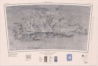
1983 Shackleton Range map |
||
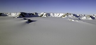
The Shackleton Range is a partially ice-free mountain range in Antarctica , which extends 240 km in an east-west direction and has an area of approximately 14,000 km². The main peaks reach heights of 1400 to 1600 m; the highest height is the Holmes Summit with 1875 m. The mountain range was named after the British polar explorer Ernest Shackleton .
Discovery story
The Shackleton Range was first sighted from an Argentine aircraft in December 1955. Further sightings took place during the Commonwealth Trans-Antarctic Expedition (1955-1958) by British aircraft. In October 1957, two surveyors and a geologist from a British expedition set foot on the mountains for the first time . In addition to the topographical survey, geological samples were collected. In the southern summers between November 1968 and February 1971, the surveying work was continued and the geology of the mountain was explored in its main features. Detailed geological research in individual parts of the mountain was carried out in the southern summers of 1975/76 to 1982/83 by Soviet expeditions, the results of which, however, were only scientifically evaluated and published up to the 1977/78 expedition. Two expeditions were subsequently organized by the Federal Institute for Geosciences and Raw Materials , the so-called GEISHA expedition 1987/88 and the EUROSHACK expedition 1994/95. The focus of these expeditions was on geological and geophysical work programs.
geography
The Shackleton Range extends over a distance of approximately 240 km from the southeastern end of the Filchner-Ronne Ice Shelf in an easterly direction with a maximum north-south extension of 70 km. The mountain range is bounded in the north by the Slessor Glacier and in the south by the Recovery Glacier . The ice-free Nunatakker and mountain ranges rise from 400 m at the western edge of the mountain to over 1800 m at the eastern end.
The ice-free areas are divided into six parts by smaller glaciers and extensive snow fields:
- in the far west the Otter Highlands , on the eastern edge of which the Blaiklock Glacier flows north;
- then the Haskard Highlands , which are bounded in the east by the Stratton Glacier ;
- the La Grange Nunatakker , which are spread over an area of more than 1,600 km² in the north of the mountains between the Stratton and Gordon glaciers ;
- the Herbert Mountains in the north central part of the Shackleton Range;
- the Pioneers Escarpment to the northeast;
- and in the south of the mountains the Read Mountains with the Stephenson Bastion slightly to the west .
The central area of the Shackleton Range forms an old peneplain , which is almost completely covered by snow fields. In the northwestern part of the Shackleton Range there are two small, permanently ice-covered lakes, the Nostoc Lake at the foot of Mount Provender in the Haskard Highlands and the Folkertssee in the northwestern La Grange-Nunatakkern.
The Shackleton Range is not a " meteorite trap " like other regions of Antarctica. The only documented find so far is a 3.5 kg nickel-iron meteorite that was discovered by the GEISHA expedition.
geology
To the south of the Shackleton Range, the edge of the Precambrian Antarctic Shield is exposed. There in the Read Mountains, Middle Proterozoic gneisses form the basement , on which remains of a Lower Cambrian , slightly metamorphic overburden are preserved. At the end of the Cambrian, about 500 million years ago, the Antarctic continent collided with another continent (probably part of southern Africa), fragments of which are now preserved in the northern Shackleton Range. During this collision, rocks from this continent were pushed as a tectonic blanket to the south on the Read Mountains. Erosion began as early as the Ordovician , as a result of which the ancient rocks of the Antarctic continent in the center of the Read Mountains were exposed as a geological window and the rubble was deposited in the northwest of the mountains. The Otter Highlands, in particular, are made up of green sandstones , conglomerates and siltstones , the latter of which contain trace fossils that have an Ordovician age.
At the end of the Carboniferous the Shackleton Range was covered by glaciers for the first time. When they retreated in the Permian , debris was deposited, the remains of which are preserved in some places in the easternmost part of the mountains and form the youngest known rocks of the Shackleton Range.
literature
Clarkson, PD, Tessensohn, F., Thomson, JW et al. (1995) Geological map of Shackleton Range, Antarctica . BAS GEOMAP Series, Sheet 4, 1: 250,000, with supplementary text. 79 pp., Cambridge. ISSN 0951-8886
Web links
- Skidmore, MJ & Clarkson, PD: Physiography and Glacial Geomorphology of the Shackleton Range . 1972. Archived from the original on May 17, 2013. (PDF file; 5.25 MB)
- Satellite map of the Shackleton Range accessed on May 23, 2017 (PDF file; 2.2 MB)
Individual evidence
- ↑ Holmes Summit on Peakbagger.com (English)
- ↑ BGR logo of the GEISHA expedition accessed on July 22, 2009
- ↑ BGR logo of the EUROSHACK expedition accessed on July 22, 2009
- ↑ Page of the Federal Institute for Geosciences and Raw Materials on the Mount Wegener Meteorite accessed on July 22, 2009
- ↑ Georg Kleinschmidt & Werner Buggisch (1993): Plate tectonic implications of the structure of the Shackleton Range, Antarctica. Polarforschung 63 , pp. 57-62 (PDF; 610 kB) accessed on July 22, 2009
- ↑ Franz Tessensohn, Georg Kleinschmidt , Werner Buggisch (1999): Permo-Carboniferous glacial beds in the Shackleton Range. Terra Antartica 6 , pp. 337-344


