
Dinogetia
| Dinogetia Castle | |
|---|---|
| Alternative name | Dinogetia |
| limes | Middle and late Roman Mösischer Limes |
| Dating (occupancy) | a) Middle Imperial (?) b) Late 3rd century (?) to early 7th century; c) after 971 to the end of the 12th and beginning of the 13th century |
| Type | late antique fortress |
| size | approx. 0.78 ha |
| Construction | Stone fort |
| State of preservation | preserved remains visible in the area |
| place | Garvan |
| Geographical location | 45 ° 22 '45 " N , 28 ° 8' 19.3" E |
| Subsequently | Novidunum Fort (southeast) |


Dinogetia is a former late Roman military camp which, as a border fortification, was responsible for guarding a section of the Mösian Limes on the lower course of the Danube . The place also became known as an important ancient and medieval civil town.
It is very likely that the fort has existed since the middle of the Imperial period. The remains of the undeveloped facility, which have been made visible since 1939, are located five kilometers northwest of the Romanian village Garvan in the Tulcea district in Dobruja , around ten kilometers southeast of the city of Galatz . The fortress belonged to the kingdom division 395 n. Chr. For Byzantine territory and remained until the Awareneinfällen occupied by 596/597. After the Byzantine recapture of large parts of Moesia, Thrace and Scythia in the early Middle Ages, the complex was revived and incorporated into a settlement for around 200 years.
location
Dinogetia was in the area of the Roman province of Moesia inferior (Lower Moesia ), from which the Moesia secunda (Upper Moesia ) emerged in late antiquity and belonged to the diocese of Thrace. After the Byzantine renewal of the empire from AD 971, the theme of Paristrion emerged in the area of the former province .
The facility was built on a slightly elevated, rocky headland within a Danube Bend extending from south-west to south-east. The rock spur, which is up to ten kilometers away from the south bank of the Danube and is formed in a north-westerly direction, offered a location well protected from floods in the surrounding area that has remained marshy to the present day. From the fort square there is a good view of the open, mainly agricultural land. This is limited only in the west by the northernmost foothills of the Măcin Mountains, which spread out as an elongated, finger-shaped chain of hills in a north-westerly direction from the main massif. Only a few kilometers north of the fortification, however, the traces of this altitude structure are lost again. With its twelve defense towers and the gate system, the late antique Dinogetia formed a landmark that could be seen from afar.
Research history
As early as the middle of the 19th century, the remains of the fort square that were visible at that time were documented in drawings. In 1939 Gheorghe Ștefan (1899–1980) began digging, but was only able to resume it in 1949 after the Second World War. He was later followed by Ion Barnea , who has continued the research since that time. Larger investigations took place in the years 1976 to 1981 and 1983. Even today Dinogetia is an archaeological site. The visible remains of the fortress were conserved, restored and partially reconstructed for visitors after the archaeological findings.
Building history
Roman Imperial Era
Numerous brick stamps, pottery shards and coins from the 1st to 3rd centuries suggest an imperial garrison location, but this has not yet been proven.
The existence of the place in the 2nd century is also confirmed by mathematician and geographer Claudius Ptolemy in his universal script Geographike . However, only a medieval copy of this map series has been preserved, so that final uncertainties about their accuracy cannot be clarified.
Late Roman period
The around 7,800 square meter fortress-like complex with its almost three meter thick walls may have been built in the late 3rd century. This is what the Diocletian and Maximian mint identity would suggest. The fort was planned with the restless floor plan customary for that time and takes over the main orientation of the hill on which it lies. This hill is steeply sloping to the south, north-west and north-east, while it descends gently in a south-easterly direction. On this side of the slope was also the Praetorial Front , i.e. the front of the camp with a single-lane main driveway, which was flanked by two horseshoe-shaped gate towers that reached far out of the defensive wall. A third, almost square tower was placed inside the camp on the defensive wall above the entrance. In this form, the ensemble was able to form a particularly defiant, independent defense structure. Attackers who tried to ram up the gate could also be hit in the two flanks, for example. After the castle was taken back by Byzantine troops during the reconquest of Moesia in the late 10th century, structural changes were made to the main gate in the same or the following century. This concerned the two flanking horseshoe-shaped side towers, which were now connected at their outermost angle of curvature with a wall in which there was a central passage. The gateway now resembled a small fortress in itself. Attackers who had now broken through the new outer access were then found inside a closed square. There they could not unfold to take the inner gate and were easier for the defenders to control. Inside the camp, all the towers of the facility closed off seamlessly with their backs against the defensive wall. For some, like the two gate towers, there was still a level access. Machines of war could be set up on the towers. The archaeologists found depots in which the bullets were kept. Opposite the main gate, in the northwest, the researchers could only find one hatch . Another hatch existed in the western wall. However, this was added in the 6th century.
For comparative archaeological research, the three corner towers of the complex that were built at the time are important, as there is only one parallel to their special, semicircular design in Hungary, at Dunabogdány Castle . There these towers were only subsequently built into the existing garrison, while in Dinogetia this tower version was part of the original building concept. An origin of this military architecture in the Balkan provinces is therefore assumed.
The determination of a very simple, rectangular building with four pillars lying in a square to one another inside as a principia (staff building), which was later converted into a horreum (granary), was doubted in the past by the archaeologist Sergey Torbatov (Sofia). He dated the building, which had hitherto been between the end of the 3rd and the beginning of the 4th century, to the end of the 4th century and pointed out that the construction would be more reminiscent of the late antique Burgi , as it was under Emperor Valentinian I ( 364–375) have been built along the central Danube.
Fort bath
To the south-east, a little away from the main gate of the garrison, a fort bath was built at the end of the 3rd century or a little later on the gently sloping slope, which covered a maximum area of 25 × 18.5 meters and was in operation until the end of the early Byzantine period stayed. In terms of its dimensions, the Dinogetia bathing complex fits into the scheme of typical military baths for a partially mounted cohort (cohors equitata) , as it has existed across the empire since the borders were expanded in the 2nd century. The fort baths were most likely also used by the local residents of the camp villages (vicus) . At the thermal baths of Dinogetia, tubulated clay tiles were not used on the walls during construction. As a substitute, the workers attached ordinary bricks to the masonry using spacers. This retained the effect common in heated Roman buildings of allowing the warm air coming from the heated floor to rise in a cavity between the wall and the plaster in order to use this residual heat to give the walls a pleasant temperature.
The military bath lies up the slope with its longitudinal axis in a southeast-northwest direction. The largest rectangular room was taken up by the frigidarium (cold bath) with an inner area of around 18.5 × 6 meters. Remnants of the tiled floor were still found in the north-west of the room and in a small semicircular apse on the north-east wall, which was also part of the frigidarium . In front of this apse, which is around 2.9 meters wide and 2.1 meters deep, a sewer led the service water in an easterly direction from the thermal baths and then flowed down the slope. The excavators saw the large room not only as a cold bath, but also as a palaestra , a sports facility for physical exercise. It is not known where and whether the apodyterium (changing room), which is otherwise common at Limes forts, was located at this thermal bath . The substantially smaller, structurally consecutive hot baths could only be entered from the frigidarium through an entrance on the opposite side of the cold bath apse. First you were in the almost square room of the approximately 3.4 × 3.2 meters large caldarium (Warmbad), which had a semicircular, also heatable apse in the southwest, the dimensions of which corresponded to the counterpart in the Kaltbad. Outside the thermal baths, a small, around 1.8 × 1.6 meter large praefurnium (boiler room) was subsequently added to this bulge . Perhaps the original large boiler room in the southeast was not enough to reach all rooms equally or in a timely manner. From the warm bath, the sequence of rooms continued in a south-easterly direction. The next room was taken up by the almost square tepidarium (leaf bath) , followed by the sudatorium (sweat bath). Here, too, the main room, which measures around 3.2 × 3.3 meters, architecturally followed the other two heatable rooms. As in the caldarium, there was a heatable apse to the south-west, and another small, rectangular annex measuring around 2.6 × 2 meters , which is directly connected to the large praefurnium, was attached to the south-east . Profound structural changes can obviously not be made out in the long period of use.
Eastern Roman and early Byzantine times
During the reign of Emperor Flavius Anastasius (491-518), repair work was carried out in Dinogetia. Brick stamps with the name of the ruler and with the inscription + Pius Imperator Anastasius + bear witness to this . Corresponding work can also be assumed for the time under Emperor Justinian I. In 559 Dinogetia was overrun by the Kutrigurs under Zabergan . The late antique historian Prokopios of Caesarea reports that this people devastated almost all areas south of the Danube with this first invasion. However, the fort was repopulated only to perish a few decades later in a final catastrophe. Inside the fortress, there was an extensive layer of fire in which there were final coins from the years 591/592. The final downfall is associated with the Avar incursions 596/597. After this point, Dinogetia remained desolate for around 350 years.
Early Christian basilica
The church of Dinogetia in the southern corner of the fort was built after the recognition of Christianity by the Milan Agreement in 313 at the earliest , and perhaps not until later in the 4th century. The building was built in the style of a three-aisled early Christian basilica with a semicircular apse and faced northeast. During the reign of the emperors Flavius Anastasius and Justinian I (527 to 565) the church had to be repaired. It was assumed that the latter works were necessary due to a destruction at the end of the 4th or 5th century, possibly in connection with the Kutriguren incursion in 559. This building was also affected by the violent end of the fort and was not rebuilt.
Byzantine period
In the course of the reconquest of the western sphere of influence of Constantinople under Emperor Johannes Tzimiskes (969-976), who had the aim of restoring the Eastern Roman Empire ( Restauratio imperii ) to its old size, the turning point came for Dinogetia.
The proto-Bulgarians, who moved from the Donets Basin on the Sea of Azov to the southern Danube region in the 7th century , were able to hold out in the power vacuum of the territories cleared by the East and their rule over Scythia, Moesia, Dacia, Macedonia and large parts of Thrace and up until the middle of the 10th century Epirus extended. After their arrival in the Balkans, these early Bulgarians gave up their language and cultural independence and were Slavicized. Since the beginning of the 10th century there was probably a settlement of Slavic fishermen in the old fort walls of Dinogetia. However, the ethnic identity of these residents is not entirely clear. For the Byzantines, the expanding Bulgarian empire became a dangerous neighbor on their western flank. Even the eastern border was difficult to hold in a persistent, heavy defensive battle against Islamic armies. In the spring of 971 the imperial troops in Thrace began their attack on the Bulgarians and marched in the north into the former province of Moesia secunda , on whose territory Dinogetia was also located. After the reconquest of Scythia was completed and the Bulgarians were defeated, the Byzantine administrative system was reintroduced in these regions. Large areas were now divided into themes and Moesia secunda was given the name Paristrion .
After 971, the Byzantine troops repaired Dinogetia's fortress walls and initially used the place as a naval base. During this time or a little later, the south-eastern main gate of the complex was rebuilt. This early phase of the resettlement is also visible in the coin finds that begin with Johannes Tzimiskes. Dinogetia experienced the height of its medieval phase in the 11th century. At that time, private residential complexes were built inside the fort. Inside the fortification, in the middle of the former Via praetoria (main street of the camp), a small church with a square interior was built during the new settlement or in the 11th or 12th century, which had a semicircular apse to the east. The once domed building is one of the oldest stone churches in today's Romania. During the Byzantine period it remained the only stone building inside the fort.
Under Emperor Basil II , the slayer of the Bulgarians , the last autonomous remnants of the Bulgarian Empire came under Byzantine control in 1018. Thus - coincidentally or not - the approximate former European western border of the Eastern Roman Empire between the Danube and the Adriatic was restored. But a short time later, from 1027, the themes of Paristrion , Macedonia and Trakia were devastated by the roaming nomadic peoples of the Pechenegs , Usen and Cumans . Dinogetia was also affected. According to more than 100 coins, there was another onslaught of nomads in the spring of 1036. The Byzantine lower town of Dinogetia, which had meanwhile established itself with semi-underground structures, shows signs of this destruction. The population apparently fled behind the protective fort walls, which were not damaged at the time. Apparently the nomads only plundered the unprotected areas of the city or gave up an attack on the fortress. As the finds show, some residents of Dinogetia buried valuables such as gold and silver coins as well as jewelry before fleeing their homes, but later did not recover them. After the destruction, the ruins were leveled with gravel and small branches and built on with quickly built houses at ground level. The relatively uniform construction scheme shows that the reconstruction was planned and organized. Traces of iron processing were found in the medieval settlement.
After three major defeats, Emperor Constantine IX. (1042-1055) negotiate a thirty-year peace treaty with the hundreds of thousands of invaded Pechenegs. The aim was to settle them permanently in the area of Paristrion. The final decline is assumed for the reign of the Byzantine emperor Alexios I (1081–1118). At that time or in the first half of the 13th century the fort was probably finally destroyed.
troops
The troops present in Dinogetia can be determined especially by the brick stamp. However, the exact years of stationing at this military site cannot be determined in this way. Using military diplomas and other inscriptions from other settlement sites, however, it is possible to draw an approximate picture of the movement of the units in question. This can also be used to determine their presence in the Moesia inferior province .
| Time position | Troop name | comment | |
| Roman Empire to the Tetrarchy (293 AD) | Legio quinta Macedonica (the 5th Legion of the Macedonians). | After the Dacian Wars, this legion had its headquarters around 22 kilometers south of Dinogetia in Troesmis , today Balta Iglița , between 107 and 161 AD . |

Æ of Philip Arab , struck 247/248.
IMP (erator) M (arcus) IVL (ius) PHILIPPVS AVG (ustus); PROVINCIA DACIA. The personified Dacia holds the standards of the Legio V Macedonica and the Legio XIII Gemina. The heraldic animals of the legions, eagles and lions stand next to her. |
| Cohors prima Cilicum milliaria equitata sagittariorum (the 1st Cilician partially mounted double cohort of archers) | The imperial stamps show the stamps of this auxiliary troop cohort ( auxilia ). The Cohors is mentioned for the first time in 78 in the province of Moesia superior (Upper Moesia ) and stayed there until at least 100 AD. After the Dacer Wars, it is in the years 134, at an uncertain point in time between the end of 148 and mid-154 and 157/158 Moesia Inferior Province proven. In 147 a tribune dedicated an altar to the cohort in a shrine to Apollo in Lower Saxony near the Montana fort (Bulgaria). He had been called up to catch wild animals for the imperial animal hunt. In research it is therefore assumed that the Cohors II Mattiacorum, replacing the Kilikians, was already in Dinogetia in 144 at the latest. | ||
| Cohors secunda Mattiacorum equitata (the 2nd Mattiacian partially mounted cohort) | This cohort of auxiliary troops was also in Moesia Inferior . It is also mentioned on a military diploma of the year 145 in this province and can still be confirmed there for the period between December 145 and December 146. Probably already 155/159, but no later than 161/162 it is then occupied in the province of Thracia . The troops were later relocated to Moesia Inferior . In 198 it was mentioned at the Lower Mossian fort Sostra (Siosta) near Lometz, in today's Bulgaria . A fragment of an inscription is known from Dinogetia, which may also name the Cohors II. Mattiacorum :
|
||
| Classis Flavia Moesica (Mösische Danube Fleet; honorary title: "the Flavian") | The Mösian Danube fleet is also documented several times, for example on the fragment of a Mösian military diploma from around 100 AD. | ||
| Late Roman period from 293 AD | Legio prima Iovia Scythica (1st Scythian Legion consecrated to Jupiter ) | For late antiquity, this legion, founded under Emperor Diocletian, can be proven by means of brick stamps in Dinogetia. It originally stood in the Novidunum fort in Lower Saxony (today: Isaccea ), which was around 33 kilometers south-east of Dinogetia on the Danube. The Legion was moved to Dinogetia after the death of Diocletian. | |
| Legio prima Italica (1st Italian Legion) | Brick stamps of this legion were also found in Dinogetia. From the days of Emperor Vespasian (69-79) until the 5th century, it had its headquarters in the Lower Moosian Danube border fort Novae , about 480 kilometers to the southeast, today's Bulgarian Swishtow . | ||
| Foederati (mercenary) | As the successor to the Legio I Iocia Scythica, Gothic federates are considered to be the castle garrison. Research describes Germanic mercenaries as Foederati , who were often responsible for border security in the late and end of the Limes. Based on the evidence, early Slavs must have settled behind the walls of the fort in the 6th century. Maybe they got federal status. Their fate after the forcible end of the fortification is unknown. |
Found good
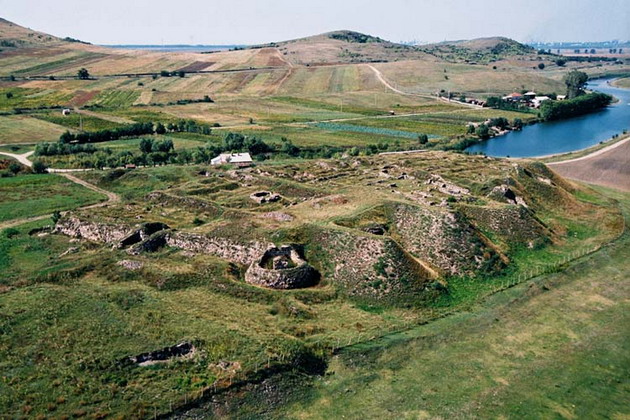
| Aerial view of the excavation area |
|---|
|
Link to the picture |
Numerous finds such as gold treasures, coins, jewelry, a bishop's cross , workshops, weapons, etc. confirm the economic activity of the local population. The archaeologists were able to differentiate between the early Roman and later and late Byzantine finds. There were also early Slavic legacies.
Inscriptions
Only a few inscriptions from the Roman period of the fort are known to date. A fragment of the inscription attests to a quaestor of the Lower Saxony municipality of Novidunum, who is no longer known by name.
Libra
The discovery of a scales officially checked in Constantinople , which was then sent to Dinogetia, became known nationwide. The Roman administration has intervened several times in history to ensure a forgery-proof weighing of goods. In 545, Emperor Justinian I (527-565) determined that in future it should be one of the tasks of the most important local church in every city to safely store the officially calibrated weights and measures. The scales found in Dinogetia were marked with the sign of the cross and named the Praefectus urbi Gerontius. It was the responsibility of these city prefects to take care of the scales and weights. In research it is assumed that the prefect mentioned in Dinogetia is identical to the one Flavius Gerontius, who held this office in Constantinople during the period from 559 to 561 AD.
Early Slavic finds
As evidence of early Slavic settlement, the fortress found various types of ceramics that were manufactured from the end of the 5th and 6th centuries. In addition, the semicircular head plate of an early Slavic bow brooch was found in association with these vessels. Early Slavic houses were excavated with the pottery inside the fortress. Their temporal horizon resulted from the catastrophic fire of the late 6th or early 7th century, which not only destroyed these houses, but the entire fortress.
Christian objects

Late Byzantine finds make up a large part of the remains in Dinogetia. This also includes Christian objects. Crosses with rounded corners are seen as typical products of the 11th and 12th centuries. Their production facilities were in the east of the empire. An important find was the Dinogetia double cross. Two relatively flat metal crosses, which can only be viewed from one side, were firmly joined together. The lower, larger one had circular bulges at its corners. The four ends of the cross widened outwards to the typical Byzantine shape. At the intersection of the two cross bars there was a relatively roughly designed bust of Jesus. Above this symbol of Christ stood a much smaller cross in Latin form, on which the full half-relief of the crucified one could be seen. Another relic was a small, 4.3 × 3 centimeter golden bronze cross from the 11th century in a mud hut that had been built in the area of the former fort baths. The importance of the find lies in its very rare shape. The arms look like a circular bundle of rods that thickens towards the ends and is held together in the middle. Half of a two-shell bronze mold was discovered at the main gate of the fortress. With the help of this tool, a simple small cross could be cast. Its shape is also hardly known from other medieval settlements in the region. Another 46 centimeter high Christian-Byzantine bronze cross was discovered in 1946. Of particular interest was the golden cross from the little church, which was built inside the fortification at an unknown time during the late 10th, 11th or 12th centuries. The symbol of Christ found there was created for a relic and was safely in the possession of a local bishop.
Musical instruments
During the excavations, two core slit flutes made of bone were discovered, which were made between the 10th and 12th centuries. One of these wind instruments was 11.5 centimeters long.
Jewelry, coin treasures
A gem from Dinogetia belongs to the very early Christian finds in Lower Moesia. It is seen as the property of a crypto-Christian soldier in the garrison, who in the 3rd century may have had a relationship with the Christian milieu of Syria or Egypt. This is what the found object suggests.
During the medieval settlement, some valuable pieces of gold were imported from Constantinople or imitated by local craftsmen in silver and bronze. So far, two medieval Byzantine coin treasures have been recovered, in 1939 and 1954. One of the hoards was buried in a ceramic pot in 1073/74.
Ceramics
Terra Sigillata was found in Dinogetia by various manufacturers. One delivered from the Central Gaulish pottery center Lezoux near Clermont-Ferrand . This type of pottery began there as early as the 1st century AD, and customers throughout the empire were supplied into the 3rd century. Another producer of sigillates from Dinogetia was already in Lower Moesia. It is possible that the goods came from the well-known pottery in Butowo, Bulgaria, which probably started production in the second half of the 2nd century and continued to produce at least into the 3rd century.
Monument protection
The entire archaeological site with all construction phases, the civil settlement and the necropolis are protected as historical monuments according to Act No. 422/2001 passed in 2001 and are in the national list of historical monuments with the LMI code TL-IsA-05795 ( Lista Monumentelor Istorice ). Responsible is the Ministry of Culture and National Heritage (Ministerul Culturii şi Patrimoniului Naţional), in particular the General Directorate for National Cultural Heritage, the Department of Fine Arts and the National Commission for Historical Monuments as well as other important institutions subordinate to the Ministry. Unauthorized excavations and the export of ancient objects are prohibited in Romania.
literature
- Ion Barnea: Dinogetia, ville byzantine du Bas-Danube. In: Byzantina 10, 1980, pp. 237-287.
- Alexandru Barnea: La forteresse de Dinogetia à la lumière des dernieres fouilles archéologiques. In: Studies on the military borders of Rome III. 13th International Limes Congress. Aalen 1983. Konrad Theiss Verlag, Stuttgart 1986, ISBN 3-8062-0776-3 , pp. 447-450.
- Norbert Angermann, Charlotte Bretscher-Gisiger (ed.): Lexicon of the Middle Ages. Volume 3. Artemis Verlag, Munich 1986, Sp. 1067.
- Gerda von Bülow: The Limes on the lower Danube from Diocletian to Heraklios. Lectures at the International Conference, Svištov, Bulgaria (September 1-5, 1998) . Nous, Sofia 1999, ISBN 954-90387-2-6 .
- Jan Burian: Dinogetia. In: The New Pauly (DNP). Volume 3, Metzler, Stuttgart 1997, ISBN 3-476-01473-8 , column 575 f.
Remarks
- ↑ Ptolemy 3, 8, 2; 10, 1 (polis).
- ↑ Ulrich Wanke: The Gotenkriege des Valens: Studies on topography and chronology in the lower Danube region from 366 to 378 AD. Verlag Peter Lang, 1990, ISBN 3-631-42396-9 , p. 88.
- ↑ Endre Tóth : The late Roman military architecture in Transdanubia . In: Archaeologiai Értesitő 134, Budapest 2009. p. 48.
- ↑ Endre Tóth: The late Roman military architecture in Transdanubia . In Archaeologiai Értesitő 134, Budapest 2009. p. 43.
- ↑ Sergey Torbatov: A Note on Dinogetia . In: Gerda von Bülow (ed.): The Limes on the lower Danube from Diocletian to Heraklios. Lectures at the International Conference, Svištov, Bulgaria (September 1-5, 1998) . Nous, Sofia 1999, ISBN 954-90387-2-6 . P. 272. Compare also: Burgus Leányfalu and Burgus Budakalász-Luppa csárda .
- ↑ Jan Kees Haalebos: Arae Flaviae IV. In: Bonner Jahrbücher 179, Cologne 1991. P. 828.
- ↑ Friedhelm Winkelmann, Wolfram Brandes (ed.): Sources on the history of early Byzantium (4th – 9th centuries). Inventory and problems. Akademie Verlag, Berlin 1990, ISBN 3-05-000566-1 , p. 113.
- ↑ Dimitŭr Simeonov Angelov: The Origin of the Bulgarian People. Akademie Verlag, Berlin 1980, p. 49.
- ↑ a b c Stefka Angelova, Rumjana Koleva: Archaeological evidence of early Slavic settlement. In: Post-Roman Towns, Trade and Settlement in Europe and Byzantium. Volume 2. Verlag Walter de Gruyter, Berlin, New York 2007, ISBN 978-3-11-018358-0 , p. 487.
- ↑ Christo Choliolcev, Renate Pillinger, Reinhardt Harreither (eds.): From Scythia to Dobrudža. 4th Bulgarian-Austrian Symposium in Dobric 1994. Bulgarian Research Institute in Austria. Vienna 1997, p. 44.
- ^ Ion Barnea: Roman-Byzantine basilicae discovered in Dobrogea between 1948-1958. In: Dacia NS 2, 1958, pp. 331-350; Barnea 1980, pp. 250-251; Christo Choliolcev, Renate Pillinger, Reinhardt Harreither (eds.): From Scythia to Dobrudža. 4th Bulgarian-Austrian Symposium in Dobric 1994. Bulgarian Research Institute in Austria. Vienna 1997, p. 44.
- ^ A b Academia Româna, Comisia de Istorie a Oraselor din România (ed.): Historia urbana. Volume 3. Editura Academiei Române, Bucharest 1995. p. 22. (in German).
- ^ Paul Stephenson: Byzantium's Balkan Frontier. A Political Study of the Northern Balkans, 900-1204. Cambridge University Press, Cambridge 2000, p. 84, table. ( (online; PDF, 2.2 MB) )
- ↑ a b Johannes Karayannopulos, Günter Weiß: Source studies on the history of Byzantium (324–1453) . Volume 1. Harrassowitz Verlag, Wiesbaden 1982, ISBN 3-447-02244-2 , p. 60.
- ↑ Lyudmila Dončeva-Petkova: To ethnicity of some necropolis of the 11th century in Bulgaria . In: Post-Roman Towns, Trade and Settlement in Europe and Byzantium. Volume 2. Verlag Walter de Gruyter, Berlin 2007, ISBN 978-3-11-018358-0 , p. 643. (in German).
- ^ Paul Stephenson: Byzantium's Balkan Frontier: A Political Study of the Northern Balkans, 900-1204. Cambridge University Press, Cambridge 2000, p. 83.
- ↑ Lyudmila Dončeva-Petkova: To ethnicity of some necropolis of the 11th century in Bulgaria . In: Post-Roman Towns, Trade and Settlement in Europe and Byzanticum. Volume 2. Verlag Walter de Gruyter, Berlin 2007, ISBN 978-3-11-018358-0 , pp. 643-644.
- ↑ IScM 5, 261a and 261b , 262 .
- ↑ Inscriptiones Scythiae Minoris Graecae et Latinae (IScM) 5, 264 .
- ^ A b Peter Weiß: New military diplomas. In: Journal of Papyrology and Epigraphy. No. 117, 1997, p. 253. (online; PDF, 5.3 MB) .
- ↑ a b CIL 16, 78 .
- ^ AE 1961, 128 .
- ↑ Alexandru Gh.Sonoc: Câteva considerații în legătură cu organizarea spectacolelor publice și percepția luptelor cu fiare și de gladiatori în Moesia Inferior, Regatul bosporan și în Dacia romană. In: Acta Terrae Septemcastrensis II. Editura Economică, Hermannstadt 2003, pp. 135–151.
- ↑ Liviu Petculescu: The Roman Army as a Factor of Romanisation in the North-Eastern part of Lower Moesia. In: Rome and the Black Sea Region: Domination, Romanization, Resistance. Black Sea Studies 5. Aarhus University Press, Copenhagen 2006, p. 32. (in English)
- ↑ ISCM 5, 260 .
- ↑ Peter Weiß: A diploma from Antoninus Pius for Moesia Inferior from Dec. 145 / Dec. 146. In: Journal of Papyrology and Epigraphy. No. 124, 1999, pp. 279-286. (online; PDF, 930 KB) .
- ↑ CIL 03, 14428
- ↑ Boris Gerov: The borders of the Roman province of Thrace to the foundation of the Aurelian Dacia. In: Rise and Fall of the Roman World . Volume II, 7, 1. Verlag Walter de Gruyter, Berlin 1979, ISBN 3-11-006875-3 , p. 221.
- ↑ IScM 5, 267 .
- ↑ AE 1980, 835 .
- ^ Peter Weiß: More diploma fragments from Moesia Inferior. In: Journal of Papyrology and Epigraphy. No. 124, Bonn 1999, pp. 287–288 (online; PDF; 692 KB) .
- ^ AE 1944, 068
- ^ AE 1950, 106
- ↑ AE 1976, 636a
- ↑ AE 1976, 636b
- ↑ ISCM 5, 262 .
- ^ AE 1990, 867
- ^ Syna Uenze, Karlheinz Dietz: The late antique fortifications of Sadovec (Bulgaria): Results of the German-Bulgarian-Austrian excavations, 1934-1937 . CH Beck publishing house. Munich 1992, ISBN 3-406-34568-9 , p. 387.
- ↑ Stefka Angelova, Rumjana Koleva: Archaeological evidence of early Slavic settlement. In: Post-Roman Towns, Trade and Settlement in Europe and Byzantium. Volume 2. Verlag Walter de Gruyter, Berlin / New York 2007, ISBN 978-3-11-021883-1 , p. 483.
- ↑ Evalds Mugurevics: The spread of Christianity in Latvia from the 11th century to the beginning of the 13th century . In Rome and Byzantium in the north . Volume II. Franz Steiner Verlag, Stuttgart 1998, p. 286 (illustration).
- ↑ Christo Choliolcev, Renate Pillinger, Reinhardt Harreither (eds.): From Scythia to Dobrudža. 4th Bulgarian-Austrian Symposium in Dobric 1994. Bulgarian Research Institute in Austria, Vienna 1997, p. 91.
- ^ Paul Stephenson: Byzantium's Balkan Frontier: A Political Study of the Northern Balkans, 900-1204. Cambridge University Press, Cambridge 2000, p. 86, table.
- ^ Karl Strobel (Ed.): Research on the Roman ceramic industry. Production, legal and distribution structures. Verlag Philipp von Zabern, Mainz 2000, ISBN 3-8053-2666-1 , p. 177.
- ↑ Octavian N. Bounegru: Comments on the Roman imports in Scythia Minor, 1. – 3. Century AD In: Munster contributions to ancient trading history Volume 7, 2. Scripta Mercaturae Verlag, St. Katharinen 1988, p. 77.
- ↑ Lista Monumentelor istorice. List of historical monuments on the website of the Ministry of Culture and National Heritage