Iparía district
| Iparía district | |
|---|---|
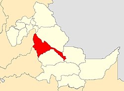
 Location of the district in the Ucayali region |
|
| Basic data | |
| Country | Peru |
| region | Ucayali |
| province | Coronel Portillo |
| Seat | Iparía |
| surface | 7364 km² |
| Residents | 10,328 (2017) |
| density | 1.4 inhabitants per km² |
| founding | July 2, 1943 |
| ISO 3166-2 | PE-UCA |
| politics | |
| Alcalde District | Fulgencio Tarazona Sánchez (2019-2022) |
| Political party | Ucayali Región con Futuro |
Coordinates: 9 ° 18 ′ S , 74 ° 26 ′ W
The Iparía district is located in the Coronel Portillo province in the Ucayali region in east-central Peru . The district was established on July 2, 1943. The district of Iparía has an area of 7364 km². The 2017 census counted 10,328 residents. In 1993 the population was 9278, in 2007 it was 10,774. The administrative seat of the district is the 169 m high village of Iparía with 1258 inhabitants (as of 2017). Iparía is located on the west bank of the Río Ucayali , 103 km south of the provincial and regional capital Pucallpa . The area is inhabited by the indigenous people of the Shipibo-Conibo , whose language belongs to the language family of the Pano languages .
Geographical location
The district of Iparía is located on the western edge of the Amazon basin in the extreme south of the province of Coronel Portillo. It has a maximum length in NW-SE direction of 210 km. The Río Ucayali crosses the district in a northerly direction. The Sira Mountains run along the western district boundary. In the north, the district extends to the confluence of the Río Pachitea in the Río Ucayali. In the southeast, the district includes the catchment area of the Río Sheshea , a right tributary of the Río Ucayali.
The district of Iparía borders in the southwest with the district Constitución ( province Oxapampa ), in the west with the districts Yuyapichis , Puerto Inca , Tournavista and Honoria (all in the province Puerto Inca ), in the northeast with the district Masisea , in the extreme southeast with the district Yurúa ( Atalaya Province ) and in the south to the Tahuanía District (also in Atalaya Province).
Individual evidence
- ↑ a b PERU: Ucayali region - provinces and districts . www.citypopulation.de. Retrieved April 18, 2020.