
Dumlupinar
| Dumlupinar | ||||
|
||||
| Basic data | ||||
|---|---|---|---|---|
| Province (il) : | Kutahya | |||
| Coordinates : | 38 ° 51 ' N , 29 ° 59' E | |||
| Height : | 1231 m | |||
| Residents : | 1,310 (2018) | |||
| Telephone code : | (+90) 274 | |||
| Postal code : | 43820 | |||
| License plate : | 43 | |||
| Structure and administration (as of 2019) | ||||
| Structure : | 4 malls | |||
| Mayor : | Şemsettin Akağaç ( AKP ) | |||
| Website: | ||||
| Dumlupınar County | ||||
| Residents : | 2,999 (2018) | |||
| Surface: | 250 km² | |||
| Population density : | 12 inhabitants per km² | |||
| Kaymakam : | Abdulkerem Abbasoğlu | |||
| Website (Kaymakam): | ||||


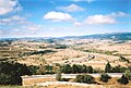
Dumlupınar is a city and capital of the district of the same name in the Turkish province of Kütahya . The city is located about 65 kilometers south of the provincial capital Kütahya . According to the city seal, the place received the status of a municipality ( Belediye ) in 1956 .
The district is located in the south of the province. It borders on Altıntaş County in the north , Sinanpaşa County ( Afyonkarahisar Province ) in the south-east, and Banaz County ( Uşak Province ) in the south-west . The city is on the D615 road, a cross connection from the D650 to the E 90 which runs south . In the west of the district there are foothills of the Murat Dağı Mountains . The district includes part of the historical national park Başkomutan Tarihi Milli Parkı , which marks the site of the Battle of Dumlupınar , where the Turkish army won a victory against the Greeks in the Turkish Liberation War in 1922.
The district was established in 1987 when Bucak Dumlupınar was spun off from Altıntaş district. At the last census before the change of area (1985) the Bucak counted 6,789 inhabitants, of which 3,252 were in the Bucak capital ( Bucak Merkezi ), the Belediye Dumlupınar. At the end of 2019, the district consisted of the district town and ten villages with an average of 169 residents. The population ranged from 335 ( Büyükaslıhanlar ) to 68 ( Arpalı ). Six villages had more than 169 inhabitants. The district had the lowest population density (12.0 inh. Per km²)
Web links
- Battle of Dumlupinar

1
2

3

4th

.jpg)
.jpg)
.jpg)
Individual evidence
- ↑ a b Türkiye Nüfusu İl ilçe Mahalle Köy Nüfusları , accessed on July 7, 2019
- ↑ Başkomutan Tarihi Milli Parkı ( Memento from August 8, 2013 in the Internet Archive )
